Olean, Indiana facts for kids
Quick facts for kids
Olean, Indiana
|
|
|---|---|
| Country | United States |
| State | Indiana |
| County | Ripley |
| Township | Brown |
| Elevation | 955 ft (291 m) |
| Time zone | UTC-5 (Eastern (EST)) |
| • Summer (DST) | UTC-4 (EDT) |
| ZIP code |
47882
|
| Area code(s) | 812, 930 |
| GNIS feature ID | 440628 |
Olean is a small, quiet place in Ripley County, Indiana. It is known as an unincorporated community, which means it doesn't have its own local government like a city or town. Olean is located within Brown Township.
A Look Back: Olean's History
Olean was first planned out in the year 1858. The people who settled here named it after a place called Olean, New York.
A post office opened in Olean way back in 1844. It helped people send and receive mail for many years. However, the post office eventually closed down in 1905.
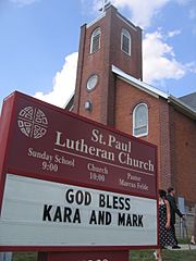
A special event happened in 2007. The Indiana Senate honored St. Paul Lutheran Church in Olean. This was to celebrate the church's 150th birthday!
Where is Olean?
Olean is located along Indiana State Road 129. If you travel about 6 miles (9.7 km) north, you'll reach Versailles. You can also find Versailles State Park nearby.
Other small communities are close to Olean too. Cross Plains is about 3.3 miles (5.3 km) south. Friendship is a bit further, about 6.5 miles (10.5 km) to the southeast.
 | William L. Dawson |
 | W. E. B. Du Bois |
 | Harry Belafonte |


