
Oneonta Gorge facts for kids
Quick facts for kids Lower Oneonta Falls |
|
|---|---|
| Oneonta Gorge Falls | |
 |
|
| Lua error in Module:Infobox_mapframe at line 185: attempt to index field 'wikibase' (a nil value). | |
| Location | 45°35′08″N 122°04′22″W / 45.58556°N 122.07278°W Multnomah County, Oregon, United States |
| Type | Plunge |
| Total height | 100 feet (30 m) |
| Number of drops | 1 |
| Middle Oneonta Falls | |
|---|---|
| Oneonta Falls | |
| Lua error in Module:Infobox_mapframe at line 185: attempt to index field 'wikibase' (a nil value). | |
| Location | 45°35′07″N 122°04′22″W / 45.58515°N 122.07279°W Multnomah County, Oregon, United States |
| Type | Horsetail |
| Total height | 24 feet (7.3 m) |
| Number of drops | 1 |
| Average flow rate |
150.0 cfs |
| Upper Oneonta Falls | |
|---|---|
| Oneonta Falls | |
| Lua error in Module:Infobox_mapframe at line 185: attempt to index field 'wikibase' (a nil value). | |
| Location | 45°34′56″N 122°04′22″W / 45.58235°N 122.07278°W Multnomah County, Oregon (no trail access) |
| Type | Plunge |
| Total height | 65 feet (20 m) |
| Number of drops | 1 |
| Average flow rate |
100.0 cfs |
| Triple Falls | |
|---|---|
| Lower Oneonta Falls, Oneonta Gorge Falls | |
| Lua error in Module:Infobox_mapframe at line 185: attempt to index field 'wikibase' (a nil value). | |
| Location | 45°34′43″N 122°04′20″W / 45.57861°N 122.07222°W Multnomah County, Oregon, United States |
| Type | Segmented |
| Total height | 64 feet (20 m) |
| Number of drops | 1 |
| Average flow rate |
200 cfs |
The Oneonta Gorge is a beautiful and unique canyon located in the Columbia River Gorge area of Oregon. It's a special place known for its amazing natural features. The United States Forest Service has even called it a "botanical area." This means it's important for its plant life.
The gorge has walls made of 25-million-year-old basalt rock. These ancient rocks are home to many different kinds of plants. You can find ferns, mosses, and lichens growing here. Many of these plants are rare and only grow in the Columbia River Gorge. Oneonta Gorge is also famous for its 50 types of wildflowers, shrubs, and trees. It truly is one of the most dramatic canyons in Oregon.
Contents
Exploring Oneonta's Waterfalls
Oneonta Creek flows through the gorge, creating four main waterfalls. Each waterfall offers a different experience for visitors.
Discovering Lower Oneonta Falls
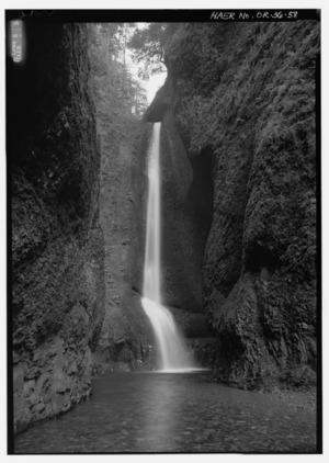
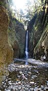
Lower Oneonta Falls is a stunning waterfall hidden deep inside a narrow part of the canyon called a slot canyon. There isn't a regular path or boardwalk to reach it. To see this waterfall, you need to walk upstream from where the creek meets the Historic Columbia River Highway.
Getting a full view of the falls can be an adventure. You might need to wade through water that can be very deep. The water level changes depending on the season and how much snow has melted. It's a true wilderness experience!
Middle and Upper Oneonta Falls
Middle Oneonta Falls is easy to spot from a footpath. Many people often mistake it for one of the other falls. It's a lovely sight for hikers.
Upper Oneonta Falls is about a mile upstream from the middle falls. Reaching it is much harder. You might need to climb along the creek or carefully go down a canyon wall to see it. This makes it a more challenging adventure for experienced explorers.
Viewing Triple Falls
The fourth major waterfall is called Triple Falls. You can see this waterfall from several different spots. These viewing points are located on the higher trails within the canyon. It offers a great reward for those who hike the upper paths.
Unique Plants and Ancient Rocks
Oneonta Gorge is a special place for nature lovers. The United States Forest Service has named it a botanical area. This means it's protected because of its unique plants.
The gorge walls are made of very old basalt rock, about 25 million years old. These rocks provide a perfect home for many types of plants. You can see various ferns, mosses, and lichens. Some of these plants are found only in the Columbia River Gorge. The gorge is also home to about 50 different kinds of wildflowers, flowering shrubs, and trees. This makes it a truly rich and diverse natural area.
History of the Gorge
The Oneonta Gorge was first photographed by a man named Carleton Watkins. He was from a town called Oneonta, New York. Carleton traveled west in 1851 during the time of the California Gold Rush.
When he saw the beautiful falls, he decided to name them after his hometown. This is how Oneonta Falls got its name, connecting this Oregon wonder to a town far away in New York.
Trail Challenges and Closures
The trails in Oneonta Gorge have faced some difficulties over the years. These issues are caused by both nature and human activity. In the late 1990s, large boulders, as big as pickup trucks, fell into the stream. This partly blocked the water flow.
Later, a large log jam formed in the narrow slot canyon. This created a dangerous situation for hikers trying to pass through. Because of these dangers, trails providing access to the waterfalls have been closed. As of November 2020, these trails remain closed. This is due to damage from the 2017 Eagle Creek Fire, which affected much of the area.
Gallery
-
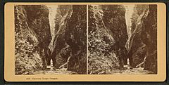
Oneonta Gorge, Oregon, from Robert N. Dennis collection of stereoscopic views
-
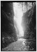
Oneonta Gorge
-
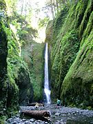
Oneonta Gorge falls
-
Lower Oneonta Gorge falls
-
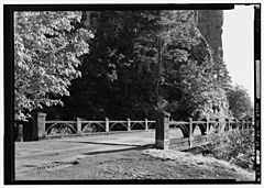
Oneonta Gorge Creek Bridge on the Historic Columbia River Highway
-
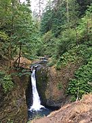
Middle Oneonta Falls


