Orography facts for kids

Orography is the study of how mountains, hills, and other high places on Earth are shaped. It looks at the height and features of these elevated areas. Orography is part of a bigger science called geomorphology, which studies how Earth's landforms are made. The word 'orography' comes from ancient Greek words meaning 'hill' and 'to write'.
How Orography is Used
Mountains and high lands really affect the world's weather and climate. For example, the high areas in East Africa help decide how strong the Indian monsoon will be. In science, when experts use computer models to predict weather, orography helps them map out the land.
Orography is also used when listing a river's tributaries (smaller rivers that flow into it) or towns along its banks. When these are listed in 'orographic sequence', it means they are ordered from the highest point (closest to where the river starts) down to the lowest point (closest to where the river ends). This is similar to how river branches are ordered in the Strahler Stream Order system.
Orographic Precipitation
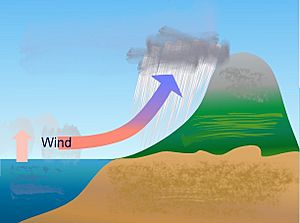
Orographic precipitation is rain, snow, or other forms of precipitation that happens when moist air is forced to rise over mountains or high land. This lifting of air can happen in two main ways:
- When large amounts of air are pushed upwards by the shape of the land.
- When warm, moist air moves up a mountain slope, often because the mountain surface gets heated by the sun during the day.
As the air rises, it expands and cools down. This cooling can make the air temperature drop to its dew point. When this happens, the water vapor in the air turns into tiny water droplets, forming a cloud. If enough water vapor condenses, these droplets can grow big enough to fall to the ground as precipitation.
Weather forecasters pay close attention to terrain-induced precipitation. Orography plays a big role in deciding what kind of precipitation will fall, how much there will be, how strong it will be, and how long it will last. Scientists have found that the width of a mountain barrier, how steep its slopes are, and how fast the air moves upwards are key factors for getting the most orographic precipitation. Computer models show that narrow barriers and steeper slopes create stronger upward air movements, which then increase the amount of rain or snow.
Orographic precipitation is common on oceanic islands, like the Hawaiian Islands and New Zealand. Most of the rainfall on these islands happens on the side facing the wind. The other side, called the leeward side, tends to be very dry, sometimes almost like a desert. This means there can be huge differences in rainfall amounts over short distances. Coastal areas might get about 20 to 30 inches (500 to 760 mm) of rain per year, while inland uplands might get over 100 inches (2,540 mm) per year. Leeward coastal areas are especially dry, like Waikiki with less than 20 inches (500 mm) per year. Meanwhile, the tops of moderately high uplands can be very wet, such as Wai'ale'ale on Kaua'i, which gets about 475 inches (12,000 mm) per year.
Another place where orographic precipitation happens is the Pennines in the north of England. The west side of the Pennines gets more rain than the east. This is because clouds, usually coming from the west, are forced up and over the hills. This causes most of the rain to fall on the western slopes. You can see this clearly between Manchester (to the west) and Leeds (to the east). Leeds gets less rain because it's in a rain shadow about 12 miles (19 km) from the Pennines.
See also
 In Spanish: Orografía para niños
- Coverage (telecommunication)
- Orographic lift
 | Mary Eliza Mahoney |
 | Susie King Taylor |
 | Ida Gray |
 | Eliza Ann Grier |


