Oronogo, Missouri facts for kids
Quick facts for kids
Oronogo, Missouri
|
|
|---|---|

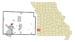
Location of Oronogo, Missouri
|
|
| Country | United States |
| State | Missouri |
| County | Jasper |
| Area | |
| • Total | 2.51 sq mi (6.51 km2) |
| • Land | 2.49 sq mi (6.44 km2) |
| • Water | 0.03 sq mi (0.07 km2) |
| Elevation | 955 ft (291 m) |
| Population
(2020)
|
|
| • Total | 2,558 |
| • Density | 1,028.96/sq mi (397.32/km2) |
| Time zone | UTC-6 (Central (CST)) |
| • Summer (DST) | UTC-5 (CDT) |
| ZIP code |
64855
|
| Area code(s) | 417 |
| FIPS code | 29-54920 |
| GNIS feature ID | 2396083 |
Oronogo is a city located in Jasper County, Missouri, in the United States. In 2020, about 2,558 people lived there. It is part of the larger Joplin Metropolitan Area. This means it's connected to the city of Joplin and the surrounding communities.
Contents
History of Oronogo
Oronogo was officially planned and laid out in 1856. The city's unique name has an interesting story.
How Oronogo Got Its Name
Originally, the area was called "Minersville." However, people discovered that another town already had that name. So, the community held a meeting to choose a new name.
Many ideas were suggested, but none seemed quite right. Then, a man in the back of the room shouted, "It's Ore or no go!" He was talking about the mining operations that were very important to the town.
A local leader, Colonel J. M. Young, liked the idea. He suggested using the Spanish word "Oro," which means "gold," instead of "ore." He also changed the ending to make the name sound better. He pronounced it "Oronogo," and everyone at the meeting agreed it was a perfect fit.
Geography of Oronogo
Oronogo is a small city in terms of its size. According to the United States Census Bureau, the city covers a total area of about 2.52 square miles (6.52 square kilometers).
Most of this area, about 2.49 square miles (6.45 square kilometers), is land. A very small part, about 0.03 square miles (0.08 square kilometers), is water.
Population and People
The number of people living in Oronogo has changed a lot over the years. Here's a quick look at how the population has grown and shrunk:
| Historical population | |||
|---|---|---|---|
| Census | Pop. | %± | |
| 1880 | 700 | — | |
| 1900 | 2,073 | — | |
| 1910 | 1,912 | −7.8% | |
| 1920 | 981 | −48.7% | |
| 1930 | 551 | −43.8% | |
| 1940 | 593 | 7.6% | |
| 1950 | 519 | −12.5% | |
| 1960 | 513 | −1.2% | |
| 1970 | 492 | −4.1% | |
| 1980 | 525 | 6.7% | |
| 1990 | 595 | 13.3% | |
| 2000 | 976 | 64.0% | |
| 2010 | 2,381 | 144.0% | |
| 2020 | 2,558 | 7.4% | |
| U.S. Decennial Census | |||
Oronogo's Population in 2010
In 2010, there were 2,381 people living in Oronogo. These people made up 772 households, with 646 of them being families.
- Most people (about 91.9%) were White.
- A small number were Native American (2.0%) or Asian (0.6%).
- Some people were from other races (1.4%) or a mix of two or more races (3.8%).
- About 4.0% of the population identified as Hispanic or Latino.
The average age of people in Oronogo in 2010 was 29 years old. Many young people lived there, with about 35.5% of residents being under 18 years old.
Education in Oronogo
Students in Oronogo attend schools that are part of the Webb City R-VII School District. The main high school for the district is Webb City High School.
See also
 In Spanish: Oronogo (Misuri) para niños

