Orpierre facts for kids
Quick facts for kids
Orpierre
|
||
|---|---|---|

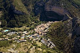
An aerial view of the village in Orpierre. The RN75 road leads in from the left, from Eyguians.
|
||
|
||
| Country | France | |
| Region | Provence-Alpes-Côte d'Azur | |
| Department | Hautes-Alpes | |
| Arrondissement | Gap | |
| Canton | Serres | |
| Intercommunality | Baronnies | |
| Area
1
|
27.57 km2 (10.64 sq mi) | |
| Population
(Jan. 2021)
|
Lua error in Module:Wd at line 1,575: attempt to index field 'wikibase' (a nil value). | |
| Time zone | UTC+01:00 (CET) | |
| • Summer (DST) | UTC+02:00 (CEST) | |
| INSEE/Postal code |
05097 /05700
|
|
| Elevation | 619–1,323 m (2,031–4,341 ft) (avg. 698 m or 2,290 ft) |
|
| 1 French Land Register data, which excludes lakes, ponds, glaciers > 1 km2 (0.386 sq mi or 247 acres) and river estuaries. | ||
Orpierre is a charming commune (which is like a small town or village) located in the Hautes-Alpes department in southeastern France. It's known for its beautiful natural surroundings and is a popular spot for outdoor activities.
Contents
Orpierre: A French Village
Orpierre is nestled in the Hautes-Alpes department. This area is famous for its stunning mountains and clear skies. A "commune" is the smallest administrative area in France. It can be a town, a village, or even just a small group of houses.
How Many People Live in Orpierre?
The number of people living in Orpierre has changed over the years. In 1962, there were 231 residents. By 1990, the population grew to 335 people. In 2008, about 324 people called Orpierre home.
Getting Around Orpierre
Several roads help people travel to and from Orpierre. The main roads that pass through the commune are the D30, D130, and D230. These roads connect Orpierre to other nearby towns and villages.
See also
 In Spanish: Orpierre para niños
 | Charles R. Drew |
 | Benjamin Banneker |
 | Jane C. Wright |
 | Roger Arliner Young |


