Osgood, Missouri facts for kids
Quick facts for kids
Osgood, Missouri
|
|
|---|---|
|
Village
|
|

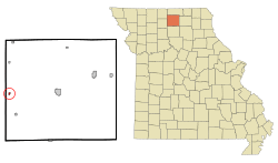
Location of Osgood, Missouri
|
|
| Country | United States |
| State | Missouri |
| County | Sullivan |
| Area | |
| • Total | 0.18 sq mi (0.47 km2) |
| • Land | 0.18 sq mi (0.47 km2) |
| • Water | 0.00 sq mi (0.00 km2) |
| Elevation | 817 ft (249 m) |
| Population
(2020)
|
|
| • Total | 24 |
| • Density | 131.87/sq mi (50.93/km2) |
| Time zone | UTC-6 (Central (CST)) |
| • Summer (DST) | UTC-5 (CDT) |
| FIPS code | 29-55424 |
| GNIS feature ID | 2399591 |
Osgood is a small village located in the western part of Sullivan County, Missouri, in the United States. In 2020, the village had a population of 24 people. It's a quiet place with a rich history.
Contents
History of Osgood
Osgood was officially planned and laid out in 1886. It was probably named after someone who worked for the railroad. A post office opened in Osgood in 1888, helping people send and receive mail. This post office served the community for many years until it closed in 1965.
Geography and Location
Osgood is found in western Sullivan County. It is located right next to Missouri Route 139, just west of Medicine Creek. The town of Milan is about 13 miles to the east. Other nearby towns include Harris to the north and Humphreys to the south, both along Route 139. A railroad line, the Chicago, Milwaukee, St. Paul and Pacific Railroad, runs along the east side of the village.
According to the United States Census Bureau, Osgood covers a total area of about 0.18 square miles (0.47 square kilometers). All of this area is land.
Population Information
The number of people living in Osgood has changed over the years. Here is a look at the population from 1910 to 2020:
| Historical population | |||
|---|---|---|---|
| Census | Pop. | %± | |
| 1910 | 204 | — | |
| 1920 | 272 | 33.3% | |
| 1930 | 206 | −24.3% | |
| 1940 | 183 | −11.2% | |
| 1950 | 173 | −5.5% | |
| 1960 | 135 | −22.0% | |
| 1970 | 108 | −20.0% | |
| 1980 | 93 | −13.9% | |
| 1990 | 53 | −43.0% | |
| 2000 | 51 | −3.8% | |
| 2010 | 48 | −5.9% | |
| 2020 | 24 | −50.0% | |
| U.S. Decennial Census | |||
What the 2010 Census Showed
In 2010, a total of 48 people lived in Osgood. These people lived in 19 different homes, and 11 of these were families. The village had about 267 people per square mile. There were 31 housing units, which are places where people can live.
Most of the people in Osgood were White (64.6%). Some were Native American (14.6%), and others were from different backgrounds (18.8%). About 20.8% of the population identified as Hispanic or Latino.
Out of the 19 homes, about 21% had children under 18 living there. About 26% were homes with married couples. Some homes had a female head of household without a husband (15.8%), and some had a male head of household without a wife (15.8%). About 42% of the homes were not families. On average, there were about 2.5 people in each home.
The average age of people in the village was 37 years old. About 23% of residents were under 18. About 8% were between 18 and 24. The largest group, about 33%, was between 25 and 44 years old. About 23% were between 45 and 64, and 12.5% were 65 or older. Slightly more than half of the population (52.1%) was male, and 47.9% was female.
See also
 In Spanish: Osgood (Misuri) para niños
 | James B. Knighten |
 | Azellia White |
 | Willa Brown |

