
Osney Lock facts for kids

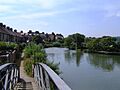
Osney Lock, looking upstream from the north
|
|
| Waterway | River Thames |
|---|---|
| County | Oxfordshire |
| Maintained by | Environment Agency |
| Operation | Hydraulic |
| First built | 1790 |
| Latest built | 1905 |
| Length | 34.64 m (113 ft 8 in) |
| Width | 5.25 m (17 ft 3 in) |
| Fall | 1.89 m (6 ft 2 in) |
| Above sea level | 185' |
| Distance to Teddington Lock |
93 miles |
Osney Lock is a special kind of gate on the River Thames in Oxford, England. It helps boats move up and down the river where the water level changes. This lock is right next to a small area called Osney, which is almost like an island.
The very first lock here was built in 1790. It was made of stone by a person named Daniel Harris. He built it for the group that managed the Thames River at the time.
Near the lock, there's a big building complex. It belongs to the Environment Agency, which looks after the River Thames. They have a small office building right in front of the lock house. The weir, which controls the water flow, is just upstream from the lock. It has two parts and helps fill the Osney pool.
South of the lock, you'll find the Osney Mill Marina where boats are kept. There's also Osney Cemetery nearby. The Oxford railway station is close by to the northwest, on Botley Road.
Contents
Osney Lock: A Gateway on the Thames

Osney Lock is an important part of the River Thames. It allows boats to travel safely past changes in water height. Think of it like a water elevator for boats! It connects different parts of the river.
A Look Back: History of the Lock
Long ago, the main river path was a different branch called Bulstake Stream. The current river path was made a long time ago by monks from Osney Abbey. This was a monastery on the west side of the Osney island. They built it to power a mill, just like at Abingdon.
There was an old weir (a small dam) owned by the Abbey in this spot. People started thinking about building a lock here in 1787. The river path became the main route for boats when the lock was built in 1790. Daniel Harris, who built it, used prisoners from Oxford jail. This helped him offer the cheapest price for the work. The lock was last rebuilt in 1905 to make it better and stronger.
Finding Your Way to Osney Lock
You can easily reach Osney Lock by walking along the towpath. The towpath is a path next to the river. You can find it a short distance from Osney Bridge. This bridge is on the A420 Botley Road, which is west of Oxford city centre.
Exploring the River Above the Lock
As you go upstream from the lock, the river passes an old electricity station. Osney Bridge crosses the river near Oxford railway station. On the east side of the river, you'll see parts of Oxford city.
After some garden plots on the west bank and houses on the east, you'll find a cool spot. It's like a water crossroads called "Four Rivers." From here, you can connect to the Oxford Canal through the Sheepwash Channel. In another direction, you'll find Bulstake Stream.
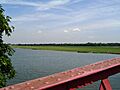
The river then flows through areas with willow trees. It continues until it reaches Fiddler's Island. There used to be an old weir and a special type of lock here. Now, a rainbow-shaped bridge called Medley Footbridge crosses the main river channel. On the other side of the island is Castle Mill Stream. This is an old river path that goes east, closer to Oxford's centre. It joins the Thames again below Osney Lock. On the eastern bank, you'll see the wide-open space of Port Meadow. This meadow stretches all the way to Wolvercote.
Checking Your Speed on the River
Near Port Meadow, upstream from Medley Boat station, there are special markers. These are called navigation transit markers. They help boat users check their speed. If you are in a powered boat, you should not pass between these markers in less than one minute. This helps keep everyone safe on the water.
Walking the Thames Path
The Thames Path is a long walking trail. It crosses to the Oxford side of the river at Osney Bridge. Then, it goes across Fiddler's Island and over Medley Footbridge. After that, it returns to the western bank. The path continues from there all the way to Godstow Lock.
Images for kids
-
Oxford shows its back to the river below Four Rivers
-
Port Meadow looking upstream from Medley Footbridge


