Ouargla Province facts for kids
Quick facts for kids
Ouargla Province
ولاية ورقلة
|
|
|---|---|

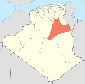
Map of Algeria highlighting Ouargla
|
|
| Country | |
| Capital | Ouargla |
| Area | |
| • Total | 211,980 km2 (81,850 sq mi) |
| Population
(2008)
|
|
| • Total | 552,539 |
| • Density | 2.60656/km2 (6.75096/sq mi) |
| Time zone | UTC+01 (CET) |
| Area Code | +213 (0) 32 |
| ISO 3166 code | DZ-30 |
| Districts | 10 |
| Municipalities | 21 |
Ouargla (also called Warqla) is a large area in eastern Algeria. It is like a state or region within the country. The main city and capital of this province is also called Ouargla.
Other important towns in Ouargla Province include Temacine, Touggourt, and Hassi Messaoud. A big part of this province is covered by the Issaouane Erg desert, which is a huge area of sand dunes.
How Ouargla Province is Organized
Ouargla Province is divided into smaller parts to help manage it. It has 10 main areas called districts. Within these districts, there are 21 even smaller areas known as communes or municipalities. These are like local towns or villages.
Districts of Ouargla Province
Here are the 10 districts that make up Ouargla Province:
- El Borma
- El Hadjira
- Hassi Messaoud
- Mégarine
- N'Goussa
- Ouargla (This is where the capital city is located!)
- Sidi Khouiled
- Taïbet
- Témacine
- Touggourt
See also
 In Spanish: Provincia de Uargla para niños
Black History Month on Kiddle
Famous African-American Activists:
 | Aurelia Browder |
 | Nannie Helen Burroughs |
 | Michelle Alexander |

All content from Kiddle encyclopedia articles (including the article images and facts) can be freely used under Attribution-ShareAlike license, unless stated otherwise. Cite this article:
Ouargla Province Facts for Kids. Kiddle Encyclopedia.
