
Outflow (meteorology) facts for kids

Outflow is the air that spreads out from a thunderstorm. Think of it like a big puff of wind pushing away from the storm. When a storm has a lot of outflow, it usually means it's a strong and "healthy" storm. This air can travel far from the main storm.
How We See Outflow
The edge of this spreading air, called the outflow boundary, can often be seen on weather radar. This is because the cold air from the storm's downdraft (air sinking from the storm) pushes into the warmer air around it. This meeting of different air temperatures creates a clear line.
What Radar Detects
When the cold outflow air meets the warm air, it causes things like dust, tiny particles (aerosols), and even insects to gather. This gathering makes a stronger signal on the radar. This is how meteorologists can spot the outflow boundary, even before the main storm arrives.
New Clouds and Storms
Sometimes, new clouds can form along the leading edge of the outflow. Even new thunderstorms can start to grow there. This is because the rising warm air is pushed up by the colder outflow air. This makes it easier to find the outflow boundary when radar is set to "precipitation mode." The picture on the right shows a very strong outflow boundary moving ahead of a group of storms. Often, the outflow boundary will curve or "bow" in the direction it is moving fastest. This bowing shape can be a sign of very strong winds.
Images for kids
-
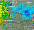
Radar image animation of an outflow boundary of a storm approaching Tulsa, Oklahoma. The outflow boundary's weak echo moves left-to-right and passes overhead of the Doppler radar station. The outflow produces a gust front that moves ahead of the main thunderstorm.
-
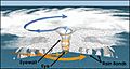
Structure of a tropical cyclone. The upper level outflow is depicted by cirrus clouds in the upper part of the schematic


