
Packwaukee (CDP), Wisconsin facts for kids
Quick facts for kids
Packwaukee, Wisconsin
|
|
|---|---|
|
Census-designated place
|
|

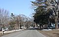
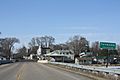
Looking north in downtown Packwaukee
|
|

Packwaukee (CDP), Wisconsin
Location in Wisconsin
|
|
| Country | United States |
| State | Wisconsin |
| County | Marquette |
| Area | |
| • Total | 0.480 sq mi (1.24 km2) |
| • Land | 0.480 sq mi (1.24 km2) |
| • Water | 0 sq mi (0 km2) |
| Elevation | 781 ft (238 m) |
| Population
(2010)
|
|
| • Total | 262 |
| • Density | 545.8/sq mi (210.7/km2) |
| Time zone | UTC-6 (Central (CST)) |
| • Summer (DST) | UTC-5 (CDT) |
| ZIP code |
53953
|
| Area code(s) | 608 |
| GNIS feature ID | 1570986 |
Packwaukee is a small community in Marquette County, Wisconsin, in the United States. It is known as a census-designated place, which means it's a special area that the government counts for population surveys.
Packwaukee is located right on the north side of Buffalo Lake. This lake is part of the Fox River, which is an important waterway in Wisconsin. The community is about 7 miles (11 km) west-southwest of a town called Montello.
In 2010, about 262 people lived in Packwaukee. It has its own post office with the ZIP code 53953.
Images for kids
-
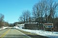
Sign
-
Looking east
-
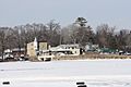
Panorama across Buffalo Lake on the Fox River
-
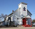
Presbyterian church
-
Sign on County D


See also
 In Spanish: Packwaukee (condado de Marquette) para niños

All content from Kiddle encyclopedia articles (including the article images and facts) can be freely used under Attribution-ShareAlike license, unless stated otherwise. Cite this article:
Packwaukee (CDP), Wisconsin Facts for Kids. Kiddle Encyclopedia.