Palak facts for kids
Quick facts for kids
Palak
|
|
|---|---|

Palak is in Abbottabad District
|
|
| Country | |
| Province | Khyber Pakhtunkhwa |
| District | Abbottabad |
| Tehsil | Abbottabad |
| Population | |
| • Total | 18,997 |
Palak is a special area in Pakistan, like a small local government district. It's one of 51 such areas, called Union Councils, found in the Abbottabad District. This district is part of the Khyber Pakhtunkhwa province in Pakistan.
Where is Palak Located?
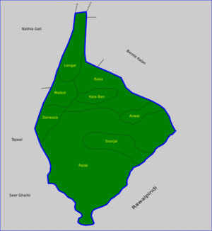
Palak is located on the southeastern edge of the Abbottabad District. It shares borders with the Punjab province and also with Kashmir. Palak is also close to other Union Councils within the Abbottabad District. These include Seer Gharbi to its west, Nathiagali to the north, and Malkot to the northwest. Many people see Palak as an important entry point to the Abbottabad District.
Understanding Palak's Subdivisions
Palak is the largest Union Council in an area known as Circle Bakote. In the year 2000, Malkot, which used to be its own Union Council, became part of Palak.
The Palak Union Council is divided into several smaller areas. These areas include:
- Arwar
- Darwaza
- Kala Bon
- Longal
- Malkot
- Palak
- Riala (also known as Riyala)
- Soorjal (also known as Surajaal)
Who Lives in Palak?
The total population of Palak is about 18,997 people. The main groups of people, or tribes, living in Palak are the Dhund Abbasi, the Gujars, and the Sattis.
 | Janet Taylor Pickett |
 | Synthia Saint James |
 | Howardena Pindell |
 | Faith Ringgold |


