Palmer (CDP), Massachusetts facts for kids
Quick facts for kids
Palmer, Massachusetts
|
|
|---|---|
|
Former CDP
|
|

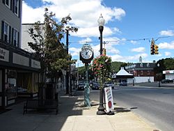
Main Street
|
|
| Country | United States |
| State | Massachusetts |
| County | Hampden |
| City | Palmer |
| Area | |
| • Total | 4.1 sq mi (10.7 km2) |
| • Land | 4.1 sq mi (10.6 km2) |
| • Water | 0.0 sq mi (0.1 km2) |
| Elevation | 344 ft (105 m) |
| Population
(2000)
|
|
| • Total | 3,900 |
| • Density | 954.2/sq mi (368.4/km2) |
| Time zone | UTC-5 (Eastern (EST)) |
| • Summer (DST) | UTC-4 (EDT) |
| ZIP code |
01069
|
| Area code(s) | 413 |
| FIPS code | 25-52070 |
| GNIS feature ID | 0609578 |
Palmer is a community in Hampden County, Massachusetts, United States. It used to be called a census-designated place (CDP), which is a special area defined by the government for counting people.
In 2000, about 3,900 people lived in Palmer. It is part of the larger Springfield area. Many people know this part of Palmer as Depot Village. This name comes from a beautiful old train station built by a famous architect named H.H. Richardson.
Contents
Where is Palmer?
Palmer is located in the state of Massachusetts. It sits at specific geographic coordinates: 42.157157 degrees North and -72.326855 degrees West.
How Big is Palmer?
According to the United States Census Bureau, Palmer covers a total area of about 10.6 square kilometers (or 4.1 square miles). Almost all of this area is land. Only a very small part, about 0.1 square kilometers (0.04 square miles), is water.
Who Lives in Palmer?
In 2000, there were 3,900 people living in Palmer. These people lived in 1,778 homes, and 970 of these were families.
Population Details
Palmer had about 368 people living in each square kilometer (or 954 people per square mile). There were also 1,874 housing units, with about 177 units per square kilometer (or 458 units per square mile).
Most of the people in Palmer were White (95.33%). There were also smaller groups of Black or African American (1.44%), Native American (0.28%), and Asian (1.03%) residents. About 1.41% of people were from two or more races. Around 1.51% of the population identified as Hispanic or Latino.
Homes and Families
Out of all the homes in Palmer, about 25.9% had children under 18 living there. About 37.1% of homes were married couples living together. Around 12.7% of homes had a female head of household with no husband present.
Many homes (45.4%) were not families. About 39.3% of all homes were single individuals. Also, 16.7% of homes had someone living alone who was 65 years old or older. On average, there were 2.16 people in each home and 2.89 people in each family.
Age and Income
The people in Palmer had different ages:
- 22.4% were under 18 years old.
- 6.6% were between 18 and 24 years old.
- 30.6% were between 25 and 44 years old.
- 21.2% were between 45 and 64 years old.
- 19.2% were 65 years old or older.
The average age in Palmer was 39 years.
The average income for a home in Palmer was $35,199. For families, the average income was $43,958. Men earned about $31,956 on average, while women earned about $26,309. The average income per person in Palmer was $17,806.
About 9.0% of families and 10.6% of all people in Palmer lived below the poverty line. This included 12.6% of those under 18 and 12.7% of those 65 or older.
 | John T. Biggers |
 | Thomas Blackshear |
 | Mark Bradford |
 | Beverly Buchanan |

