
Palo Colorado Canyon, California facts for kids
Quick facts for kids
Palo Colorado Canyon
|
|
|---|---|

Home on Palo Colorado Road
|
|

Palo Colorado Canyon
Location in California

Palo Colorado Canyon
Location in the United States
|
|
| Country | United States |
| State | California |
| County | Monterey County |
| Elevation | 112 ft (34 m) |
Palo Colorado Canyon is a small community in the Big Sur area of Monterey County, California. It's not a city or town, but a group of homes and land without its own local government. The canyon entrance is about 11.3 miles (18.2 km) south of the Carmel River. It sits at an elevation of 112 feet (34 m) above sea level.
Contents
What's in a Name?

The name "Arroyo de Palo Colorado" was first seen on an old map called a diseño. This map was drawn around 1835 for a large ranch called Rancho San Jose y Sur Chiquito. It was used in 1853 to prove who owned the land. "Palo Colorado" means "redwood tree" in Spanish, and "Arroyo" means "creek." So, it's like "Redwood Creek."
Exploring Palo Colorado Road

Palo Colorado Road starts near a place called Notley's Landing, right off the Big Sur Coast Highway. The first 3 miles (4.8 km) of the road wind through a beautiful canyon filled with giant Redwood trees. It follows Palo Colorado Creek.
After that, the road climbs steeply up a hill called Murray Grade. It reaches the top of Green Ridge, where you'll find the Mid Coast Fire Brigade station. The road then climbs again up Long Ridge to a spot known as "The Hoist."
The Hoist: A Historic Spot
"The Hoist" got its name because, a long time ago, people used a special pulley system here. They would lower heavy sleds or wagons filled with tree bark and lumber down the steep Murray Grade. The old pulley is still there, chained to a wooden beam that now holds mailboxes!
The road used to end at "The Hoist" until 1950. That's when the U.S. Army Corps of Engineers extended it. They built more road to reach the North Fork of the Little Sur River, where Camp Pico Blanco would later be built.
Road Connections and Trails
Palo Colorado Road connects to other private roads. For example, Garrapatos Road leads to the Big Sur Land Trust's Glen Deven Ranch. From the top of Murray Grade, an unpaved road follows Green Ridge. Another unpaved road follows Long Ridge from "The Hoist." These roads help people get to their homes and are also used by firefighters in emergencies.
When the road is fully open, it goes for about 7.4 miles (11.9 km) to Bottchers Gap. This spot is about 2,050 feet (620 m) high. It was once where a homesteader named John Bottcher had his cabin in the late 1800s. Today, Bottchers Gap is a simple campsite and a starting point for trails into the Ventana Wilderness and the Los Padres National Forest. A locked gate beyond Bottchers Gap leads to a private road that goes to Camp Pico Blanco.
Road Closure and Repairs
In January 2017, heavy rains caused a lot of damage to the last five miles of Palo Colorado Road. Water from Rocky Creek overflowed the road because debris blocked a drainpipe. This flooding was made worse by runoff from the Soberanes Fire area.
Even though a temporary bridge was put in at Rocky Creek in 2018, other parts of the road are still damaged. As of June 2020, the road remains closed past "The Hoist." This means that Camp Pico Blanco, Mill Creek Redwood Preserve, and the Bottchers Gap campground and trails are not open to the public. About 60 homes are located beyond the closed section of the road.
Repairing the road is a big job and will cost a lot of money. The county is trying to get help from the government to fix it.
A Look Back: History
Early settlers, called homesteaders, came to the Palo Colorado Canyon area a long time ago. Some of these early residents included Samuel L. Trotter and the brothers George and William F. Notley.
William Notley took over land that Mortan had claimed. People like Swetnam and Trotter worked for the Notley brothers. The Notleys were involved in harvesting Redwood trees in the Santa Cruz area. They later expanded their work to include collecting tanbark (tree bark used for tanning leather) from the mountains around Palo Colorado Canyon.
Impact of Fires
Fires have been a part of the history of Palo Colorado Canyon.
Past Fires in the Area
In 1906, a fire started in Palo Colorado Canyon from a campfire that wasn't put out properly. This fire burned for 35 days and covered a huge area, about 150,000 acres (61,000 ha). It finally stopped when the first rains of the season arrived.
Another large fire happened in 1924. It started in Danish Creek and burned about 49,400 acres (20,000 ha) before rainfall put it out. This was the biggest fire in the area for over 50 years!
In October 2007, a fire began at a home in the canyon and spread to nearby bushes. About 50 acres (20 ha) were burned. During the efforts to stop this fire, a bulldozer operator had an accident when his equipment rolled down a steep slope.
The 2016 Soberanes Fire
The Soberanes Fire started in July 2016. It was caused by an illegal campfire that got out of control in the Garrapata Creek area. In the first few days, this fire destroyed 57 homes and 11 other buildings in the Garrapata and Palo Colorado Canyon areas. Firefighters worked hard to create firebreaks around parts of the Big Sur community. Another bulldozer operator also had an accident when his equipment overturned while working at night in Palo Colorado Canyon.
Who Lives Here?
The United States government doesn't have a specific "census-designated place" just for Palo Colorado Canyon. However, there is a ZIP Code area (93923) that includes the canyon, but it also covers parts of Carmel Valley and Carmel-by-the-Sea. This means it's hard to get exact population numbers just for the canyon itself.
Around 2004, there were about 300 households in the Palo Colorado Canyon area. The people living there worked together and raised money to build a firehouse. This firehouse is home to the Mid-Coast Fire Brigade, which is a group of volunteers who help protect the area from fires.
Images for kids
-
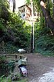
Home on Palo Colorado Road
-

Location in California
-
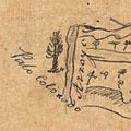
Detail from larger map, Diseño del Rancho San José y Sur Chiquito: Calif., circa 1835, showing the name "Arroyo de Palo Colorado".
-
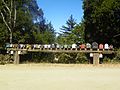
A large pulley hangs from a beam supporting a row of mailboxes on Palo Colorado Canyon Road.

