
Little Sur River facts for kids
Quick facts for kids Little Sur River |
|
|---|---|

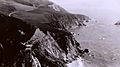
View of Little Sur River outlet from Highway 1
|
|

Location of the mouth of the Little Sur River in California
|
|
| Country | United States |
| State | California |
| Region | California Central Coast |
| County | Monterey County |
| Physical characteristics | |
| Main source | Ventana Double Cone 4,853 ft (1,479 m) 36°17′49″N 121°42′49″W / 36.29694°N 121.71361°W |
| River mouth | Pacific ocean 0 ft (0 m) 36°20′05″N 121°53′22″W / 36.33472°N 121.88944°W |
| Length | 14.3 mi (23.0 km) |
| Basin features | |
| Tributaries |
|

The Little Sur River is a river located on the Central Coast of California. It is about 25.4-mile (40.9 km) long. The river and its main branch, the South Fork, collect water from an area of about 40 square miles (100 km2). This area is part of the Big Sur region, where the Santa Lucia Mountains rise steeply from the Pacific Ocean.
Both the South Fork and North Fork of the river start in the Ventana Wilderness. Some parts of the North Fork are on land owned by the Granite Rock Company. The North and South forks join together about 2 miles (3.2 km) from the coast. From there, the river flows into the Pacific Ocean. The river's deep canyons and high ridges are home to rare plants and animals. These include the Santa Lucia fir and old-growth redwood trees.
Contents
River Environment
River Protections
In 1973, California recognized the Little Sur River as special. It was valued for its beautiful scenery, fish, wildlife, and outdoor fun. To keep it "free-flowing and wild," the state added it to the California Protected Waterways System. Monterey County also helps protect the river. The river's mouth is surrounded by private land, so people cannot easily access it. This helps protect the area.
Wildlife in the River Area
The Little Sur River area is home to many animals. You might find mountain lions, bears, deer, foxes, coyotes, and wild boars here. The upper parts of the river are very natural and untouched. This is because they are inside the Ventana Wilderness.
The river is very important for steelhead fish. It is considered the "most important spawning stream" for steelhead on the Central Coast. Steelhead are a type of trout that live in both fresh and saltwater. The steelhead in this area are listed as threatened. This means their numbers are low and they need protection. In 1991, it was estimated that fewer than 100 steelhead lived in the Little Sur River.
Plants and Trees
The river area is filled with many types of trees and plants. You can find coastal redwoods, Douglas firs, western sycamores, and bay laurel trees. There are also bigleaf maples and tanbark oaks. Near the river, you'll see alder trees, poison oak, and thimbleberry bushes.
Higher up the slopes, the land is covered in chaparral. This includes plants like coyote bush, ceanothus, chamise, manzanita, sagebrush, and bush lupine. Some open grassy areas have black oak and canyon live oak trees.
The Little Sur River watershed has some of the most amazing uncut coastal redwood trees in Big Sur. Some of these trees are over 200 feet (61 m) tall. It also has the tallest Douglas fir trees on the Central Coast, reaching up to 150 feet (46 m). A very rare tree, the Santa Lucia fir, grows on Skinner's Ridge. It is known as "the rarest and most unusual fir in North America."
River Geology
The river flows through deep, narrow canyons. The land is mostly steep and rocky. Several fault lines cross the river's path. These include the Sur and Palo Colorado faults. The river mostly flows west, which is different from other rivers in this region.
The north and south forks of the river flow around Pico Blanco. This mountain is special because it has a white limestone top. You can see it from Highway 1. The native Esselen people believed this mountain was sacred. They thought all life came from it. They also believed that three animals—the eagle, coyote, and hummingbird—survived the Great Flood on top of the mountain. These animals then created the world.
Weather in the Area
The Little Sur River area has hot, dry summers and mild, rainy winters. This is because Pico Blanco helps block the coastal fog. Temperatures usually range from 50 °F (10 °C) to 65 °F (18 °C). The area gets about 10 to 50 inches (250 to 1,270 mm) of rain each year. Most of the rain falls in winter. Heavy spring rains have caused mudslides in the past. These slides sometimes closed roads near the Camp Pico Blanco.
River Branches
The Little Sur River starts near the Ventana Double Cone. It then flows all the way to the Pacific Ocean. The upper part of the river's watershed is in the Ventana Wilderness. This wilderness is part of the Los Padres National Forest. The rest of the land, closer to the coast, is privately owned. More rain falls at higher elevations in Big Sur.
The main river is also called the North Fork. It is fed by several smaller creeks. These include Skinners Creek, Ventana Creek, Comings Creek, and Puerto Suelo Creek. The North Fork mostly flows over granite rock.
The South Fork of the river also flows over granite rock. Some parts have limestone and marble rock. The river has worn away the limestone and marble in places. This means the river sometimes flows underground. Tributaries on the South Fork include Rocky Creek, Turner Creek, Bixby Creek, Mill Creek, and Lachance Creek. There are no man-made dams on the South Fork. However, a 12 feet (3.7 m) waterfall about 11 miles (18 km) upstream stops steelhead fish from swimming further.
Camp Pico Blanco
Camp Pico Blanco is a Boy Scout camp located on the North Fork of the Little Sur River. It is about 793 feet (242 m) above sea level. Smaller creeks like Jackson Creek and Pine Creek flow into the river near the camp. The camp area has different natural habitats. These include redwood forests, woodlands, and aquatic areas.
The camp is reached by a narrow road called Palo Colorado Road. This road is about 7.6 miles (12.2 km) from the coast. Some redwood trees near the camp were planted between 1910 and 1921.
Camp Dam
There is a small, seasonal dam on the North Fork of the river at Camp Pico Blanco. It is an 11 feet (3.4 m) high concrete dam. It was built in 1953 to create a small reservoir for recreation. This reservoir is about 2 acres (0.81 ha) in size.
In 2002, there were concerns about the dam affecting steelhead fish. The National Marine Fisheries Service found that filling the dam might have harmed steelhead. To fix this, the Boy Scout council built a special fish ladder. This ladder helps the steelhead swim past the dam. It cost about $1 million to build.
River History
The Little Sur River area has always had very few people living there. The land is steep, rocky, and hard to reach. This made it difficult for people to live there for a long time.
Esselen People
The first people to live in this area were the Esselen American Indians. They moved around with the seasons to find food. In winter, they lived near the coast and gathered mussels and abalone. In summer and fall, they moved inland to collect acorns from oak trees.
A large rock with many deep holes, called a bedrock mortar, can be found near the camp. The Esselen people used these holes to grind acorns into flour. Pico Blanco mountain was very important to the Esselen people. They believed it was a sacred place where all life began.
When the Spanish missions came to California, many Esselen people were forced to live at the missions. They often got sick and died. Some Esselen people may have escaped into the mountains to avoid the missions.
Early European Settlers
After California became part of the United States, some brave settlers came to the Big Sur region. They were looking for free land. These settlers included William F. Notley, who settled near Palo Colorado Canyon in 1891.
Notley started harvesting tanoak bark from the canyon. This was a valuable product at the time. The bark was used to make tannic acid, which was needed for the leather tanning industry. Notley built a special landing at the mouth of the Palo Colorado River. The bark was brought out by mules or sleds and loaded onto ships.
Travel in the area was very difficult. The roads were rough and dangerous. They often closed in winter. It took many hours to travel even short distances. The Big Sur Coast Highway was completed in 1937. This made it much easier to reach the Big Sur coast.
National Forest
In the early 1900s, land in the Little Sur River watershed became part of the Los Padres National Forest. This was done to protect the area's natural beauty. Some private landowners, including tanning companies, still owned land within the forest.
Later, newspaper publisher William Randolph Hearst bought much of the land along the Little Sur River. He wanted to protect the redwood trees. In 1921, his company bought about $50,000 worth of land from the tanning companies.
Images for kids
-
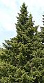
A Santa Lucia fir specimen in the Regional Parks Botanic Garden, Berkeley, California
-
Bixby Landing in 1911. Similar landings were built to load goods onto ships.
-
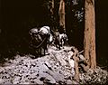
Harvesting Tanbark Oak bark in Big Sur around 1900. The bark was used to cure leather.
-
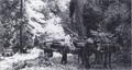
Cowboy Roy Bixby leading pack mules through the redwoods in Palo Colorado Canyon in 1932.
-
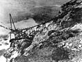
Bixby Canyon Bridge under construction in 1932.


