Pico Blanco facts for kids
Quick facts for kids Pico Blanco |
|
|---|---|

Pico Blanco
|
|
| Highest point | |
| Elevation | 3,694 ft (1,126 m) NAVD 88 |
| Geography | |
| Parent range | Santa Lucia Mountains |
| Topo map | USGS Big Sur |
| Climbing | |
| Easiest route | Trail hike |
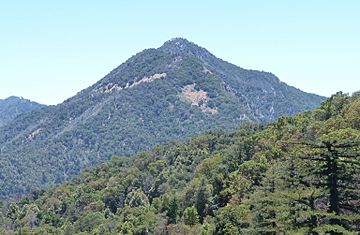
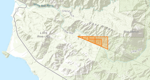
Pico Blanco is a special mountain peak located along the beautiful coast of Big Sur, California. It's part of the Santa Lucia Range within the Los Padres National Forest. The Little Sur River and its smaller streams almost completely surround the mountain.
This mountain is famous for its very pure limestone, a type of rock. A company called Graniterock owns the peak and about 2,800 acres around it. Part of its lower slopes belongs to the El Sur Ranch. The Old Coast Road, built long ago, winds along its side. From the top of Pico Blanco, hikers can see other amazing peaks like Ventana Double Cone and Cone Peak.
The Esselen people, who are Native Americans from this area, believed Pico Blanco was a sacred mountain. They thought all life began there. According to their legends, the world was once covered by a huge flood. Only the very top of Pico Blanco stayed above the water. Some stories say an eagle, coyote, and hummingbird survived the flood. Another version mentions an eagle, crow, raven, hawk, and hummingbird. A magical feather from the eagle was planted in the ocean, making the waters go down and creating the world again.
Contents
History of Pico Blanco
In 1911, a traveler named J. Smeaton Chase saw Pico Blanco while riding a horse along the coast. He wrote that the mountain looked "strangely white, almost as though it were snow-covered."
Alfred Clark's Search for Silver
Alfred King Clark was an English-born soldier who fought in the Civil War. He came to the United States in 1851. Clark built a home near the Little Sur River. A local story says that Native Americans used to bring high-quality silver ore from the wilderness near the river for Spanish soldiers. The Native Americans always went alone, so the Spanish never found the silver's location.
Clark reportedly became friends with one of the last living members of the Esselen tribe. When the elder was near death, they told Clark about a silver mine near the Little Sur River. Clark started looking for the mine around 1900. He claimed six pieces of land in 1906.
When he found signs of the mine, he got financial help from a partner in San Francisco. Clark started digging a tunnel. After months of hard work with no silver, his partner stopped helping. Clark kept going, sometimes working as a ranch hand. He would disappear for months, becoming a local legend. People thought he was a bit crazy. His "Silver King" mine shaft went 15 feet into the mountain, then dropped 20 feet, with other tunnels branching off.
J. Smeaton Chase also met Clark and described him as an "original" who lived alone in a cabin. Clark talked a lot about minerals and had a unique theory about them. He said an old Indian woman had given him a "map" that helped him. He claimed he could find wealth anytime but didn't care about money.
Al Geer and his family became friends with Clark and took care of him as he got older. Clark even got to take his first and only plane ride over his property when he was in his 90s. Before he died in 1932, Clark gave his land and home to Al Geer.
Clark told Geer that he never found silver. But he said that while digging his mine, he found a secret underground chamber. He described it as having several rooms with formations like icicles hanging from the ceiling (stalactites) and rising from the floor (stalagmites). He also saw flower-like structures on the walls, possibly gypsum flowers, which are often found in limestone caves. He mentioned an underground stream with white fish.
Clark also found a large room with a dirt floor and well-used mortar holes, which are hollows used for grinding. The walls had drawings of "elephants with long shaggy hair and curly teeth" and "cats with long sharp teeth." In 2010, parts of a Columbian mammoth with hair still attached were found near Castroville, California, not far from Pico Blanco.
Clark said he sealed the entrance to the chamber. The Geer family later moved into Clark's house. When Geer finally found the mine entrance, the tunnel had caved in, and he couldn't reopen it. No modern proof of Clark's amazing cavern has been found. Clark's old home and land are now owned by Graniterock.
Surveying the Mountain
The top of Pico Blanco was used as a special point by a survey team from the U.S. Coast & Geodetic Survey. This group started working around 1931 to update maps of the California Central Coast, where many ships had crashed. Getting to the peak was a six-and-a-half-hour hike from the coast. The survey teams often had to wait for hours for the fog to clear before they could make their measurements.
What's in a Name?
The name Pico Blanco means 'white peak' in the Spanish language. The white limestone rock on the mountain's peak is easy to see from far away along the coast.
Hiking and Camping
Visitors can usually hike from Bottchers Gap to Camp Pico Blanco on the Little Sur River. It's about a 7-mile hike. From the Boy Scout camp, hikers can take a trail that climbs Launtz Ridge. This trail leads to U.S. Forest Service campgrounds, including Pico Blanco Campground.
In 2016, the Soberanes Fire burned through the area, damaging roads and trails. Heavy rains afterward caused more damage. As of 2020, some roads and trails were still closed. Hikers can still get to the Little Sur Trail from the Old Coast Road. It's about a 5-mile hike to Pico Blanco Camp. However, this trail from the Old Coast Road can be very difficult to pass.
Limestone Deposits
Mount Pico Blanco has a very large deposit of high-quality limestone. This limestone is so pure it can be used in medicines, cosmetics, food, and to make clear glass. It's also a key ingredient in concrete. This is the only high-quality limestone deposit on the Pacific Coast (outside Alaska) that is close to the ocean for easy shipping. Experts believe there are hundreds of millions to a billion tons of limestone here. It's thought to be the largest deposit in California and west of the Rocky Mountains.
The Granite Rock Company bought about 2,800 acres, including the peak and the rights to the minerals, in 1963. Graniterock has special rights to cross the El Sur Ranch to reach the limestone. Part of the limestone deposit is inside the national forest, and part is outside, which makes managing the mining rights a bit complicated.
In 1980, Graniterock wanted to start a 5-acre quarry within the national forest land. The Forest Service approved the plan with some changes. However, the California Coastal Commission then said Graniterock also needed a coastal development permit. Graniterock argued that federal rules should be enough. The case went all the way to the Supreme Court of the United States. The Supreme Court decided that states like California could still require permits for activities on federal lands, especially in coastal areas. Graniterock still owns the property today.
 | Charles R. Drew |
 | Benjamin Banneker |
 | Jane C. Wright |
 | Roger Arliner Young |


