Bottchers Gap facts for kids
Quick facts for kids Bottchers Gap |
|
|---|---|

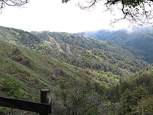
Ventana Wilderness from Bottchers Gap
|
|
| Location | Monterey County, California |
| Coordinates | 36°21′14″N 121°48′49″W / 36.3538516°N 121.8135641°W |
| Elevation | 2,060 feet (630 m) |
| Type | Trailhead, day use, campground |
| Land | Los Padres National Forest/Ventana Wilderness |
| Campsites | 12 |
| Facilities | Fire rings, restroom, picnic tables, BBQ grills |
| Water | None |
| Fee | $20 campsite; $10 parking day use |
| Fires | During fire season, permit required |
| Season | Year round (currently closed) |
| Established | 1951 |
| Website | Bottchers Gap Campround |
Bottchers Gap is a special place where you can spend the day, camp overnight, or start a hike. It's been closed since September 2016.
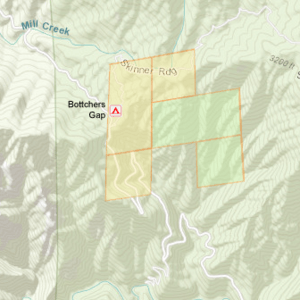
It's located about 7.6 miles from the Big Sur Coast Highway. You'll find it at the end of Palo Colorado Road. This spot is on the northern edge of the Los Padres National Forest and Ventana Wilderness. It sits between Mescal Ridge and Skinner Ridge. From Bottchers Gap, a private road leads 3.3 miles to Camp Pico Blanco. If you're up for a challenging 14.7-mile hike, you can reach the Ventana Double Cone from here. This makes it one of the most distant spots in the wilderness.
Contents
History of Bottchers Gap
Native American Life
Long ago, the Esselen people lived in this area. They gathered acorns from the mountain slopes nearby. The land was tough to live on, with steep, rocky areas and narrow canyons.
A large rock with many deep bowls carved into it can be found in Apple Tree Camp. This rock is called a bedrock mortar. The Esselen people used these holes for many generations to grind acorns into flour. By the early 1800s, most native people had been moved to Spanish missions. This left many villages in the Los Padres National Forest empty.
Early Settlers
The camp is named after John Gottfried Boettcher. He was a German immigrant who lived in a cabin here with his wife Pauline around 1885–1890. He received ownership of two pieces of land, one in 1888 and another in 1890.
Skinner Ridge and Skinner Creek are named after Benjamin R. Skinner. He settled land nearby with his wife Adeline in 1890. Turner Creek, north of Skinner's land, was settled by George C. Turner in 1890. Settlers could own land after living on it for five years. Or they could pay a small fee per acre after six months.
Forest Guard Station
In 1948, the Monterey Bay Area Council bought 1,445 acres of land. This land was on the North Fork of the Little Sur River. At that time, Palo Colorado Road ended at a spot called "The Hoist." This name came from how steep the road was. Wagons carrying wood had to be hoisted up with ropes and oxen.
The council worked with the United States Army Corps of Engineers. They extended the road 3.4 miles to Bottchers Gap. Then they added another 3.3 miles to the future site of Camp Pico Blanco. The Boy Scout Council spent about $200,000 to build this road. The road to the Boy Scout camp goes through very steep hills. It has four sharp turns called switchbacks. The entire road to the camp was finished in the summer of 1951.
The USFS Bottchers Gap Guard Station was built in 1950. The Double Cone Trail was also built then. A forest patrolman would take supplies by mule twice a month. These supplies went to the fire lookout on the Ventana Double Cone during fire season.
Geology of the Area
Bottcher's Gap sits in a dip between Mescal Ridge and Skinner Ridge. This dip was formed by the Palo Colorado fault. On the east side of the fault, the ground is mostly hard rock called quartz diorite. On the west side, it's mostly schist and gneiss, which are metamorphic rocks. The north fork of the Little Sur River flows along this fault for about 1 mile. Then it turns west towards the coast.
Campground Facilities
The campground is 2,060 feet high. It's located in a low area between two ridges. You'll find oak and Madrone trees here. There are 12 campsites, each with a fire ring.
Camp One, a parks management company, runs the camp. A manager usually lives on site. You don't need reservations to camp here. Camp One charges $20.00 per night for a single family site. This includes up to 6 people and 1 vehicle. It's $10.00 for each extra person per night. There's also a $10.00 charge for extra vehicles, up to two. The fee for just visiting during the day is $10.00 per vehicle. Camp One greatly increased fees when they took over management. In 2013, camping was only $5 for parking and day use.
There used to be a water system fed by a tank. But it wasn't kept up and can't be used anymore. Visitors must bring their own water. You can get good views of the Ventana Double Cone and Pico Blanco from here. The Skinner Ridge Trailhead (#1E04) is on the north side of the campground. This trail goes over Devil's Peak and through several other camps. The entrance to Palo Colorado Road is 11.4 miles south of Rio Road in Carmel Valley, California.
Closure of the Campground
The campground closed after the Soberanes Fire started on July 22, 2016. Campers left a fire unattended, which caused the blaze. The fire quickly spread through Palo Colorado Canyon. It destroyed 57 homes and 11 other buildings in the area.
The next winter, Rocky Creek washed out the road. More landslides and slip-outs also closed the road. Monterey County has stated it does not have enough money to fix the road.
 | Janet Taylor Pickett |
 | Synthia Saint James |
 | Howardena Pindell |
 | Faith Ringgold |


