Carmel Valley Village, California facts for kids
Quick facts for kids
Carmel Valley Village
|
|
|---|---|
|
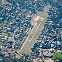
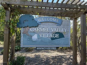
From top down, left to right: Carmel Valley Village panoramio; Carmel River; Carmel Valley Airport; Carmel Valley Village sign
|
|

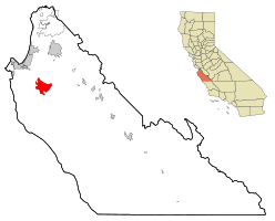
Location in Monterey County and the state of California
|
|
| Country | |
| State | |
| County | Monterey |
| Founded as Airway Village | 1946 |
| Founded by | Byington Ford and Tirey L. Ford Jr. |
| Area | |
| • Total | 19.18 sq mi (49.7 km2) |
| • Land | 18.98 sq mi (49.2 km2) |
| • Water | 0.20 sq mi (0.5 km2) 1.02% |
| Elevation | 846 ft (258 m) |
| Population
(2020)
|
|
| • Total | 4,524 |
| • Density | 238.32/sq mi (92.02/km2) |
| Time zone | UTC-8 (PST) |
| • Summer (DST) | UTC-7 (PDT) |
| ZIP code |
93924 ("Carmel Valley")
|
| Area code(s) | 831 |
| FIPS code | 06-11324 |
| GNIS feature ID | 1867002 |
Carmel Valley Village is a small community in Monterey County, California. It's a "census-designated place" (CDP), which means it's a special area the government uses for counting people.
In 1946, two brothers, Byington Ford and Tirey L. Ford Jr., started developing this area. They planned it to include an airport, shops, and homes. The population of Carmel Valley Village was 4,524 people in 2020. This was a slight increase from 4,407 people in 2010.
Contents
History of Carmel Valley Village
Early Land Ownership
The land where Carmel Valley Village now stands was once part of a large Mexican land grant called Rancho Los Laureles. This grant covered about 6,625 acres (26.8 km²) and was given out in 1839. It stretched along the Carmel River and the Carmel Valley.
Later, in 1882, a company called the Pacific Improvement Company (PIC) bought this land. In 1916, Samuel F.B. Morse took charge of the PIC. His job was to sell off the company's large land holdings.
Developing the Village
In 1919, Morse created the Del Monte Properties and bought the PIC. By 1923, the Del Monte Properties divided the land into smaller parts. A developer named Frank B. Porter bought 600 acres (2.4 km²). He later sold some of this land to Byington Ford.
Byington Ford and his wife, Marion, used 400 acres (1.6 km²) as their summer ranch. They called it Moon Trail Ranch.
Birth of Airway Village
In 1946, Byington Ford and his brother, Tirey Ford Jr., started a new project. They developed a community they called "Airway Village." This village was later renamed Carmel Valley Village.
It was designed to be a unique place for people who owned airplanes. The idea was that pilots could live very close to where they landed their planes.
Life in Airway Village
By 1947, Airway Village had many useful shops. These included the Airway General Store, a barbershop, a drug store with a soda fountain, and a beauty shop. There was also a bar called the Stirrup Cup and a liquor store called the Grapevine.
All these places were close to the Airpark. They were decorated to look like a charming Mexican village. An artist named Bruce Ariss painted murals on the stores to give them a Spanish village feel.
The Airpark and Its Changes
The Ford brothers built the Carmel Valley Airfield for plane owners. They wanted people to be "at home a minute or two after getting out of their planes." Tirey Ford even built a special "hangar house" near the airfield. This was a house with a connected airplane hangar, meant to be an example for future airborne communities.
After World War II, it became clear that not everyone would own a plane. So, Byington Ford changed his plans. He started selling land to both plane owners and people just looking for a home. He created ranch-style homes on 1 to 3-acre (0.4 to 1.2 ha) plots. He also imagined homes on hillsides where residents could watch planes land.
During World War II, the airfield was used by military planes. It served as a backup landing spot for planes flying from Watsonville and King City. A clubhouse built for the Airpark later became part of the Blue Sky Lodge, which is still open today.
Geography and Nature
Carmel Valley Village is located in the northern part of Monterey County. It is about 13 miles (21 km) east-southeast of Carmel-by-the-Sea. It is also about 16 miles (26 km) southeast of Monterey.
River and Surrounding Areas
The community includes the main part of Carmel Valley on one side of the Carmel River. It also includes the community of Robles del Rio on the other side of the river. The Carmel River flows northwest through the area and eventually reaches the Pacific Ocean.
Local Ecosystems
The area around Carmel Valley Village has several natural environments. These include California oak woodlands, areas with trees along rivers (riparian woodlands), and chaparral (dense shrubs). You can also find grasslands and savannas. A common tree here is the Coast Live Oak (Quercus agrifolia).
Garland Ranch Regional Park
The Garland Ranch Regional Park is a beautiful natural space in the area. It is managed by the Monterey Peninsula Regional Park District. The park is located at 700 West Carmel Valley Road.
Climate in Carmel Valley
Carmel Valley Village has a warm-summer Mediterranean climate. This means it has warm, dry summers. Average monthly temperatures are usually below 71.6°F (22°C). However, during heat waves, temperatures can reach the upper 70s to over 100°F (38°C), especially further inland.
Population Information
| Historical population | |||
|---|---|---|---|
| Census | Pop. | %± | |
| 2000 | 4,700 | — | |
| 2010 | 4,407 | −6.2% | |
| 2020 | 4,524 | 2.7% | |
| U.S. Decennial Census | |||
In 2020, the population of Carmel Valley Village was 4,524 people. This was a small increase from the 4,407 people counted in 2010.
Education for Students
Most of Carmel Valley Village is part of the Carmel Unified School District. This district includes Carmel High School. A smaller part of the community is in the Washington Union Elementary School District and the Salinas Union High School District.
Notable People from Carmel Valley Village
Several well-known people have lived in Carmel Valley Village:
- Beverly Cleary, a famous author of children's books.
- Doris Day, a popular singer, actress, and animal activist.
- Jesse Metcalfe, an actor known for his role in the movie John Tucker Must Die.
See also
 In Spanish: Carmel Valley Village para niños
 | Misty Copeland |
 | Raven Wilkinson |
 | Debra Austin |
 | Aesha Ash |


