Palomino, Colombia facts for kids
Quick facts for kids
Corrigimiento de Palomino, Dibulla
|
|||
|---|---|---|---|
|
City
|
|||
|
|||

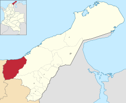
Location of the municipality of Dibulla in La Guajira Department.
|
|||
| Country | |||
| Region | Caribbean | ||
| Department | La Guajira | ||
| Recognized | 1984 | ||
| Elevation | 2 m (7 ft) | ||
| Population
(2005)
|
|||
| • Total | 3,900 | ||
| Time zone | UTC-05 (Colombia Standard Time) | ||
| Website | dibulla-laguajira.gov.co | ||
| *Although originally founded in 1525, Palomino was officially created according to Acuerdo No. 01 de enero 26 de 1984 | |||
Palomino is a small, sunny town located on the Caribbean coast of Colombia. It is part of the Guajira region. The town is about 70 kilometers from Santa Marta and 90 kilometers from Riohacha. Palomino is known for its beautiful beaches and natural surroundings.
Contents
Exploring Palomino's Location
Where is Palomino?
Palomino is located in the Dibulla area of the Guajira department. It sits only 2 meters above sea level, right by the Caribbean Sea. Palomino is one of five towns that make up the Dibulla area.
Mountains and Rivers Nearby
The town is nestled at the foot of the Sierra Nevada de Santa Marta mountains. These mountains are special because they are separate from the main Andes mountain chain in Colombia. UNESCO has even called the Sierra Nevada a Biosphere Reserve. It is the world's highest coastal peak, reaching 5,775 meters above sea level. This is only 42 kilometers from the Caribbean coast! The Sierra Nevada covers about 17,000 square kilometers and is the source of 36 rivers.
Palomino is bordered by the Caribbean Sea to the north. To the south, it borders the area of San Juan Del Cesar. To the east is the town of Mingueo, and to the west is the Magdalena department. Palomino is also very close to the border with Venezuela.
Palomino's Weather
Palomino has a tropical climate. This means it is warm all year round. From December to May, there is little rain. The wet season runs from May to November, bringing slightly warmer temperatures and heavy rain at times.
| Climate data for Palomino | |||||||||||||
|---|---|---|---|---|---|---|---|---|---|---|---|---|---|
| Month | Jan | Feb | Mar | Apr | May | Jun | Jul | Aug | Sep | Oct | Nov | Dec | Year |
| Mean daily maximum °C (°F) | 32.1 (89.8) |
32.8 (91.0) |
33.0 (91.4) |
32.9 (91.2) |
32.8 (91.0) |
32.9 (91.2) |
33.7 (92.7) |
33.5 (92.3) |
32.6 (90.7) |
31.6 (88.9) |
31.7 (89.1) |
31.8 (89.2) |
32.6 (90.7) |
| Daily mean °C (°F) | 27.3 (81.1) |
27.9 (82.2) |
28.3 (82.9) |
28.7 (83.7) |
28.8 (83.8) |
29.0 (84.2) |
29.3 (84.7) |
29.2 (84.6) |
28.5 (83.3) |
27.8 (82.0) |
27.8 (82.0) |
27.3 (81.1) |
28.3 (83.0) |
| Mean daily minimum °C (°F) | 22.6 (72.7) |
23.1 (73.6) |
23.7 (74.7) |
24.5 (76.1) |
24.9 (76.8) |
25.2 (77.4) |
25.0 (77.0) |
24.9 (76.8) |
24.4 (75.9) |
24.1 (75.4) |
23.9 (75.0) |
22.9 (73.2) |
24.1 (75.4) |
| Average rainfall mm (inches) | 27 (1.1) |
23 (0.9) |
29 (1.1) |
100 (3.9) |
105 (4.1) |
191 (7.5) |
123 (4.8) |
172 (6.8) |
339 (13.3) |
452 (17.8) |
373 (14.7) |
112 (4.4) |
2,046 (80.4) |
Palomino's Economy and Jobs
Local Farming
Most people in Palomino work as small farmers. They grow crops like plantains, yuca, ñame, corn, and mango. These are mostly for their own families to eat. They also grow small amounts of other fruits and vegetables in home gardens. Not much is grown to sell in stores.
Fishing Activities
Fishing is a popular activity in Palomino, but it is not the main way people earn money. Only a small number of people are fishermen. They catch fish like Snapper, Mero, Mackerel, and Sea Bass.
Raising Animals
People in Palomino also raise animals, mainly cattle, for milk and meat. Some families herd goats. Growing grass for the animals can be hard because of the changing weather. Farmers often do not use modern methods like fertilizers or vaccines for their animals. This means they produce less and earn less money.
Handmade Crafts
Local artists in Palomino create many beautiful handmade items. These include stone sculptures and pottery figures. They also make straw hats with traditional designs, fans, and baskets. Some crafts are animal figures made from coconuts. Others are religious items or tools made from bull horns.
Tourism and Fun Activities
Palomino is a beautiful place with exotic jungle landscapes and quiet, white beaches. It attracts many backpackers and travelers. The town is close to the Sierra Nevada National Park and an Indigenous Reserve area.
A very popular activity is tubing down the Palomino River. You can float along the river and enjoy the scenery. In recent years, more restaurants, cafes, and hostels have opened up for visitors.
Other fun places to visit include:
- Forest Bathing Resort
- Reserva Natural El Matuy, Cabins of Ernesto Uribe
- Camping Las Gaviotas
- Mountains of San Salvador
- Playa (Beach) Larga
- Finca(Farm) La Mello y La Terraza of Ernesto Samper
- La Casa de Guadua Eco Hostal
- Turtle Reserve
- La Boca de Palomino
- Madreviejas and Wetlands of Palomino, Canillal, Boquita del Medio, Limoncito, San Salvado, and La Taguara
- Palomino River
- Hostel Ematur
- The Snow Peaks
- Peaks (Pico Colon, Simon Bolivar, and Reina)
Who Lives in Palomino?
Population and Diversity
In 2000, Palomino had about 3,900 people. Nearly 30 percent of the people were children aged 1 to 15. The town is home to many different groups of people. Most residents are Mestizo (people of mixed European and Indigenous heritage). There are also Afro-Colombians, Andean farmers, and traditional indigenous groups.
Indigenous Communities
The Kogi and Arhuaco Indians live in the Sierra Nevada Mountains. They often visit Palomino to collect sea snails or trade their handmade goods. They also perform special rituals on the beach. There are places along the coast that these indigenous groups consider sacred. They perform rituals there as part of their "Linea Negra" (Black Line) beliefs, which the Colombian government now recognizes. The Kogi people live in different areas of the valleys near rivers like Tapias and Palomino.
Colombia is a country with many different ethnic groups. These include people of European, Indigenous, and Afro-descendent backgrounds.
Palomino's Culture
Palomino has a rich and colorful culture because of its many different ethnic groups. The traditions of these groups mix together, especially in folk dance and music. People in Palomino also love football, which brings them together. The local food is mainly based on Caribbean cooking traditions.
In the past, Palomino used to celebrate its patron saint, San Isidro Labrador, with special church services, fireworks, and folk dances. However, this tradition has become less common over time. Community leaders hope to bring back these important cultural and religious events.
Religious Celebrations
Here are some of the religious celebrations in Palomino:
- San Isidro Labrador (Patrón) - May 15
- Santa Rita de Cassia - May 22
- San Antonio de Padua - June 13
- Virgen del Carmen - July 16
- Divino Niño - September 3
- San Rafael de Arcángel - October 24
- San Martín de Loba - November 11
- Niño Jesús - December 16–25
Town Layout and Buildings
How Palomino is Built
Palomino is laid out in a long line, stretching from the south (near San Juan Del Cesar) to the north (by the Caribbean Sea). A main highway, Troncal del Caribe, runs through the town, dividing it into two parts. The town is about 300 meters from the beach and 500 meters from the Palomino River. The town square faces the sea, and the culture house faces the Sierra Nevada Mountains.
Homes in Palomino
Palomino's buildings show a mix of Spanish style and modern influences. The first modern houses appeared between 1940 and 1950. At that time, fishermen started living in areas where the Kogi indigenous tribe used to live.
Like many coastal towns in Colombia, Palomino has a grid pattern around a town square. Important buildings like the Catholic church, a school, a police station, and a health center are located around this square. The first houses were single-family homes made of wood with palm leaf roofs. Over time, they changed to be built with cement and brick. Today, very few houses in Palomino are made of wood.
When the Troncal del Caribe highway was built, the town started to grow along it. This divided the town, with newer homes closer to the highway and older ones closer to the sea. This created different areas within the town. Many houses are small, one-story homes on narrow plots of land with a patio. Since the 1970s, most houses are built with concrete and metal roofs. They often have very small windows, which means they do not get much fresh air.
Public Services in Palomino
Water and Waste Management
Many families in Palomino do not have access to clean drinking water. People often have to get water from rivers and springs, which can be polluted. This can lead to health problems. Only a small part of the population has water supplied to their homes from a well. Other neighborhoods get water from small tanks that collect rainwater, or from other wells.
The town does not have a proper sewage system. This means wastewater is not treated and can cause serious health issues. Garbage collection is also a challenge. There is only one truck for six towns, and many roads are difficult to access. This means garbage is often left on the streets, burned, or dumped in rivers and the sea.
Other Important Services
- Energy: Electricity is not always available, and many homes do not have it. Even those with electricity often experience daily power outages.
- Gas: Most homes have residential gas for cooking, which is a good service. Some people still use wood or coal.
- Education: Palomino has two rural schools and two schools in the indigenous area. However, the school buildings are not always good, and some teachers may not be fully trained. Many children struggle with reading and writing.
- Health: There is one health center in Palomino for about 3,900 people. It has a doctor, a nurse, and a dentist who visits weekly. The center is being improved to offer more services for children and pregnant women. There are also three pharmacies in town.
- Roads: The main road in town is unpaved and in poor condition. Roads to neighborhoods are often dirt roads that are hard to use. A bridge is needed over the San Salvador River to make it easier to cross during floods.
- Recreation: The town square has a small park and a football field for fun activities. There is also a tourist center called EMATUR.
- Administrative: Palomino has a local police station.
See also
 In Spanish: Palomino (La Guajira) para niños
 | Georgia Louise Harris Brown |
 | Julian Abele |
 | Norma Merrick Sklarek |
 | William Sidney Pittman |


