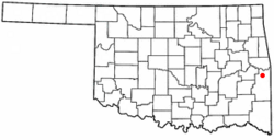
Panama, Oklahoma facts for kids
Quick facts for kids
Panama, Oklahoma
|
|
|---|---|

Location of Panama, Oklahoma
|
|
| Country | United States |
| State | Oklahoma |
| County | Le Flore |
| Area | |
| • Total | 2.28 sq mi (5.92 km2) |
| • Land | 2.26 sq mi (5.85 km2) |
| • Water | 0.03 sq mi (0.07 km2) |
| Elevation | 453 ft (138 m) |
| Population
(2020)
|
|
| • Total | 1,269 |
| • Density | 561.75/sq mi (216.86/km2) |
| Time zone | UTC-6 (Central (CST)) |
| • Summer (DST) | UTC-5 (CDT) |
| ZIP code |
74951
|
| Area code(s) | 539/918 |
| FIPS code | 40-56900 |
| GNIS feature ID | 2413104 |
Panama is a town located in Le Flore County, Oklahoma, United States. It is part of the Fort Smith, Arkansas-Oklahoma Metropolitan Statistical Area. In 2010, the town had a population of 1,413 people. By 2020, the population was 1,269.
History of Panama
A post office was first opened in Panama, then known as Indian Territory, on January 14, 1898. At that time, Panama was part of Skullyville County within the Choctaw Nation. The Choctaw Nation was a self-governing Native American territory.
This town started as a place for coal miners. It was first called Red Town because the miners' homes were all painted red. No one is completely sure how the name "Panama" came about. Some people think it was inspired by the building of the Panama Canal. However, the town was already called Panama by 1898. This means the name would have come from the first, unsuccessful French attempt to build the canal, which happened between 1881 and 1889. The successful American effort didn't start until 1904.
In 1896, the Kansas City, Pittsburg and Gulf Railroad built a railway line through the area. This railway was later taken over by the Kansas City Southern Railway in 1900. A few years later, in 1903–1904, the Midland Valley Railroad built another railway line that crossed the first one. The town of Panama then moved to be right where these two important railway lines met. The Panama post office opened again on February 21, 1899, after a brief closure.
Coal mining continued to be important for Panama until the 1930s. The Ozark Coal and Mining Company had started operations there in 1898. However, many coal mines began to close down in the 1930s. A plant that treated wood with creosote opened in 1937, which helped provide some jobs for the former miners. The Panama Coal Company, which used a method called strip mining, closed down in 1977.
Geography of Panama
Panama is located about 9 miles (14 km) north of Poteau. You can find it along State Highway 59.
The United States Census Bureau reports that the town covers a total area of about 1.5 square miles (3.9 square kilometers). Only a very small part of this area, about 0.66%, is water.
Population and People
| Historical population | |||
|---|---|---|---|
| Census | Pop. | %± | |
| 1910 | 310 | — | |
| 1920 | 568 | 83.2% | |
| 1930 | 754 | 32.7% | |
| 1940 | 880 | 16.7% | |
| 1950 | 1,027 | 16.7% | |
| 1960 | 937 | −8.8% | |
| 1970 | 1,121 | 19.6% | |
| 1980 | 1,425 | 27.1% | |
| 1990 | 1,528 | 7.2% | |
| 2000 | 1,362 | −10.9% | |
| 2010 | 1,413 | 3.7% | |
| 2020 | 1,269 | −10.2% | |
| U.S. Decennial Census | |||
According to the census from 2010, there were 1,413 people living in Panama. These people made up 530 households and 364 families. The population density was about 903 people per square mile (348.6 people per square kilometer).
The average household in Panama had about 2.57 people. The average family size was about 3.12 people.
The population was spread out across different age groups. About 29.1% of the people were under 18 years old. About 14.93% were 65 years old or older. The average age in the town was 34 years.
See also
 In Spanish: Panama (Oklahoma) para niños

