Paracuellos de la Ribera facts for kids
Quick facts for kids
Paracuellos de la Ribera
|
|||
|---|---|---|---|

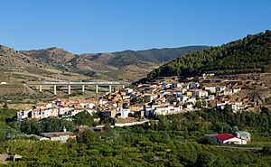
Panoramic view of Paracuellos de la Ribera
|
|||
|
|||
| Country | Spain | ||
| Autonomous community | Aragon | ||
| Province | Zaragoza | ||
| Comarca | Comunidad de Calatayud | ||
| Area | |||
| • Total | 14 km2 (5 sq mi) | ||
| Population
(2018)
|
|||
| • Total | 158 | ||
| • Density | 11.3/km2 (29.2/sq mi) | ||
| Time zone | UTC+1 (CET) | ||
| • Summer (DST) | UTC+2 (CEST) | ||
Paracuellos de la Ribera is a small town in Spain. It is located in the province of Zaragoza, which is part of the Aragon region. In 2018, about 158 people lived there.
This town sits at the bottom of the Sierra de Vicort mountains. It is also very close to a main road called Carretera Nacional N-II.
Contents
What is Paracuellos de la Ribera?
Paracuellos de la Ribera is a type of local area called a municipality. Think of it like a small community or town with its own local government. It is part of a larger area called a province, and then an even larger area called an autonomous community.
Where is Paracuellos de la Ribera located?
This town is found in the northeastern part of Spain. It's in the province of Zaragoza, which is known for its beautiful landscapes and history. The region of Aragon is one of Spain's 17 autonomous communities.
Mountains and Roads
The town is nestled at the foot of the Sierra de Vicort mountain range. This means it has a scenic view of the mountains. Being close to the Carretera Nacional N-II highway makes it easy to travel to and from the town. This highway connects many important places in Spain.
See also
 In Spanish: Paracuellos de la Ribera para niños


