Sierra de Vicort facts for kids
Quick facts for kids Sierra de Vicort |
|
|---|---|

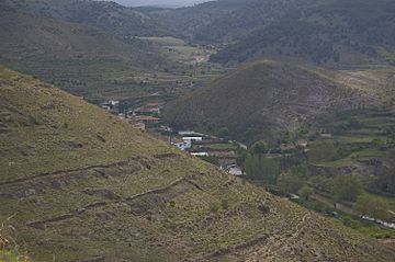
Sierra de Vicort in Huérmeda
|
|
| Highest point | |
| Peak | Pico del Rayo |
| Elevation | 1,420 m (4,660 ft) |
| Listing | List of mountains in Aragon |
| Geography | |
| Location | Comunidad de Calatayud, Campo de Daroca (Aragon) |
| Parent range | Iberian System |
| Geology | |
| Orogeny | Alpine orogeny |
| Age of rock | Paleozoic |
| Type of rock | Quartzite |
| Climbing | |
| First ascent | Unknown |
| Easiest route | Drive from El Frasno, Sediles, Mara, Tobed or Santa Cruz de Grío |
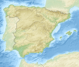
The Sierra de Vicort, also called Sierra de Vicor, is a mountain range in Spain. It is about 20 kilometers (12 miles) long. You can find it in the Aragon region, specifically in the areas of Comunidad de Calatayud and Campo de Daroca.
This mountain range runs from the northwest to the southeast. It is located southeast of another range called Sierra de la Virgen. The Jalón River valley separates these two mountain ranges. To the north of Sierra de Vicort is the Sierra de Algairén. A long valley, the Grio River Valley, lies between them. The Grio River starts in the Sierra de Vicort and flows into the Jalón River.

The highest point in the Sierra de Vicort is Pico del Rayo, which is 1,420 meters (4,659 feet) high. As the range goes southeast, it splits into two smaller ranges. These are the Sierra del Espigar (1,277 m high) and the Sierra de la Modorra (1,279 m high). The side of the range facing northeast is very steep. However, the southwestern slopes, which go down towards the Sediles and Mara areas, are much smoother.
A main road, Carretera Nacional N-II, crosses the northern part of the range near El Frasno. There are old Celtiberian ruins and artifacts in this area. The Celtiberians were ancient people who lived in Spain. Some people think the name "Vicort" itself comes from their language.
Plants and Animals of Sierra de Vicort
These mountains have many areas covered with trees. You will mostly see pine trees and different kinds of oak trees, like Quercus rotundifolia, Quercus pyrenaica, and Quercus faginea. Between the trees, there are also heath and broom plants. You can also find Calluna vulgaris shrubs, thyme, and Festuca grasses.
One special plant found here is Centaurea pinnata. This plant is an endangered species, meaning it is at risk of disappearing forever. During long dry periods, the southern parts of the Sierra de Vicort often have wildfires. These fires can cause a lot of damage.
Human Activities and History
People in some villages around the mountains still raise cattle in the traditional way. They let their animals graze on the dry grasslands. Many hunters also visit the Sierra de Vicort, especially on weekends.
There are also some old, mostly ruined towns in this range. One is Aldehuela de Santa Cruz, which is now a ghost town with no one living there. Another is Viver de Vicort, which has very few people left.
On Pico de Santa Brígida, which is 1,411 meters (4,629 feet) high, there is a weather radar antenna. This antenna is part of the Inogés military base. There is also a special place of worship for the Virgin Mary in the mountains. It is called the Ermita de Nuestra Señora de Jerusalen.
See also
- Sistema Ibérico
- Mountains of Aragon
- Comunidad de Calatayud
- In Spanish: Sierra de Vicort para niños
 | Bessie Coleman |
 | Spann Watson |
 | Jill E. Brown |
 | Sherman W. White |


