
Paranapanema River facts for kids
Quick facts for kids Paranapanema River |
|
|---|---|
 |
|

Map of the La Plata Basin, showing the Paranapanema River joining the upper Paraná River.
|
|
| Country | Brazil |
| State | São Paulo, Paraná |
| Physical characteristics | |
| Main source | Serra dos Agudos 910 m (2,990 ft) 24°51′S 48°10′W / 24.850°S 48.167°W |
| River mouth | Paraná River Brazil 233 m (764 ft) 22°39′31″S 53°5′15″W / 22.65861°S 53.08750°W |
| Length | 929 km (577 mi) |
| Basin features | |
| River system | Paraná River |
| Tributaries |
|
The Paranapanema River is a very important river in Brazil. Its name in Portuguese is Rio Paranapanema. This river forms most of the border between two Brazilian states: São Paulo and Paraná.
Contents
River's Journey
The Paranapanema River starts high up and flows down to a lower point. The difference in height from where it begins to where it ends is about 677 metres (2,221 ft). The river is quite long, stretching for about 929 kilometres (577 mi). It generally flows towards the west. Finally, it joins the Paraná River at a height of about 233 metres (764 ft) above sea level.
Where the River Starts
The river's source is in the Serra Agudos Grandes mountains. This area is in south-central São Paulo, about 100 kilometres (62 mi) from the Atlantic Ocean. The place where the river begins is protected by a large park called the Nascentes do Paranapanema State Park. This park was created in 2012 and covers an area of 22,269 hectares (55,030 acres).
River's Path Through States
From its source, the Paranapanema River flows only within the state of São Paulo. This continues until it meets the Itararé River. After that point, the Paranapanema River becomes the natural border between the states of Paraná and São Paulo.
Cleanest River in São Paulo
The Paranapanema is known for being the least polluted river in the state of São Paulo. This means its waters are cleaner compared to many other rivers in the region.
River's Slope
The Paranapanema River has a gentle slope for most of its length. On average, it drops about 61 centimeters for every kilometer it flows. This is a relatively small drop for such a long river.
The river can be divided into three main parts:
Lower Paranapanema
This part of the river goes from its mouth at the Paraná River up to the Grande Falls. This stretch is about 421 km long. Here, the river's slope is very gentle, dropping only about 29 centimeters per kilometer. The river can be very wide in this section, sometimes nearly 800 meters across.
Middle Paranapanema
The middle part of the river runs from the Grande Falls to where it meets the Apiaí-Guaçu River. This section is about 328 km long. Along this part, the river drops a total of 210 meters. However, its slope changes a lot because there are several dams built here for making electricity.
Upper Paranapanema

The upper part of the Paranapanema River starts from the Apiaí-Guaçu River and goes all the way to the river's source in the Serra de Agudos Grandes mountains. This section is about 180 km long. The slope here is quite steep, dropping about 150 centimeters for every kilometer. Many smaller streams flow into the Upper Paranapanema, making it bigger as it goes along. It also meets the Itapetininga River and the Apiaí-Guaçu River here.
Boating on the River
Boating is possible on the lower part of the Paranapanema River. You can navigate for about 70 km from where it joins the Paraná River up to the port of Euclides da Cunha. However, this journey can be a bit tricky. Under normal conditions, the water is at least 1.5 metres (4.9 ft) deep in this section.
There are some natural challenges that can make boating difficult or dangerous. These include hidden rocks, areas where the current is very slow, or places where the water is not deep enough. There are also parts with strong currents, wavy water, winding channels, and sand banks.
The large amounts of water stored in the Paranapanema's dams affect the river's flow in its middle section. However, this effect is much smaller in the lower part of the river, so it doesn't stop boats from using it.
Dams and Reservoirs
The Paranapanema River has eight dams and their large lakes (reservoirs). These dams are important for generating hydroelectric power, which is electricity made from moving water. Here is a list of the dams, starting from the one closest to the river's source and moving downstream towards the Paraná River:
| Dam Name | Reservoir Name | Power Generated | Reservoir Area |
|---|---|---|---|
| Hydroelectric Plant of Jurumirim | Reservoir of Jurumirim | 98 MW | 449 km² |
| Hydroelectric Plant of Chavantes | - | 414 MW | 400 km² |
| Hydroelectric Plant of Salto Grande | - | 74 MW | 12 km² |
| Hydroelectric Plant of Canoas II | - | 72 MW | 22.5 km² |
| Hydroelectric Plant of Canoas I | - | 81 MW | 30.85 km² |
| Hydroelectric Plant of Capivara | Reservoir of Capivara | 619 MW | 576 km² |
| Hydroelectric Plant of Taquaruçu | - | 526 MW | 80.1 km² |
| Hydroelectric Plant of Rosana | - | 353 MW | 220 km² |
Images for kids
-

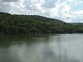
View of the river in the municipality of Paranapanema.
-
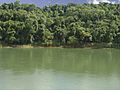
The river in Cerqueira César.
-
Border with Piraju.
-
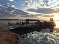
Ferry joining Paranapanema to Itatinga and SP-280.
-
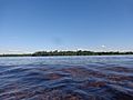
View of the river in the municipality of Salto Grande.


See also
 In Spanish: Río Paranapanema para niños
- Tributaries of the Río de la Plata
