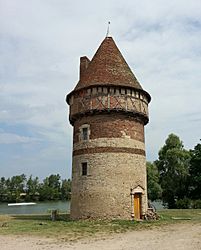
Paray-sous-Briailles facts for kids
Quick facts for kids
Paray-sous-Briailles
|
||
|---|---|---|
 |
||
|
||
| Country | France | |
| Region | Auvergne-Rhône-Alpes | |
| Department | Allier | |
| Arrondissement | Moulins | |
| Canton | Saint-Pourçain-sur-Sioule | |
| Intercommunality | Pays Saint-Pourcinois | |
| Area
1
|
22.18 km2 (8.56 sq mi) | |
| Population
(2008)
|
623 | |
| • Density | 28.088/km2 (72.75/sq mi) | |
| Time zone | UTC+01:00 (CET) | |
| • Summer (DST) | UTC+02:00 (CEST) | |
| INSEE/Postal code |
03204 /03500
|
|
| Elevation | 228–266 m (748–873 ft) (avg. 234 m or 768 ft) |
|
| 1 French Land Register data, which excludes lakes, ponds, glaciers > 1 km2 (0.386 sq mi or 247 acres) and river estuaries. | ||
Paray-sous-Briailles is a commune. It is found in the Allier department in the center of France.
Contents
About Paray-sous-Briailles
Paray-sous-Briailles is a small town in the heart of France. It is known as a "commune," which is like a local government area. This town is part of the Allier department.
Where is Paray-sous-Briailles?
This commune is located in central France. It is part of the Moulins arrondissement. An arrondissement is a type of administrative district. The town is also in the canton of Saint-Pourçain-sur-Sioule. A canton is another local division.
The town sits at an elevation of about 234 meters (768 feet). Its lowest point is 228 meters (748 feet). The highest point is 266 meters (873 feet). The total area of Paray-sous-Briailles is 22.18 square kilometers (8.56 square miles).
People and Community
In 2008, about 623 people lived in Paray-sous-Briailles. This makes it a small and quiet community. The people living there are called its population. The town has its own postal code, which is 03500.
How the Town is Run
Like all communes in France, Paray-sous-Briailles has a mayor. The mayor is the head of the local government. From 2008 to 2014, the mayor was Gilles Journet. The commune is also part of a larger group called "Pays Saint-Pourcinois." This group helps different towns work together.
See also
 In Spanish: Paray-sous-Briailles para niños
 | Madam C. J. Walker |
 | Janet Emerson Bashen |
 | Annie Turnbo Malone |
 | Maggie L. Walker |


