Paria Peninsula facts for kids
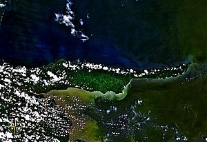
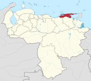
The Paria Peninsula (called Península de Paria in Spanish) is a large piece of land. It sticks out into the Caribbean Sea in northern Venezuela. This peninsula is located in the state of Sucre.

Contents
Exploring the Geography of Paria
The Paria Peninsula acts like a natural wall. It separates the Caribbean Sea from the Gulf of Paria. This land is part of a mountain range called the Serranía del Litoral. This range is also part of the larger Venezuelan Coastal Range, which is a section of the northern Andes mountains.
From the very tip of the Paria Peninsula, you can easily see the island of Trinidad. It's so close you can spot it with your own eyes!
Protecting Nature: Paria National Park
A special part of the Paria Peninsula is protected as a national park. This area is called Península de Paria National Park. It helps keep the natural beauty and wildlife of the peninsula safe for everyone.
Understanding the Paria Region
When people talk about the Paria Region, they are usually referring to a specific group of areas. These areas are six different municipalities within the state of Sucre. Think of municipalities like local districts or counties.
These six municipalities work together to form the Paria Region:
- Bermúdez Municipality – Its main town is Carúpano.
- Arismendi Municipality – Its main town is Río Caribe.
- Benítez Municipality – Its main town is El Pilar.
- Libertador Municipality – Its main town is Tunapuy.
- Mariño Municipality – Its main town is Irapa.
- Valdez Municipality – Its main town is Güiria.
See also
 In Spanish: Península de Paria para niños
- Gulf of Paria topics
- Venezuelan Coastal Range topics
 | Selma Burke |
 | Pauline Powell Burns |
 | Frederick J. Brown |
 | Robert Blackburn |


