Venezuelan Coastal Range facts for kids
Quick facts for kids Venezuelan Coastal RangeCaribbean Mountain System Maritime Andes |
|
|---|---|

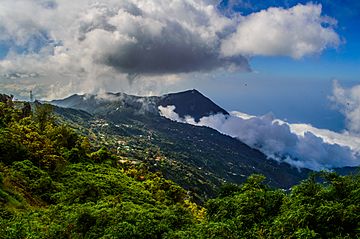
A view of Venezuelan Coastal Range from Galipán
|
|
| Highest point | |
| Peak | Pico Naiguatá |
| Elevation | 2,765 m (9,072 ft) |
| Geography | |
| Location | Yaracuy, Venezuela |
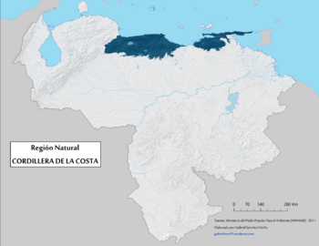
The Venezuelan Coastal Range is a system of mountains in Venezuela. It's also known as the Venezuelan Caribbean Mountain System. These mountains run along the central and eastern parts of Venezuela's northern coast.
This mountain range is like an extension of the famous Andes mountains. It's sometimes called the Maritime Andes because it's so close to the sea. The Coastal Range covers about 48,866 square kilometers. This makes it the fourth largest natural region in Venezuela.
Contents
Exploring the Geography of the Coastal Range
The Venezuelan Coastal Range is actually made up of two mountain chains. These chains run side-by-side, from east to west, right along the Caribbean Sea coast.
The Cojedes River marks the western end of the Coastal Range. It separates these mountains from the Cordillera de Mérida to the southeast. A large bay, located between Cape Codera and Cumaná, divides the Coastal Range into two main parts: an eastern section and a western section.
The Two Parallel Mountain Chains
In the eastern part of the Coastal Range, the two parallel mountain chains have special names.
- The chain running along the Caribbean coast is called the Serranía del Litoral.
- The chain to the south is known as the Serranía del Interior.
The area between these two mountain chains is very important. It includes places like Lake Valencia and the valleys where the big city of Caracas is located. The Tuy River also flows through the eastern end of this valley. This valley is the most populated area in all of Venezuela.
The Capital District, where Caracas is, sits in a valley. This valley is surrounded by two parts of the Serranía del Litoral. To the north, you'll find Cerro El Ávila and El Ávila National Park. To the south, there are smaller hills.
Both the Littoral and Interior mountain chains appear again further east. They stretch between Cumaná and the Gulf of Paria. Here, they form the eastern part of the Venezuelan Coastal Range. The Littoral chain creates the Araya Peninsula to the west and the Paria Peninsula to the east. It even extends across the water, through a strait called the Dragon's Mouths, to form the Northern Range on the island of Trinidad.
Understanding the Ecoregions
An ecoregion is a large area of land or water that contains a special group of natural communities and species. The Venezuelan Coastal Range has different ecoregions based on elevation and climate.
- Lower Elevations: The lower parts of these mountains are mostly covered by the La Costa xeric shrublands ecoregion. "Xeric" means dry, so these are areas with dry shrubs and plants. This ecoregion is part of the Deserts and xeric shrublands Biome.
- Araya and Paria Peninsulas: The very dry areas of the Araya and Paria peninsulas have their own ecoregion called the Araya and Paria xeric scrub. However, the higher, more mountainous parts of the Paria Peninsula are still part of the La Costa xeric shrublands. This Araya and Paria xeric scrub also includes Isla Margarita and reaches south to the mainland near Cumaná.
- Higher Elevations: At elevations from about 600 to 2,675 meters (around 1,970 to 8,776 feet), you'll find the Cordillera de la Costa montane forests. "Montane" means related to mountains, and these are humid, evergreen forests. They are part of the montane Tropical and subtropical moist broadleaf forests Biome. These forests appear in eleven separate areas across the high peaks of both the eastern and western parts of the range.
See also
 In Spanish: Cordillera de la Costa (Venezuela) para niños
 | Misty Copeland |
 | Raven Wilkinson |
 | Debra Austin |
 | Aesha Ash |


