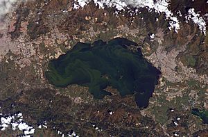
Lake Valencia (Venezuela) facts for kids
Quick facts for kids Lake Valencia / Lake TacariguaLago de Valencia / Lago Tacarigua |
|
|---|---|
 |
|
| Coordinates | 10°11′N 67°44′W / 10.183°N 67.733°W |
| Type | endorheic |
| Catchment area | 2,646 km2 (1,022 sq mi) |
| Basin countries | Venezuela |
| Surface area | 350 km2 (140 sq mi) |
| Average depth | 18 m (59 ft) |
| Max. depth | 39 m (128 ft) |
| Surface elevation | 410 m (1,350 ft) |
Lake Valencia (in Spanish, Lago de Valencia), also known as Lake Tacarigua, is a large lake in northern Venezuela. It's located in the states of Carabobo and Aragua.
Contents
Where is Lake Valencia?
Lake Valencia is the third largest lake in Venezuela. Only Lake Maracaibo and the Lake Guri reservoir are bigger.
The lake sits in one of the Aragua valleys. This valley is nestled between two mountain ranges. These ranges are part of the larger Venezuelan Coast Ranges system.
Lake Valencia is an endorheic lake. This means water flows into it, but it doesn't have a natural outflow to the sea. About 250 years ago, its water level dropped below its natural overflow point. Today, the lake's surface is about 410 meters (1,345 feet) above sea level. It is about 30 kilometers (19 miles) long. The lake covers an area of 350 square kilometers (135 square miles). Its deepest point is 39 meters (128 feet), and its average depth is 18 meters (59 feet). The lake has several small islands, and some of them have people living on them.
The area that drains into the lake, called its drainage basin, is 2,646 square kilometers (1,022 square miles). The most important river flowing into the lake is the Aragua River. Other rivers that feed the lake include the El Limón River, Guacara River, Güigüe River, Mariara River, and Turmero River. These rivers flow near cities like El Limón, Guacara, Güigüe, Mariara, and Turmero.
How Lake Valencia Changed Over Time
Lake Valencia was formed a very long time ago, about 2 to 3 million years ago. This happened because of cracks in the Earth's crust that blocked the Cabriales River. The lake has even dried up completely at different times in its long history.
In 1800, a famous explorer named Alexander von Humboldt visited the lake. He noticed that people living around the lake were growing crops. This farming was harming the lake's environment. Cutting down trees (deforestation) and taking water for irrigation caused the lake's water levels to drop a lot. Humboldt realized that human activities could change the environment. He even wrote about how cutting down forests could dry up springs and cause floods.
Since 1976, the water levels in Lake Valencia have actually gone up. This is because water from nearby river systems has been redirected into the lake. Now, the lake acts like a water storage area for nearby cities like Maracay and Valencia.
Lake Valencia's Environment
The lake faces problems from too much algae growing in its water. This happens because untreated wastewater from cities, farms, and factories flows into the lake. This pollution causes the lake to become overly rich in nutrients (a process called eutrophication). It also leads to contamination and makes the water saltier (salinization).
Even though Lake Valencia is in a beautiful spot between mountains, its poor water quality makes it hard for people to enjoy it for tourism or fun activities. Because of pollution and other changes made by humans, almost 60% of the native fish species in the lake disappeared between 1960 and 1990.
Some fish still live in the lake, like the diamond tetra, which is a popular aquarium fish. Two types of catfish, Lithogenes valencia and Pimelodella tapatapae, are found only in the Lake Valencia area.
There have been plans to clean up the lake. These plans include improving how wastewater is collected and treated.
See also
 In Spanish: Lago de Valencia para niños
 | Bayard Rustin |
 | Jeannette Carter |
 | Jeremiah A. Brown |


