
Patnitop facts for kids
Quick facts for kids
Patnitop
|
|
|---|---|
|
Hill Station
|
|

Patnitop in Winters
|
|

Patnitop
Location in Jammu and Kashmir

Patnitop
Location in India
|
|
| Country | |
| State | Jammu and Kashmir |
| District | Udhampur |
| Elevation | 2,024 m (6,640 ft) |
| Time zone | UTC+5:30 (IST) |
| PIN |
182142
|
Patnitop, also called Patni Top, is a beautiful hilltop place in the Udhampur district of Jammu and Kashmir, India. It's a popular spot for tourists. This lovely area is located on the Jammu-Srinagar National Highway, which is now part of National Highway 44. It's about 112 kilometers (70 miles) from Jammu. Patnitop is high up in the Himalayas, on a flat area called a plateau, about 2,024 meters (6,640 feet) above sea level. The Chenab River flows nearby, adding to its charm.
Patnitop Tunnel: A Winter Solution
During winter, Patnitop often gets a lot of snow. This snow can block the Jammu-Srinagar National Highway. When this happens, cars and trucks can get stuck for days. To solve this problem, a very long road tunnel was built.
How the Tunnel Helps Travel
This tunnel is called the Chenani-Nashri Tunnel, or sometimes the Patnitop Tunnel. It is India's longest road tunnel, stretching for 9.2 kilometers (5.7 miles). The tunnel starts near Chenani town and ends at Nashri village. It goes around Patnitop, which means drivers no longer have to go over the snowy mountain pass. This tunnel makes the journey from Jammu to Srinagar 31 kilometers (19 miles) shorter and much faster, especially in winter.
Gallery
-
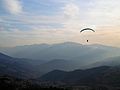
Paragliding at Patnitop
-
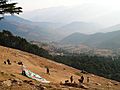
Dawariyai take off area at Patnitop
-
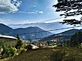
Patnitop Mountains


Images for kids
-
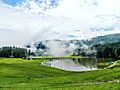
Sanasar Lake

