Pawling (village), New York facts for kids
Quick facts for kids
Pawling, New York
|
||
|---|---|---|
|
Village
|
||

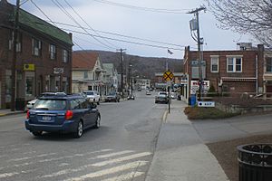
Downtown Pawling, east of the town center
|
||
|
||

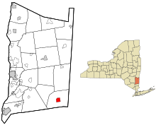
Location of Pawling, New York
|
||
| Country | United States | |
| State | New York | |
| County | Dutchess | |
| Town | Pawling | |
| Area | ||
| • Total | 1.95 sq mi (5.06 km2) | |
| • Land | 1.95 sq mi (5.06 km2) | |
| • Water | 0.00 sq mi (0.00 km2) | |
| Elevation | 463 ft (141 m) | |
| Population
(2020)
|
||
| • Total | 1,995 | |
| • Density | 1,020.98/sq mi (394.18/km2) | |
| Time zone | UTC-5 (Eastern (EST)) | |
| • Summer (DST) | UTC-4 (EDT) | |
| ZIP code |
12564
|
|
| Area code(s) | 845 | |
| FIPS code | 36-56814 | |
| GNIS feature ID | 0960006 | |
Pawling is a small village located in Dutchess County, New York. In 2020, about 1,995 people lived there. It's part of a larger area that includes cities like Poughkeepsie and New York City.
You can find the historic John Kane House, a special landmark, in the village. Pawling was even shown on TV! It was called Denning, New York, in the show Elementary. The village of Pawling is right in the middle of the larger Town of Pawling. It's located where two main roads, Routes 22 and 55, meet.
Contents
History of Pawling Village
The village of Pawling officially became a village in 1893.
Pawling is also famous for hosting the world's shortest St. Patrick's Day parade! This fun event happens every year on Broad Street. The parade route is only 223 feet long.
Where is Pawling Located?
Pawling is in the southeastern part of Dutchess County. Its exact location is 41°33′43″N 73°35′54″W / 41.56194°N 73.59833°W.
The United States Census Bureau says that the village covers a total area of about 1.95 square miles (5.06 square kilometers). All of this area is land.
How Many People Live in Pawling?
| Historical population | |||
|---|---|---|---|
| Census | Pop. | %± | |
| 1880 | 580 | — | |
| 1890 | 630 | 8.6% | |
| 1900 | 781 | 24.0% | |
| 1910 | 848 | 8.6% | |
| 1920 | 1,032 | 21.7% | |
| 1930 | 1,204 | 16.7% | |
| 1940 | 1,446 | 20.1% | |
| 1950 | 1,430 | −1.1% | |
| 1960 | 1,734 | 21.3% | |
| 1970 | 1,914 | 10.4% | |
| 1980 | 1,996 | 4.3% | |
| 1990 | 1,974 | −1.1% | |
| 2000 | 2,233 | 13.1% | |
| 2010 | 2,347 | 5.1% | |
| 2020 | 1,995 | −15.0% | |
| U.S. Decennial Census | |||
In 2000, there were 2,233 people living in Pawling. These people made up 919 households and 533 families. On average, about 1,096 people lived in each square mile.
The population was spread out by age. About 21.6% of the people were under 18 years old. About 22.2% were 65 years old or older. The average age in the village was 41 years.
Getting Around Pawling
Two important roads, State Routes 22 and 55, go through Pawling. Route 22 runs along the eastern side of Dutchess County. It also goes right next to Pawling's main business area.
You can also travel by train! The Metro-North Railroad has two train stations in Pawling. These stations are called Pawling and Appalachian Trail. You can take a train from here all the way to New York City on the Harlem Line.
There are also trails for walking and biking. The Maybrook Trailway goes south to Brewster. The WRS Dutchess Rail Trail goes west to Poughkeepsie. These trails are part of the larger Empire State Trail.
For local travel, Dutchess County Public Transit offers bus service. Route E can take you to Poughkeepsie.
See also
 In Spanish: Pawling (villa) para niños
 | Delilah Pierce |
 | Gordon Parks |
 | Augusta Savage |
 | Charles Ethan Porter |


