Pensacola, Oklahoma facts for kids
Quick facts for kids
Pensacola, Oklahoma
|
|
|---|---|

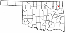
Location of Pensacola, Oklahoma
|
|
| Country | United States |
| State | Oklahoma |
| County | Mayes |
| Area | |
| • Total | 0.30 sq mi (0.78 km2) |
| • Land | 0.30 sq mi (0.78 km2) |
| • Water | 0.00 sq mi (0.00 km2) |
| Elevation | 653 ft (199 m) |
| Population
(2020)
|
|
| • Total | 101 |
| • Density | 336.67/sq mi (130.15/km2) |
| Time zone | UTC-6 (Central (CST)) |
| • Summer (DST) | UTC-5 (CDT) |
| FIPS code | 40-58050 |
| GNIS feature ID | 2413125 |
Pensacola is a small town located in Mayes County, Oklahoma, in the United States. In 2010, the town had a population of 125 people. This was a big jump from the 71 people who lived there in 2000.
Contents
History of Pensacola
The story of Pensacola began around 1840. At that time, a place called a "way station" was set up. This was a stop for travelers on the old Texas Road. It was located where the road crossed the Grand River at Cabin Creek. Here, a man named Joseph Lynch Martin, also known as "Greenbrier Joe," opened a trading post. He called this trading post Pensacola.
During the Civil War, the Union Army used Pensacola. It became a supply station for soldiers traveling between Fort Scott, Kansas and Fort Gibson, which was in Indian Territory. Two battles happened here between the Union and Confederate armies. Sadly, these battles led to Pensacola being destroyed.
Greenbrier Joe's son, Richard Martin, rebuilt Pensacola in 1896. He opened a small store and a post office at his home. This new location was about 3 miles (5 km) south of the original site.
In 1909, a settler from Kentucky named James Sims Wilson started a ranch. It was north of Pensacola and east of the Grand River. The Missouri, Oklahoma & Gulf Railroad came to this area in 1912. The railroad tracks crossed Wilson's ranch. Wilson then started planning a new town where the Pensacola post office could serve the residents. He officially registered the plan for the Pensacola townsite on April 2, 1912.
Even though the town's bank failed in 1921 and the Great Depression began, people still hoped for growth. A new dam project was announced five miles (8 km) east of town. A group called a chamber of commerce was formed, and the town officially became a city in 1938.
Pensacola never grew into a large city. It remained a small country town. Its economy relied on farming and raising cattle. The Wilson ranch surrounded the town on three sides. Also, until the Pensacola Dam and good roads were finished in 1943, it was hard for businesses to grow. The population dropped from 109 people in 1940 to just 48 in 1950.
Pensacola's Location and Size
According to the United States Census Bureau, the town of Pensacola is very small. It covers an area of about 0.1 square miles (0.26 square kilometers). All of this area is land, with no water.
Pensacola's Population Data
| Historical population | |||
|---|---|---|---|
| Census | Pop. | %± | |
| 1940 | 93 | — | |
| 1950 | 51 | −45.2% | |
| 1960 | 28 | −45.1% | |
| 1970 | 56 | 100.0% | |
| 1980 | 82 | 46.4% | |
| 1990 | 69 | −15.9% | |
| 2000 | 71 | 2.9% | |
| 2010 | 125 | 76.1% | |
| 2020 | 101 | −19.2% | |
| U.S. Decennial Census | |||
In 2010, the population of Pensacola was 125 people. Most of the people, about 78.4%, were white. About 15.2% were Native American. A small number, 0.8%, were from other races, and 5.6% were from two or more races. About 1.6% of the population was Mexican.
In the year 2000, there were 71 people living in Pensacola. These people lived in 26 households, and 19 of these were families. The town had about 497.6 people per square mile (192.1 people per square kilometer). There were 31 housing units, meaning places to live.
Education in Pensacola
Students in Pensacola attend schools that are part of the Adair Public Schools district.
See also
 In Spanish: Pensacola (Oklahoma) para niños
 | Victor J. Glover |
 | Yvonne Cagle |
 | Jeanette Epps |
 | Bernard A. Harris Jr. |

