Penton Hook Island facts for kids
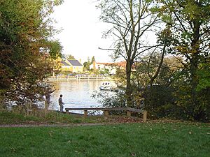
Penton Hook Island is a beautiful, mostly wooded area in the River Thames in England. It wasn't always an island! It used to be a peninsula, which is land almost completely surrounded by water but still connected to the mainland.
Since 1815, changes to the river have turned it into a series of three islands. These islands are separated by structures called weirs, which control the river's water level. Penton Hook Island also has a lock, which is like a water elevator for boats. This lock and the weirs mark the boundary between different parts of the River Thames, known as Laleham Reach and Staines Reach.
Contents
What Makes Penton Hook Island Special?
A River's Natural Loop
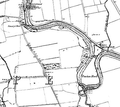
The River Thames naturally forms a big, almost complete loop here. This loop looks like a hook, which is how Penton Hook Island got its name! Today, this long, hook-shaped piece of land is a group of three islands. They are right next to Penton Hook Lock. For a very long time, even since the Middle Ages, this area has been the southern edge of Staines upon Thames.
Across the river, you'll find the Penton Hook Marina and the Penton Hook Yacht Club. There are also homes along the riverside in Thorpe, Surrey to the west. To the south and east, you'll see homes along Laleham Reach, which is part of Chertsey.
Protected Natural Area
Penton Hook Island is part of the ancient area of Staines. It's a low-lying place that can sometimes flood in winter. Because of this, people haven't built houses there. It's also protected as part of the Metropolitan Green Belt. This is a national plan to keep certain areas natural and undeveloped.
Three special gates, called sluice-controlled barrages, help manage the river's flow. These large weirs are built at the top of the river's long loop. There are also more weirs along the narrower northern part of the island.
Nature and Wildlife
Penton Hook Island is owned by the public and is not lived on by people. It's a peaceful, wooded area used for enjoying nature and protecting wildlife. On the west side, there's a special channel dug out for fish. This channel gives fish a safe place to go when the river current is strong. In 1999, a stream was built to help fish lay their eggs.
The island has many paths for you to explore. You can see different trees, squirrels, and birds nesting. You might also spot fish and various waterfowl. It's a popular spot for fishing. If you want to fish in the Thames, you can buy permits from the Environment Agency.
A Look Back in Time: History of the Island
Penton Hook Island was created when Penton Hook Lock was built in 1815. Before the lock, the Thames River would often flood the narrow neck of the "hook" of land. For a long time, people have used weirs in this part of the river. These weirs helped with fishing and made it easier for boats to travel for trade and fishing.
The Abbey River's Purpose
The monks of Chertsey Abbey were very clever. They saw how the river looped back on itself here. They used this to build what is now called the Abbey River. This was a special channel, or mill stream, that flowed from the Thames south of the island. It went past their Abbey in Chertsey before rejoining the Thames.
This channel helped drain the nearby flood meadow, called Laleham Burway. This land was used for grazing horses and cows. In 1278, there was a disagreement over who owned this land between Chertsey Abbey and Westminster Abbey. In the end, Westminster Abbey, which owned the nearby area of Laleham, gained four acres of land. In return, they gave up their claims to the lower meadow.
Controlling the River
The city of London used to manage this part of the river. During the 1700s, they tried many times to get rid of the fish-weirs. These weirs made it hard for boats to move along the river. There was at least one weir near Staines in the Middle Ages, called Savoury's Weir. It was probably located near a curve in the river close to Riverside Drive.
The city authorities built the lock at Penton Hook in 1815. They did this because the area often experienced floods. The lock helped to control the water levels and make the river safer for everyone.
 | Jewel Prestage |
 | Ella Baker |
 | Fannie Lou Hamer |


