Pepys Island facts for kids

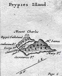
Pepys Island in detail (William Hacke, 1699, Collection of Original Voyages)
|
|

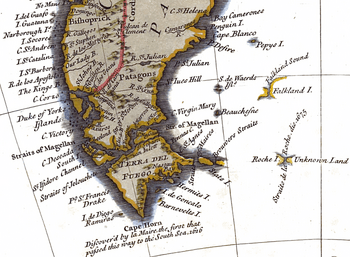
Pepys Island depicted on an 18th-century map. Roche Island is South Georgia.
(R. W. Seale, ca. 1745, fragment) |
|
| Geography | |
|---|---|
| Coordinates | 47°S 59°W / 47°S 59°W |
Pepys Island is known as a phantom island. This means it was once believed to exist but was later found not to be real. People thought it was located about 230 nautical miles north of the Falkland Islands at 47°S. Today, most experts believe that Pepys Island was actually a mistaken sighting of the Falkland Islands themselves.
Contents
What is a Phantom Island?
A phantom island is a piece of land that appeared on maps for a time but was later proven not to exist. Sometimes, these islands were reported by explorers who made mistakes in their navigation. Other times, they might have seen mirages or misidentified known islands. The story of Pepys Island is a famous example of such a mystery.
The First Sighting: William Cowley's Journey
In December 1683, a British privateer named William Ambrose Cowley was on an amazing journey. He was sailing around the world on his ship, the Bachelor's Delight. A privateer was like an explorer who also had permission from their government to capture enemy ships.
During his voyage, Cowley reported seeing an unknown island in the South Atlantic Ocean. He recorded its location as 47°S. He decided to name this new land "Pepys Island" after Samuel Pepys. Pepys was a very important official in the British government at the time.
Cowley's travel companion, William Dampier, had a different idea. He thought the island Cowley saw might actually be the "Sebaldinas Islands." This was another name used for the Falkland Islands back then.
Cowley's Description of Pepys Island
Cowley wrote in his ship's logbook about what he saw. He described Pepys Island as an "unknown and uninhabited island." He noted it had "good fresh water" and materials for starting fires. He also mentioned an "excellent harbour" where many ships could safely anchor. The island seemed full of life, with "enormous numbers of birds" and "abundant fishing" in the waters around it.
A more detailed account from January 1683 added to his description. It said the island looked "pleasant" and was "totally wooded." Near the island, there was a rock covered with many birds. Cowley's crew hunted these birds for food. They found them "quite tasty" but noted they had a "fishy flavour."
Cowley also described a large harbor on the southwest coast. He thought it could hold many ships. However, he noted that the entrance was narrow. He also mentioned that his main goal was not to explore new lands. He was focused on his journey around the world. He later saw another island, which made him think again about the "Sebaldes" (Falkland Islands).
Searching for Pepys Island: Explorers' Attempts
After Cowley's report, many famous explorers tried to find Pepys Island. Throughout the 1700s, expeditions sailed to the South Atlantic, hoping to locate this mysterious land. Some of these well-known explorers included Lord Anson, Commodore Byron, and Captain Cook. Louis de Bougainville and George Vancouver also searched for it.
Despite their efforts, none of these expeditions ever found Pepys Island. They often reported seeing "thick sargasso." Sargasso is a type of seaweed that floats in large mats on the ocean surface. They also saw "large flocks of birds" flying overhead. These signs usually mean land is nearby. However, the explorers could not find the island itself.
For example, Jean-François de Galaup, comte de Lapérouse noted the seaweed and identified the birds as albatross and petrels. These birds only come to land to lay their eggs. This suggested land was indeed close, but Pepys Island remained hidden.
The Mystery Continues: Was it the Falklands?
In 1839, a historian named Pedro de Angelis believed Pepys Island was real. He argued that an experienced sailor like Cowley would not have made such a big mistake in location. De Angelis thought Pepys Island was a separate, large island, perhaps known by other names like "Puig" or "the Great Island." He even claimed to have seen sketches that supported this idea.
However, modern experts, like Professor Pesatti, disagree. Professor Pesatti believes that Cowley's description of Pepys Island matches the Falkland Islands very closely. He suggests that if Cowley's original map were available, it would show the layout of the Falklands.
Today, most historians and geographers agree with Professor Pesatti. They conclude that Pepys Island was not a separate landmass. Instead, it was likely a misidentified sighting of the Falkland Islands. This makes Pepys Island a fascinating part of the history of exploration and cartography (map-making).
See also
- Aurora Islands
- Groclant
 | Kyle Baker |
 | Joseph Yoakum |
 | Laura Wheeler Waring |
 | Henry Ossawa Tanner |

