Pier Fire facts for kids
Quick facts for kids Pier Fire |
|
|---|---|

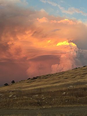
Pier Fire on the evening of August 29, 2017
|
|
| Location | Sequoia National Forest, California, United States Springville, California, United States |
| Coordinates | 36°09′32″N 118°41′46″W / 36.159°N 118.696°W |
| Statistics | |
| Date(s) | August 29, 2017 – November 29, 2017 |
| Burned area | 36,556 acres (148 km2) |
| Cause | Human caused |
| Non-fatal injuries | 5 |
| Map | |
The Pier Fire was a large wildfire that burned near Springville in California. It also affected the beautiful Sequoia National Forest in the United States. The fire started on August 29, 2017. Experts believe a human caused the fire, but the exact reason is still being investigated.
The Pier Fire was finally put out on November 29, 2017. It had burned a huge area of 36,556 acres (148 km2) (about 148 square kilometers). This fire was a big threat to very old and tall sequoia trees. It also put the Tule River Indian Reservation and many small towns nearby in danger.
Contents
How the Fire Started and Grew
First Days of the Fire: August 29-30
The Pier Fire was first noticed very early on August 29 at 2:30 AM. It was seen in the Tule River Canyon, just north of Springville, California. The fire began in a national forest. Because of this, federal and state officials worked together to investigate its cause.
By the end of that first day, the fire had already burned 1,650 acres (7 km2). This area was both north and south of Highway 190. It was located in the Giant Sequoia National Monument within the Sequoia National Forest. This rapid spread led to many people being told to leave their homes for safety. Parts of Highway 190 were also closed.
By August 30, the fire had grown even bigger, reaching 4,655 acres (19 km2). It started to threaten the Tule River Reservation. Two special groups of sequoia trees, the Mountain Home Grove and Black Mountain Grove, were also in danger. Firefighters found it hard to reach the fire. This was because of the steep hills, thick dry plants (called heavy fuels), and few roads. Highway 190 stayed closed in some areas. Balch Park and Mountain Home Demonstration State Forest were also closed.
Fire Spreads and More Help Arrives: September 1-3
On September 1, the fire continued to grow quickly, covering 10,311 acres (42 km2). The flames even jumped over Highway 190 and the middle part of the Tule River. This brought the fire closer to campgrounds. More firefighters were needed because the fire was so large and difficult to control. Teams from CAL FIRE and Tulare County joined in, bringing the total number of people fighting the fire to 1,243. More residents, especially those on Balch Park and Bear Creek Roads, had to leave their homes.
On September 2, California Assemblyman Devon Mathis visited the fire command center. That day, the fire grew by about 4,000 acres. This growth was mainly due to the dry plants, not strong winds. On September 3, a water channel (called a flume) belonging to Southern California Edison was destroyed by the fire. Replacing it was estimated to cost between $3 million and $5 million. Southern California Edison also lost a valve house, six power poles, and a transmission structure.
Getting the Fire Under Control: September 11-24
By September 11, firefighters had the fire 60% contained. It had burned 27,586 acres (112 km2) by this time. The evacuation orders for Cow Mountain, Springville, and Upper Rio Vista were changed. People could now return to their homes, but they were advised to be ready to leave again if needed. Fire crews successfully controlled the fires near the Tule River Reservation. On the evening of September 14, mandatory evacuation orders for many communities were also changed to voluntary. These communities included Alpine Village, Camp Nelson, Cedar Slope, Doyle Springs, Mountain Aire, Rogers Camp, Pierpoint Springs, Sequoia Crest, and Wishon.
In mid-September 2017, firefighters were finishing up putting out smaller fires near Pine Flat Road. They then planned to start controlled burns and create fire breaks in Soda Springs. This work was done on the Tule River Reservation to protect buildings there.
On September 24, the Pier Fire was 100% contained around its edges. The total area burned was 36,556 acres (148 km2). However, some hot spots continued to burn inside the fire area for a few more months. These last hot spots were finally put out by rain from a winter storm on November 29.
Evacuations and Closures
During the Pier Fire, a section of Highway 190 was closed to all traffic. This closure was from the Tule Power House to Pierpoint Springs. Lands, trails, and roads in the Sequoia National Forest around the fire area also remained closed for safety.


