Pinnebog River facts for kids
Quick facts for kids Pinnebog River |
|
|---|---|

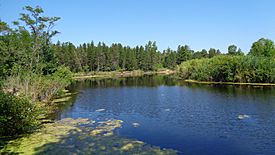
The river within Port Crescent State Park
|
|
|
Location within the state of Michigan
|
|
| Physical characteristics | |
| Main source | Colfax Township, Michigan 43°50′22″N 83°05′58″W / 43.83944°N 83.09944°W |
| River mouth | Lake Huron Hume Township, Michigan 577 ft (176 m) 44°00′21″N 83°03′39″W / 44.00583°N 83.06083°W |
| Length | 39.4 mi (63.4 km) |
The Pinnebog River is a river in the Michigan area known as "The Thumb." It is about 39.4 miles (63.4 km) long. This river flows into Lake Huron on the western side of this "thumb" shaped region.
Contents
River's Journey
The Pinnebog River is entirely located within Huron County. It gets its water from many farm ditches and drains. The river starts where two smaller streams, the Colona and Colfax drains, meet. This spot is near Colfax Township, south of the M-53 highway.
Flowing North
From its start, the river flows southwest for about 2 miles (3.2 km). It goes around a small area called Popple. Here, it picks up more water from the Cameron and McLean drains.
Then, the river turns and flows northwest for about 5 miles (8.0 km). It passes by the eastern side of the village of Elkton. After Elkton, the Pinnebog River mostly flows northward.
Reaching Lake Huron
The river finally reaches Lake Huron in Port Crescent State Park. This is about 4 miles (6.4 km) southwest of Port Austin. Before it enters Lake Huron, the river turns to flow east-northeast for about 3 miles (4.8 km). Just before its mouth, it is joined by the Taft and Schram drains.
Other streams that feed the Pinnebog River include:
- Elkton Drain
- Nettle Run
- Hill Drain
- Southworth Drain
- McMullen Drain
- Oliver Drain
- Bad Axe Creek
- Musselman Drain (which drains Rush Lake)
River's Surroundings
The area that the Pinnebog River and its smaller streams drain is called its watershed. This watershed covers parts of many townships in Huron County.
Townships in the Watershed
The Pinnebog River's watershed includes all or parts of these townships:
Nearby Community
The small community of Pinnebog is located on the Taft Drain. The Pinnebog River itself flows about 1 mile (1.6 km) to the west of this community. Pinnebog Road, also known as County Road L, runs for about 13 miles (21 km) from north of Pinnebog south to Van Dyke Road.


