Pioneer, Tasmania facts for kids
Quick facts for kids PioneerTasmania |
|||||||||||||||
|---|---|---|---|---|---|---|---|---|---|---|---|---|---|---|---|

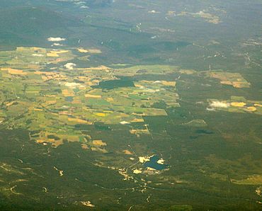
Pioneer at the bottom of the photo, near the boomerang-shaped Pioneer Lake
|
|||||||||||||||
| Population | 89 (2016 census) | ||||||||||||||
| Postcode(s) | 7264 | ||||||||||||||
| Location | 50 km (31 mi) NE of Scottsdale | ||||||||||||||
| LGA(s) | Dorset Council | ||||||||||||||
| Region | North-east | ||||||||||||||
| State electorate(s) | Bass | ||||||||||||||
| Federal Division(s) | Bass | ||||||||||||||
|
|||||||||||||||
Pioneer is a small place in the countryside located in the Dorset area of Tasmania. It is part of the North-east region of Tasmania. Pioneer is about 50 kilometers (about 31 miles) north-east of the town of Scottsdale. In 2016, a count of the population showed that only 89 people lived in Pioneer.
History of Pioneer
Pioneer officially became a recognized place in 1955. Before that, it was called Bradshaw Creek. This name came from William Bradshaw, who started the Pioneer Tin Mine in the area. Even though the name officially changed in 1955, people were already calling it Pioneer as early as 1902. The post office, which opened in 1883 as Bradshaw's Creek Post Office, also changed its name to Pioneer in 1955.
Geography of Pioneer
Pioneer is a place with interesting natural features. The Ringarooma River flows through the area, moving from the west side towards the north. Another river, the Wynford River, enters Pioneer from the south. It then flows north until it meets the Ringarooma River right in the middle of the locality.
Roads and How to Get Around
Pioneer has a few main roads that help people travel through and around the area.
Main Roads in Pioneer
- Route B82, also known as Gladstone Road or Main Road, goes through Pioneer. It enters from the west and continues towards the north.
- Route C839, called Racecourse Road, begins where it meets B82. It then travels north-west before leaving the area.
- Route C841, known as Tebrakunna Road, also starts at an intersection with B82. This road heads east until it exits Pioneer.
 | Selma Burke |
 | Pauline Powell Burns |
 | Frederick J. Brown |
 | Robert Blackburn |


