
Pitman, New Jersey facts for kids
Quick facts for kids
Pitman, New Jersey
|
||
|---|---|---|
|
Borough
|
||

Broadway Theater in Pitman, September 2010
|
||
|
||
| Motto(s):
"The Small Town With A Big Heart"
"Everybody Likes Pitman" |
||

Map of Pitman highlighted within Gloucester County. Inset: Location of Gloucester County in New Jersey.
|
||

Census Bureau map of Pitman, New Jersey
|
||

Pitman, New Jersey
Location in Gloucester County, New Jersey

Pitman, New Jersey
Location in New Jersey

Pitman, New Jersey
Location in the United States
|
||
| Country | ||
| State | ||
| County | ||
| Incorporated | May 24, 1905 | |
| Government | ||
| • Type | Borough | |
| • Body | Borough Council | |
| Area | ||
| • Total | 2.26 sq mi (5.85 km2) | |
| • Land | 2.22 sq mi (5.75 km2) | |
| • Water | 0.04 sq mi (0.11 km2) 1.81% | |
| Area rank | 390th of 565 in state 17th of 24 in county |
|
| Elevation | 125 ft (38 m) | |
| Population
(2020)
|
||
| • Total | 8,780 | |
| • Estimate
(2023)
|
8,880 | |
| • Rank | 271st of 565 in state 13th of 24 in county |
|
| • Density | 3,958.5/sq mi (1,528.4/km2) | |
| • Density rank | 159th of 565 in state 3rd of 24 in county |
|
| Time zone | UTC−05:00 (Eastern (EST)) | |
| • Summer (DST) | UTC−04:00 (Eastern (EDT)) | |
| ZIP Code |
08071
|
|
| Area code(s) | 856 | |
| FIPS code | 3401559070 | |
| GNIS feature ID | 0885354 | |

Pitman is a small town, also called a borough, located in Gloucester County, in the state of New Jersey in the United States. In 2020, about 8,780 people lived there. The town is named after Rev. Charles Pitman, who was a Methodist minister.
Contents
History of Pitman
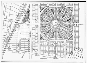

Pitman started in 1871 as a place for Methodist summer camp meetings. Land was chosen in nearby Glassboro and Mantua Township for this purpose. In 1872, the New Jersey Conference Camp Meeting Association was formed. They planned the campground with a central meeting area and twelve roads spreading out like spokes on a wheel.
This area became known as the Pitman Grove. At first, people stayed in tents along the roads. Over time, small cottages replaced the tents. These cottages became the first homes in what is now Pitman. By the 1880s, there were about 400 cottages, and people started living there all year. This led to the first public school opening in 1884.
More businesses appeared north of the Grove by 1887. In 1892, Alcyon Park was created. The leaders of the Grove wanted to keep it as a religious retreat. However, in 1904, the people living in the Grove voted to become their own town. On May 24, 1905, the Governor of New Jersey, Edward C. Stokes, signed a law making Pitman an official borough.
The Pitman Grove was recognized as an important historical site in 1977. It was added to the National Register of Historic Places.
For many years, Pitman was a "dry town." This meant that it was not allowed to sell alcoholic drinks. In 2014, this rule changed. In 2015, the town council allowed businesses to get licenses to sell drinks. By 2016, some local breweries opened in Pitman's main business area. In November 2016, most voters agreed to allow more liquor licenses.
Geography and Location
Pitman covers a total area of about 2.26 square miles (5.85 square kilometers). Most of this is land, with a small amount of water. The borough shares its borders with other towns in Gloucester County. These include Glassboro, Mantua Township, and Washington Township.
Population Changes

The number of people living in Pitman has changed over the years.
- 1910: 1,950 people
- 1920: 3,385 people
- 1930: 5,411 people
- 1940: 5,507 people
- 1950: 6,960 people
- 1960: 8,644 people
- 1970: 10,257 people
- 1980: 9,744 people
- 1990: 9,365 people
- 2000: 9,331 people
- 2010: 9,011 people
- 2020: 8,780 people
In 2023, the population was estimated to be around 8,880 people.
2010 Census Information
In 2010, there were 9,011 people living in Pitman. There were 3,489 households, which are groups of people living together. About 29% of households had children under 18. Most people in Pitman were White (96.08%). A smaller number were Black or African American (1.14%), Asian (0.62%), or from other backgrounds. About 2.46% of the population was Hispanic or Latino.
The average age in Pitman in 2010 was 41.2 years old. About 22.4% of the population was under 18.
Local Government

Pitman is governed by a borough system, which is common in New Jersey. The town is run by a mayor and a borough council. The mayor is elected for a four-year term. The council has six members, who are elected for three-year terms. Two council seats are up for election each year.
In Pitman's government, the council makes most of the laws. The mayor leads meetings and only votes if there is a tie. The mayor can also reject new laws, but the council can overrule this decision with a two-thirds vote. The mayor also assigns council members to different committees.
As of 2025, the mayor of Pitman is Michael L. Razze, Jr. His term ends on December 31, 2027. The current members of the Pitman Borough Council are:
- Vanessa James (term ends 2025)
- John Fitzpatrick (term ends 2025)
- Debra Guarni (term ends 2027)
- Adam Mazzola (term ends 2026)
- Sarah Musto (term ends 2027)
- Robert Uyehara (term ends 2026)
Education in Pitman
The Pitman School District serves students from pre-kindergarten through twelfth grade. As of the 2022–23 school year, the district had 1,147 students and 122.4 teachers. This means there were about 9.4 students for every teacher.
The schools in the district are:
- Memorial Elementary School: for students in PreK–1st grade.
- Pitman Elementary School: for students in 2nd–6th grade.
- Pitman Junior / Senior High School: for students in 7th–12th grade.
There is also a private school called Guardian Angels Regional School. It is a K–8 school that is part of the Roman Catholic Diocese of Camden. One of the churches that sends students to this school is Our Lady Queen of Peace Church in Pitman.
Transportation Options
_at_Pitman_Avenue_along_the_border_of_Pitman_and_Glassboro_in_Gloucester_County,_New_Jersey.jpg)
As of 2015, Pitman had about 37.20 miles of roads. Most of these roads (29.77 miles) are maintained by the town itself. The rest (7.43 miles) are maintained by Gloucester County.
Major Roads
Route 47 is the main highway that runs along Pitman's eastern border. Other important county roads that go through Pitman include County Route 553 and County Route 553 Alternate. Route 55 is a major highway that passes just west of Pitman.
Public Transit
NJ Transit provides bus service for people traveling between Pitman and Philadelphia. The bus routes that serve Pitman are the 313, 408, and 412.
Pitman is also planned to be a stop on the Glassboro–Camden Line. This is a new light rail system that will be about 18 miles long. It was expected to be finished by 2025.
Notable People from Pitman
Many interesting people have connections to Pitman. Here are a few:
- Madeline Brewer (born 1992), an actress known for her roles in "Orange is the New Black" and "The Handmaid's Tale".
- Joe Crispin (born 1979), a basketball player who scored the most points in Gloucester County high school history. He played in the NBA for the Lakers and Suns.
- Jon Crispin (born 1981), Joe's brother, who was also a top high school basketball scorer. He played college basketball for Penn State and UCLA.
- Preston Foster (1900–1970), an actor.
- C. Austin Miles (1868–1946), a writer of many hymns and gospel songs, including the famous 1912 hymn "In the Garden".
- Patti Smith (born 1946), a famous singer-songwriter, poet, and artist.
- Don Wildman (born 1961), an actor and television host.
Images for kids
-
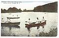
Alcyon Lake
See also
 In Spanish: Pitman (Nueva Jersey) para niños
