Plaza de Mayo facts for kids
Quick facts for kids Plaza de Mayo |
|
|---|---|
| City square | |
 |
|
| Features: | May Pyramid Surrounded by the Cabildo, Casa Rosada, the Metropolitan Cathedral, the Buenos Aires City Hall, the Bank of the Argentine Nation headquarters and Palacio de Hacienda. |
| Opening date: | 1580 (Plaza Mayor) 1884 (unification) |
| Location: | Monserrat Buenos Aires, Argentina |
|
Location of Plaza de Mayo in Buenos Aires |
|
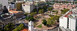
The Plaza de Mayo (which means May Square in English) is a very important city square in Buenos Aires, Argentina. It's known as the main founding place of the city. The square was created in 1884. This happened after a building called the Recova was taken down. This demolition joined two older squares: the Plaza Mayor and the Plaza de Armas. These were then known as Plaza de la Victoria and Plaza 25 de Mayo.
Located in the city center of Buenos Aires, Plaza de Mayo has been the stage for many important events in Argentine history. It has also seen the biggest public gatherings in the country. In 1811, on the first anniversary of the May Revolution, the Pirámide de Mayo (May Pyramid) was opened in the square's center. This pyramid became Buenos Aires' first national monument.
The square is in the financial area called microcentro. This is part of the neighborhood of Monserrat. It is bordered by Bolívar, Hipólito Yrigoyen, Balcarce, and Avenida Rivadavia streets. Three important avenues start from its west side: Avenida Presidente Julio Argentino Roca, Avenida Roque Sáenz Peña, and Avenida de Mayo. Many important buildings and landmarks are around the square. These include the Cabildo, the Casa Rosada (where the President of Argentina works), the Metropolitan Cathedral, the Buenos Aires City Hall, and the main office of the Bank of the Argentine Nation. Below the square, you can find subway stations. These are Plaza de Mayo (for Line A), Catedral (for Line D), and Bolívar (for Line E).
Contents
History of Plaza de Mayo
The Plaza de Mayo we see today was formed in 1884. This happened when a large building, which separated two older squares, was removed. But the story of the plaza goes back much further. It started in 1580 when Juan de Garay founded Buenos Aires.
In 1608, Jesuit priests got the rights to a large piece of land. This land was where Garay had planned for a central plaza. In 1661, the local governor bought the eastern half of this land. He wanted to add it to the city's new fort. This part soon became known as the Plaza de Armas.
After many years of heavy use and not much care, the local government tried to organize the plaza. They built a long structure with columns, called a colonnade, across it. This was finished in 1804. This Romanesque building became the plaza's market. The area to the west of this colonnade became the Plaza de la Victoria.
These two plazas stayed separate until 1883. There were only small changes to the area during this time. A major change was the addition of the May Pyramid in 1811. This monument was built to remember the new independence of the "Provinces of the Rio de la Plata". However, in 1883, Mayor Torcuato de Alvear decided to modernize the space. This led to the colonnade being torn down. This action created the single, modern Plaza de Mayo we know today.
Important Buildings Around the Plaza
The Plaza de Mayo is surrounded by many important buildings. These buildings show different parts of Argentina's history and government.
- Casa Rosada: This is the official office and home of the President of Argentina. Its name means "Pink House" because of its color.
- Buenos Aires Cabildo: This historic building was the city council during the time of Spanish rule. It's a key place in Argentina's fight for independence.
- Metropolitan Cathedral of Buenos Aires: This is the main Catholic church in Buenos Aires. It's known for its grand architecture and historical importance.
- Buenos Aires City Hall: This building houses the city government of Buenos Aires.
- Bank of the Argentine Nation: This is the headquarters of one of Argentina's most important banks.
- May Pyramid: Located in the center of the square, this monument celebrates the May Revolution. It was the first national monument in Buenos Aires.
The financial district of Buenos Aires, often called microcentro, is also right next to the Plaza.
Plaza de Mayo Today
Today, Plaza de Mayo is a must-see for anyone visiting Buenos Aires. It is a very popular tourist attraction.
The square continues to be a place where people gather for important events. It is also a beautiful spot to visit. You can see the May Pyramid in the center. You can also see the Equestrian monument to General Manuel Belgrano. This statue honors a hero of Argentina's independence.
Images for kids
-
Celebration of the May Revolution, 1910.
See also
 In Spanish: Plaza de Mayo para niños
 | Leon Lynch |
 | Milton P. Webster |
 | Ferdinand Smith |


