Plymouth, Mississippi facts for kids
Quick facts for kids
Plymouth, Mississippi
|
|
|---|---|

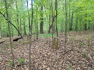
Cemetery at Plymouth
|
|
| Country | United States |
| State | Mississippi |
| County | Lowndes |
| Elevation | 210 ft (60 m) |
| Time zone | UTC-6 (Central (CST)) |
| • Summer (DST) | UTC-5 (CDT) |
| GNIS feature ID | 710094 |
|
Plymouth, Mississippi
|
|
| Lua error in Module:Location_map at line 420: attempt to index field 'wikibase' (a nil value). | |
| Nearest city | Columbus, Mississippi |
|---|---|
| Area | 210 acres (85 ha) |
| NRHP reference No. | 80002288 |
| Added to NRHP | April 22, 1980 |
Plymouth was an early settlement in Mississippi. It was located in what is now Lowndes County. You could find Plymouth on the west bank of the Tombigbee River. It was right where Tibbee Creek flows into the river. Today, Plymouth is known as a ghost town.
Contents
History of Plymouth
Local stories say that the famous explorer Hernando de Soto once camped near Plymouth. Later, Jean-Baptiste Le Moyne de Bienville built a fort here. This was during his fight against the Chickasaw people.
How Plymouth Started
The community of Plymouth began around 1819. It grew around the strong house of John Pitchlynn. He was an important interpreter for the U.S. government with the Choctaw people. Pitchlynn's home was surrounded by a stockade. A stockade is a fence made of strong wooden posts. This was done during the Creek War. The house was called Fort Smith, named after Captain George Smith. Captain Smith worked for Colonel John McKee. They used Fort Smith to attack the Red Sticks. The Red Sticks were a group of Creek warriors. They lived along the Black Warrior River.
Life in Early Plymouth
Plymouth became a busy place. Many stores and cotton warehouses were built there. Cotton was a very important crop back then. However, Plymouth was built on low ground. This meant it often flooded when the river rose.
Across the river was a town called Columbus. Both towns had high bluffs, which are steep cliffs. But Plymouth's river landing was hard to reach from its high bluffs. This made it less convenient than Columbus.
Why Plymouth Disappeared
The community officially became a town in 1836. At its busiest, about 200 people lived there. After becoming a town, streets were planned out in squares. But by the 1840s, people started leaving. Most residents moved across the river to Columbus. Columbus had a better location.
A post office served Plymouth from 1833 to 1855. There was also a school called the Plymouth Academy. It operated from 1837 to 1866.
Today, the old site of Plymouth is west of the John C. Stennis Lock and Dam. This dam is part of the Tennessee-Tombigbee Waterway. An area of about 210 acres was added to the National Register of Historic Places in 1980. This area includes the old village site and a cemetery.
Plymouth Bluff Today
Plymouth Bluff is just downstream from where the village used to be. Today, it is home to the Plymouth Bluff Environmental Center. The Mississippi University for Women operates this center. It is on land owned by the Army Corps of Engineers.
The center is a local hub for studying nature and the environment. It is also used as a place for meetings and retreats.
Fossil Discoveries at Plymouth Bluff
Many interesting fossils have been found in the Bluffs. One exciting discovery was a hadrosaur. Hadrosaurs were a type of duck-billed dinosaur.


