
Ponte da Ajuda facts for kids
Quick facts for kids Bridge of AjudaPonte da Ajuda/Puente de Ayuda |
|
|---|---|

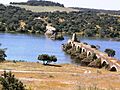
A view of the ruined bridge over Guadiana River showing banks in Portugal and Spain
|
|
| Coordinates | 38°46′35″N 7°10′14″W / 38.7764°N 7.1706°W |
| Carries | Abandoned |
| Crosses | Guadiana River |
| Locale | Ajuda/Ayuda |
| Official name | Ponte de Nossa Senhora da Ajuda Puente de Nuestra Señora de Ayuda |
| Named for | Nossa Senhora da Ajuda/Nuestra Señora de Ayuda |
| Owner | Portugal/Spain |
| Heritage status | Imóvel de Interesse Público/Bien de Interés Cultural |
| Characteristics | |
| Material | Stone |
| Total length | 453 m (1,486.2 ft) |
| Width | 5 m (16.4 ft) |
| Height | 161 m (528.2 ft) |
| Number of spans | 1 |
| Piers in water | 13 |
| History | |
| Constructed by | Arrudas |
| Construction begin | 1510 |
| Opened | 1521 |
| Rebuilt | 1640 |
| Collapsed | 1657 |
| Closed | 1709 |
The Bridge of Ajuda (also known as Portuguese: Ponte de Nossa Senhora da Ajuda in Portuguese and Spanish: Puente de Nuestra Señora de Ayuda in Spanish) is an old, ruined bridge. It crosses the Guadiana River and connects the towns of Elvas in Portugal and Olivenza in Spain. This historic stone bridge has a long and interesting past, showing how important it once was for travel and trade between the two countries.
Contents
History of the Bridge of Ajuda

The Bridge of Ajuda was built a long time ago, between 1520 and 1521. This happened during the rule of King D. Manuel I of Portugal. It was built from the Portuguese side of the Guadiana River, near a place called Senhora da Ajuda. The bridge was part of a road that connected Elvas and Olivença. Some people believe the "Arruda brothers" were the builders.
Early Damage and Repairs
In 1597, just a few decades after it was built, many parts of the bridge were damaged. This happened because of big floods in the river.
Later, between 1640 and 1642, a governor named Matias de Albuquerque was in charge of the Alentejo region. He started making the town of Olivença stronger by building new walls. During this time, the bridge was in bad shape. It's thought that it was rebuilt or repaired around this period.
However, the bridge faced more trouble. In 1657, Spanish forces partly destroyed it. But it was rebuilt again in the same century.
Wars and Final Destruction
In 1705, new defenses were added to the bridge. These were designed by a person named Manuel da Maia. But the bridge's problems continued. In 1709, during a big conflict called the War of the Spanish Succession, the bridge was partly destroyed by cannons.
Years later, in 1801, the Spanish army, led by D. Manuel Godoy, took control of the town of Olivença. This event changed the area's history.
Modern Efforts to Rebuild
In 1903, King D. Carlos of Portugal suggested that the bridge should be rebuilt. This shows that people still remembered its importance.
The Bridge of Ajuda is now recognized as a special historical site. On January 24, 1967, the Portuguese government declared it a Imóvel de Interesse Público. This means it's a "Property of Public Interest." Then, on March 13, 2009, the Spanish government also recognized it. They called it a Bien de Interés Cultural, which means "Possession of Cultural Interest." These titles help protect the bridge as an important part of history.
What the Bridge Looks Like Now

The Bridge of Ajuda is in a quiet, natural area. It's surrounded by wild plants and is about 100 metres (330 ft) from a small church called the Chapel of Nossa Senhora da Ajuda. The bridge is on an old, unused road that runs for about 12 kilometres (7.5 mi) between Elvas and Olivenza.
Even though it's in ruins, we know the bridge was very long. It measured about 453 metres (1,486 ft) in length and 5 metres (16 ft) in width. Its highest point was about 161 metres (528 ft) above the river.
Today, you can still see parts of the bridge. There are eight arches left on the right side of the river. On the left side, five arches remain. These arches are rounded and are supported by strong stone structures called talhamares. These talhamares are like pointed supports that help the bridge stand against the river's current.

Along the main part of the bridge, there was once an old tower. This tower was built over large rocks that you can still see near the riverbank. The bridge's design shows how skilled builders were in the past.
Images for kids
-
A view of the ruined bridge over Guadiana River showing banks in Portugal and Spain
See also
 In Spanish: Puente de Ajuda para niños
