Port Eads, Louisiana facts for kids
Quick facts for kids
Port Eads
|
|
|---|---|

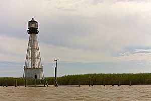
Lighthouse at Port Eads
|
|
| Country | United States |
| State | Louisiana |
| Parish | Plaquemines |
| Elevation | 0 ft (0 m) |
| Time zone | UTC-6 (CST) |
| • Summer (DST) | UTC-5 (CDT) |
| Area code(s) | 504 |
Port Eads is a small community located at the very end of the Mississippi River. It sits in Plaquemines Parish, Louisiana, in the United States. This special place is also known as South Pass. In 1982, it was named a National Historic Civil Engineering Landmark. This means it's recognized for its important engineering history.
Contents
History of Port Eads
How James Eads Helped the River
The Mississippi River is very long. The part near the Port of New Orleans often got clogged with mud. This made it hard for big ships to pass through. Ships would get stuck, or parts of the river became too shallow.
In 1876, a clever engineer named James Buchanan Eads found a solution. He built a system of wooden walls called jetties. These jetties made the river's main path narrower. This caused the water to flow faster. The faster water then dug the river channel deeper.
This amazing work allowed large ships to use the river all year long. After the jetties were finished, trade in New Orleans doubled. Because of his great work, the port at South Pass was named after James Eads. His jetty design was also recognized as a National Historic Civil Engineering Landmark in 1982.
Rebuilding After Hurricane Katrina
In 2005, Hurricane Katrina caused huge damage to Port Eads. Almost everything was destroyed. Only the lighthouse and a few fishing camps were left standing.
The Federal Emergency Management Agency (FEMA) first offered $400,000 to rebuild the Port Eads Marina. However, the local leader, Parish President Billy Nungesser, felt this was not enough. He went to Washington, D.C., to ask for more money. In 2009, FEMA agreed to provide up to $12 million for the project. This helped Port Eads begin to rebuild.
Geography and Fishing
Location of Port Eads
At a place called the Head of Passes, the Mississippi River splits into three main branches. Port Eads is found at the southern tip of the middle branch. A lighthouse stands there to guide large ships coming from the ocean. You can only reach Port Eads by boat or helicopter.
A Hub for Fishermen
Port Eads is very popular with people who fish in the deep ocean. Many fishermen start their trips in Venice, Louisiana, which is about 20 miles north. Port Eads offers many services for these fishermen. They can dock their boats and refuel there.
The port also has small rooms for rent where fishermen can rest. There is a weigh station for their catches and a small restaurant. Port Eads is special because it is the closest port to the continental shelf in the entire Gulf of Mexico. The continental shelf is a part of the ocean floor that drops off sharply. This shelf is only five miles from the port, making it a perfect spot for offshore fishing.
Fishing Tournaments
Every June, Port Eads hosts the New Orleans Invitational Billfish Tournament. This is a big fishing competition. Two very large Atlantic blue marlin have been caught by boats using Port Eads. These fish each weighed over one thousand pounds. They are two of only three such "granders" ever recorded in the Gulf of Mexico.
See also
 In Spanish: Port Eads para niños
 | Precious Adams |
 | Lauren Anderson |
 | Janet Collins |


