Head of Passes facts for kids
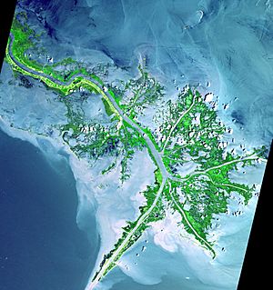
The Head of Passes is a special spot where the mighty Mississippi River splits into three main branches right before it flows into the Gulf of Mexico. These branches are called Southwest Pass (to the west), Pass A Loutre (to the east), and South Pass (in the middle). Together, they form what looks like a "Bird's Foot Delta" from above. This delta is the newest part of the ever-growing land created by the Mississippi River.
People consider the Head of Passes to be the official mouth of the Mississippi River.
The United States Army Corps of Engineers helps keep a deep shipping channel open. This channel is 45 feet (about 13.7 meters) deep. It runs from the mouth of Southwest Pass, which is about 20 miles (32 km) downstream from the Head of Passes, all the way up to Baton Rouge, Louisiana. Baton Rouge is the farthest inland port in the U.S. that can handle large ships.
The Mouth of Passes refers to where all these individual branches (Southwest, South, North, and Pass a Loutre) finally empty into the Gulf. Most of the Mississippi River's water flows out through these mouths. However, some water also flows out through the Atchafalaya River mouth, and a small amount seeps out along the 200 miles (300 km) of the Delta's shoreline.
The Mississippi River During the Civil War
During the American Civil War, the Head of Passes was an important location for several naval battles. The Union Army had a plan called the Anaconda Plan. This plan aimed to block off the Confederacy and gain control of the Mississippi River.
Battles at the Head of Passes
The Union started their blockade at the Head of Passes in 1861. This led to a fight known as the Battle of the Head of Passes. During this battle, the Union forces were temporarily pushed out of the area. Some of the ships involved in these conflicts included the CSS Manassas, the USS Vincennes, and the USS Richmond.
Port Eads, Louisiana is a small place located at the very end of the South Pass.
Measuring River Distances
The Head of Passes is used as a starting point for measuring distances along the Lower Mississippi River. These distances are called "mileages." For example, Algiers Point is located 94.6 miles "AHP" (Above Head of Passes). Cairo, Illinois, which is much farther north, is at mile 953.8 AHP. Distances downstream from the Head of Passes are labeled "BHP" (Below Head of Passes).
 | Misty Copeland |
 | Raven Wilkinson |
 | Debra Austin |
 | Aesha Ash |


