
Porters Ski Area facts for kids
Quick facts for kids Porters |
|
|---|---|
 |
|
 |
|
| Location | Selwyn Canterbury |
| Nearest city | Springfield |
| Coordinates | 43°16′26″S 171°38′34″E / 43.273792°S 171.642778°E |
| Vertical | 620 m |
| Top elevation | 1995 m (6545 ft) 'Allison Peak' 43°15′45″S 171°37′53″E / 43.26259°S 171.63129°E |
| Base elevation | 1302 m (4272 ft) |
| Skiable area | 700 Ha |
| Runs | 29 |
| Longest run | 2km - McNulty's Basin |
| Lift system | 6 lifts: 3 T-bar lifts, 1 Platter lift, 1 Magic carpet, 1 Chairlift |
| Terrain parks | 1 |
| Snowmaking | Yes |
| Night skiing | No |
| Website | https://portersalpineresort.com/ |

Porters is a popular ski resort in the South Island of New Zealand. It is located about an hour's drive (98 km) west of Christchurch. Porters started as a club skifield, which means it was run by a club for its members.
Today, Porters has a variety of ski lifts. These include one magic carpet for beginners, one platter tow, one chairlift, and three T-bars. The ski slopes are designed for different skill levels. About 15% are for beginners, 35% for intermediate skiers, and 50% are for advanced skiers. The resort uses modern machines to groom the snow. They also have snowmaking equipment along the main ski runs near the chairlift.
Porters has a lodge with 42 beds, which is run by a club. It is located on the road leading up the mountain. The resort says it's a very welcoming place for everyone.
In the late 1980s, there wasn't much snow. So, in 1991, Porters became the first ski field in New Zealand to install snowmaking machines. This helped them make their own snow when needed.
The ski field's name changed from Porter Heights to Porters in 2007. This happened when new owners took over. By 2020, it was renamed again to Porters Alpine Resort. These changes have brought many improvements. For example, they got a new snow groomer, a new cafe, and a new platter lift.
Porters wants to grow and expand into an area called Crystal Valley. This area is known for having better snow. In 2015, there were plans for a big upgrade. This included a $60 million gondola and a $100 million hotel. These plans have not happened yet. Porters hopes to become a place that people can visit all year round. They plan to add fun activities like zip lines, hot pools, mountain biking trails, and hiking paths.
Currently, Porters has 2.3 km of special mountain bike trails. These trails have a vertical climb of 120 meters.
On July 22, 2021, Porters had one of its busiest days ever during the school holidays. About 1200 people came to ski. This was more than the 900 skiers they had on their busiest day in 2020. It was also much higher than the average of 501 skiers per day in July 2020.
Contents
Where is Porters Ski Area?
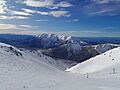
Porters Ski Area is located in the Craigieburn Range in the South Island of New Zealand. This mountain range is about 85 km northwest of Christchurch. It is also about the same distance from both the west and east coasts of the South Island. The Craigieburn Range stretches for 26 km from northeast to southwest.
The mountains here are made of old, folded sandstones and siltstones. This gives them rounded tops. Many slopes have loose rocks, called scree, because the bedrock is broken up. Long ago, glaciers covered these valleys. But now, rivers and falling rocks have changed the landscape a lot. About 80% of the ski area is covered in these loose rocks. The rest has alpine plants.
Porters Ski Area by the Numbers
How High is Porters?
- The highest point (Summit) is 1995 meters (6545 feet) high. 43°15′45″S 171°37′53″E / 43.26259°S 171.63129°E
- The lowest point (Base) is 1302 meters (4272 feet) high. 43°16′26″S 171°38′34″E / 43.273792°S 171.642778°E
Ski Lifts at Porters
Porters has a total of 6 lifts to get you up the mountain:
- 3 T-Bars: These lifts pull you up the slope while you stand on your skis or snowboard.
- T-Bar 3 goes from 1740 m to 1955 m. 43°16′20″S 171°37′45″E / 43.272094°S 171.629146°E
- T-Bar 2 goes from 1580 m to 1780 m. 43°16′15″S 171°37′59″E / 43.270868°S 171.63318°E
- T-Bar 1 goes from 1305 m to 1625 m. 43°16′23″S 171°38′34″E / 43.273094°S 171.642707°E
- 1 Quad Chairlift: This lift has chairs that carry four people. It replaced a T-bar in 2015. It can carry 2000 people every hour.
- 1 Platter Lift: This lift has a disc (platter) that you place between your legs to be pulled up. It goes from 1305 m to 1340 m. 43°16′21″S 171°38′38″E / 43.272461°S 171.643887°E
- 1 Magic Carpet: This is like a moving conveyor belt for beginners. 43°16′19″S 171°37′45″E / 43.272079°S 171.629146°E
Ski Trails at Porters
Porters has many different ski trails for all skill levels. Here are some of them:
| Trail Name | Skill Level | Length | What it's like |
|---|---|---|---|
| Beginner Area |
|
0.1 km | A gentle area for new skiers, right above the car park. |
| Easy Street |
|
1.1 km | An intermediate trail also near the car park. |
| Intermediate Area |
|
0.2 km | A small area for those learning intermediate skills. |
| Dome Face |
|
1.2 km | A large open slope above the old cafe. |
| Big Mama |
|
1.2 km | A wide open slope next to Dome Face, leading to the base. |
| Babylon |
|
0.3 km | A small open slope that branches off the main ridge. |
| Ridge Route |
|
0.8 km | A long open slope coming down from the main ridge. |
| Julian's Bowl |
|
0.5 km | A Y-shaped bowl below T-Bar 3. |
| Headwall |
|
0.5 km | A large open slope to the right of T-Bar 3. |
| Sundance Basin |
|
0.7 km | A groomed run for T-Bar 3, on the left side of the lift line. |
| JC's |
|
0.4 km | A slope from the main T-Bar 3 run into the bowl. |
| Leaper |
|
0.9 km | A slope between a large rock and the top of T-Bar 2. |
| Aorangi Chutes |
|
0.6 km | An area with many narrow gullies and rocky spots above T-Bar 1. |
| Solitude |
|
0.6 km | A slope between rocky areas and McNulty's Saddle. |
| McNulty's Basin |
|
2.0 km | The longest groomed trail, starting from the top of T-Bar 3. |
| Serpent |
|
0.3 km | A slope below the saddle and the start of the ridge walk. |
| Jelly Roll |
|
0.5 km | The middle part of the ridge walk to Bluff Face. |
| Pot Belly |
|
0.5 km | A steep open slope in McNulty's Basin, below 'Allison Peak'. |
| Uli's Roll |
|
0.5 km | Located in McNulty's Basin, below 'Allison Peak'. |
| Zodiac Traverse |
|
0.7 km | A wide open section below the Allison Peak summit. |
| Scorpio |
|
0.7 km | A large open slope in McNulty's Basin, next to rocky areas. |
| Libra |
|
0.7 km | An open slope between two rocky ridges. |
| Stellar Bowl |
|
0.3 km | An area below a triangular group of rocks. |
| Stan's |
|
0.4 km | A slope directly below a low rock buttress. |
| Pisces |
|
0.3 km | A slope directly below the lowest rock on a small ridge. |
| Bluff Face |
|
1.2 km | A large open face on the left side of the ski area with big rocks. |
| Laurie's Face |
|
0.5 km | A large open slope below the skyline ridge. |
| Don't Miss |
|
0.5 km | A challenging slope on the left of the car park with many rocks and gullies. |
| Sphinx |
|
0.4 km | Located on the slopes above the snow groomer workshop. |
Weather at Porters
Porters Ski Area gets snow from two main types of storms. One type brings winds from the west or northwest, then cooler winds from the south or southwest. The other type is a storm that moves across New Zealand. This brings moist air from the east or southeast to the Craigieburn region. Most of the snow at Porters comes from these storms.
The coldest temperature ever recorded at Porters Ski Area was -15.37°C (4.33°F). This happened on August 14, 2011.
| Climate data for Porters Area Ski @ 1,320 m | |||||||||||||
|---|---|---|---|---|---|---|---|---|---|---|---|---|---|
| Month | Jan | Feb | Mar | Apr | May | Jun | Jul | Aug | Sep | Oct | Nov | Dec | Year |
| Record high °C (°F) | 26.6 (79.9) |
26.0 (78.8) |
24.7 (76.5) |
19.3 (66.7) |
15.9 (60.6) |
13.5 (56.3) |
14.2 (57.6) |
15.8 (60.4) |
16.0 (60.8) |
18.4 (65.1) |
23.4 (74.1) |
23.8 (74.8) |
26.6 (79.9) |
| Mean daily maximum °C (°F) | 22 (72) |
22 (72) |
21 (70) |
16 (61) |
14 (57) |
9 (48) |
9 (48) |
13 (55) |
13 (55) |
15 (59) |
22 (72) |
23 (73) |
17 (62) |
| Daily mean °C (°F) | 11 (52) |
11 (52) |
10 (50) |
7 (45) |
4 (39) |
2 (36) |
1 (34) |
2 (36) |
4 (39) |
4 (39) |
7 (45) |
9 (48) |
6 (43) |
| Mean daily minimum °C (°F) | 0 (32) |
−1 (30) |
−1 (30) |
−3 (27) |
−5 (23) |
−8 (18) |
−7 (19) |
−7 (19) |
−6 (21) |
−4 (25) |
−3 (27) |
−1 (30) |
−4 (25) |
| Record low °C (°F) | −2.3 (27.9) |
−0.8 (30.6) |
−4.4 (24.1) |
−5.3 (22.5) |
−7.2 (19.0) |
−8.3 (17.1) |
−10.9 (12.4) |
−11.4 (11.5) |
−8.0 (17.6) |
−7.6 (18.3) |
−5.9 (21.4) |
−4.2 (24.4) |
−11.4 (11.5) |
| Average precipitation mm (inches) | 62 (2.4) |
94 (3.7) |
40 (1.6) |
82 (3.2) |
131 (5.2) |
157 (6.2) |
132 (5.2) |
149 (5.9) |
104 (4.1) |
125 (4.9) |
61 (2.4) |
92 (3.6) |
1,229 (48.4) |
| Average precipitation days | 13 | 12 | 11 | 11 | 12 | 17 | 16 | 18 | 18 | 16 | 11 | 15 | 170 |
| Average relative humidity (%) | 67 | 69 | 68 | 70 | 69 | 66 | 66 | 70 | 66 | 66 | 67 | 72 | 68 |
| Source: Data from an automatic weather station between 2005 and October 2015 | |||||||||||||
Plants at Porters Ski Area
You can find 187 different types of plants within the ski field area.
- Porters Ski Area (2023)
-
Sundance Valley (2023)
-
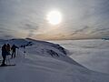
View from the top of the ski field above the clouds (2023)


Animals at Porters Ski Area
During the summer, five types of grasshoppers live within the ski field area.
- Sigaus villosus lives along the mountain ridges.
- Brachaspis nivalis can be found on the rocky scree slopes.
- Sigaus australis and Paprides nitidus both live in the alpine tussocklands (grassy areas).
- Phaulacridium marginale lives in the tussocklands below 1,100 meters.
