
Portsbridge Creek facts for kids

Portsbridge Creek (also known as Portcreek or Ports Creek) is a natural waterway in southern England. It separates Portsea Island, where the city of Portsmouth is located, from the mainland. This tidal creek connects Langstone Harbour to Tipner Lake. Over time, people have worked to make it easier to travel through, and today, small boats can still use it.
Contents
History of Portsbridge Creek
Portsbridge Creek, especially where it could be crossed, has been an important defensive spot for a very long time. People think defenses might have been built here as far back as the time of Henry VIII.
Defenses and the English Civil War
During the English Civil War, royalist soldiers tried to stop the parliamentarian forces at the creek. This happened early in the Siege of Portsmouth. The defenses included a wooden barrier on the bridge and a small fort with four cannons. However, the cannons were removed on August 10, 1642. With only eight men guarding the barrier, the parliamentarian forces managed to cross the creek just two days later.
Plans from 1660 and 1666 show a fort at the creek's crossing point. This fort was rebuilt in 1688 by Sir Martin Beckman, who was a top engineer for the King.
Some people believe that a customs officer in Cosham was there to stop illegal goods from being brought in by boat through Portsbridge Creek.
In 1830, a company called Portsmouth & Arundel Navigation made the waterway easier to travel through. This happened after an earlier canal, the Portsmouth and Arundel Canal, didn't work out. It cost £1,000 to make the creek deeper.
However, it was hard to keep the creek clear for boats. A new canal, called the Cosham Canal, was suggested as another route, but it was never built. The canal company stopped using the creek in 1838.
An army report in 1853 said the creek was so full of weeds that people could walk across it for several hours each day. Later in the 1850s, as part of upgrades to the Hilsea Lines defenses, the creek was made wider and deeper. This allowed gunboats to use it. Dams and flood gates were built at both ends of the creek. This helped keep water in the creek no matter the tide. You can still see parts of one of these old dams at the eastern end of the creek.
In 1963, there was an idea to rename it the Dunkirk Memorial Channel. In the late 1960s, part of the creek was used to build the A27 road. The rest of the creek was dug out to make it deeper. These changes, along with other improvements, made the creek navigable for small boats again. In 2015, new flood defenses were built along the creek.
Bridges over Portsbridge Creek
Many bridges have been built across Portsbridge Creek over the years. The first record of a bridge here is from the late 1100s.
Early Bridges
In the 1400s, a stone bridge with two arches was built at the western end of the creek. In 1867, a new retractable bridge was built for £5,000. This bridge could open to let gunboats pass through. It was made of steel with a wooden deck and had two lanes, each about 12 feet (3.7 meters) wide.
In 1904, the bridge was given to the Portsmouth Corporation (which later became Portsmouth City Council). They fixed it in place and made it stronger so that trams could cross it. This bridge was replaced by a wider one in 1927. The current twin-bridge roundabout structure was built in 1970 when the A27 road was constructed.
Railway Bridges
The London, Brighton and South Coast Railway built a wooden bridge across the creek in 1847. This was replaced by a swing bridge in 1870. A special order from the Admiralty (the navy department) required this bridge to open for boats between 2 and 3 AM on the first Sunday of every February.
The swing bridge was replaced by a drawbridge in 1909. This drawbridge has been fixed in place since 1920. The railway tracks just north of the current bridge are called Portcreek Junction. This junction is part of a railway triangle, with Cosham Junction to the west and Farlington Junction to the east.
Other Crossings
A bridge was added at the eastern end of the creek in 1941. This is now known as the Eastern Road (Water) Bridge. Another crossing, called Peronne Road, was built during World War II. It was a causeway, meaning the creek flowed through only a small pipe underneath. This was later replaced by a high footbridge when the A27 was built.
Images for kids
-
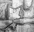
A plan of the fort defending the creek's crossing in 1660
-
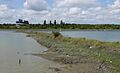
The remains of one of the dams built in the 1850s
-
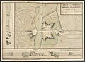
Plan and profiles of Portsea Bridge Fort, 1747 (by J. P. Desmaretz).


