
Langstone Harbour facts for kids
| Site of Special Scientific Interest | |
 |
|
| Area of Search | Hampshire |
|---|---|
| Interest | Biological |
| Area | 2,085.4 hectares (5,153 acres) |
| Notification | 1985 |
| Location map | Magic Map |
Langstone Harbour is a large natural inlet of the English Channel in Hampshire, England. It covers about 2,085 hectares (over 5,100 acres) and is a very important place for nature. Because of its special wildlife, it's known as a Site of Special Scientific Interest (SSSI).
The harbour is located between Portsea Island (where Portsmouth is) to the west, Hayling Island to the east, and the village of Langstone to the north. It's connected to Chichester Harbour and Portsmouth Harbour, forming a chain of important waterways. These harbours are used for fun activities like boating, but they are also vital for wildlife and some fishing.
Langstone Harbour is managed by the Langstone Harbour Board. It's part of bigger protected areas like the Chichester and Langstone Harbours Ramsar site (important wetlands), a Special Protection Area for birds, and a Nature Conservation Review site. Some parts are also Local Nature Reserves, like Farlington Marshes, West Hayling, and The Kench, Hayling Island. The Hampshire and Isle of Wight Wildlife Trust also looks after Farlington Marshes and Southmoor Nature Reserve.
Contents
Islands of Langstone Harbour
Langstone Harbour has several islands that are important for wildlife. These include Baker's Island, North Binness Island, South Binness Island, and Long Island. There are also two smaller islands: Round Nap Island, which connects to South Binness Island at low tide, and Oyster Island.
Over time, these islands have been slowly worn away by the sea. In the 1990s, a long project took place to study their history before more of it was lost to erosion.
History of Langstone Harbour
Langstone Harbour was once a river valley. After the last ice age, sea levels rose. Around 4000 to 3500 BC, the area became the harbour we know today.
For many years, people used the harbour to make salt. The Domesday Book, a famous survey from 1086, mentions three salt-making sites around the harbour. By the 1600s, a large saltworks at Copnor was busy. Here, the shallow water made it easy to get salt from the sea after each tide. Salt production continued in the harbour until 1933.

In 1771, a large area called Farlington Marshes was reclaimed from the northern part of the harbour. This means land was taken from the sea.
People started Oyster farming in the harbour around 1820. They also grew winkles and clams. This farming stopped in the 1950s. An attempt to restart oyster farming in the 1980s didn't work out. In 1997, work began to turn the old oyster beds into an artificial lagoon. This lagoon has a small island in the middle and has become a great place for birds to breed, especially little terns.
During the Second World War, Langstone Harbour was used as a "Starfish decoy site." This meant it was set up to look like a city from the air at night. The idea was to trick German bombers into dropping their bombs there instead of on real towns.
Amazing Wildlife
Langstone Harbour is home to a huge variety of marine life and birds. Scientists have found fifty different types of fish in the harbour. The bird life is even richer. Many species of birds live here, with some groups having over 10,000 individuals!
This is partly because the Royal Society for the Protection of Birds (RSPB) bought the harbour's islands and some tidal areas in 1978. They turned these places into bird sanctuaries. Because so many birds visit, the harbour is a very popular spot for bird watchers.
Sometimes, seals visit the harbour in winter. You can also find American hard-shelled clams here. These clams spread from where they were first released in the lower River Test. The harbour also has a population of Sand smelt, which are small fish.
In 2008, a large northern bottlenose whale got stuck in the mudflats of Langstone Harbour. It was 8 meters (26 feet) long and weighed 7 tonnes. A rescue team tried to save the whale. They managed to free it from the mud, but it stayed in shallow water. Sadly, a blood test showed the whale was very sick with kidney failure. A difficult decision was made to humanely end its suffering. The whale had traveled about 3,000 miles (4,800 km) off course because of its illness.
Harbour Wrecks
There are several old boat wrecks in Langstone Harbour. One wreck is a tugboat called the Irishman. It sank on May 8, 1941, after hitting a magnetic mine. Part of it can still be seen at low tide.
Another older wreck, from 1926, is a bucket dredger named the Withern. A dredger is a boat that digs up mud from the bottom of the water. The Excelsior, an 80-foot-long barge, is also wrecked here, but its age is unknown. The harbour also has a wrecked landing craft. Its front part is almost always visible above the water.
Near the entrance of the harbour, there is a wrecked Phoenix breakwater type C. These were large concrete structures built during World War 2 to create temporary harbours for ships, known as Mulberry Harbours.
People have also found various items from the old prison hulks that were kept in the harbour during the Napoleonic Wars. Prison hulks were old ships used as floating prisons.
Images for kids
-
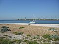
Entrance to Langstone Harbour

