
Hayling Island facts for kids

The coastline of Hayling Island
|
|

Hayling Island
Location in Hampshire
|
|
| Geography | |
|---|---|
| Location | Solent |
| Coordinates | 50°48′10″N 0°58′30″W / 50.80278°N 0.97500°W |
| Total islands | 1 |
| Area | 30 km2 (12 sq mi) |
| Length | 6.5 km (4.04 mi) |
| Width | 6.5 km (4.04 mi) |
| Administration | |
|
England
|
|
| County | Hampshire |
| Borough | Havant |
| Largest settlement | Mengham (town) |
| Demographics | |
| Population | 17,379 (2011) |
| Pop. density | 562.9 /km2 (1,457.9 /sq mi) |
Hayling Island is a lovely island located off the south coast of England. It's part of the Havant area in Hampshire county, just east of Portsmouth. It's a popular spot for holidays and water sports!
Contents
A Look Back: Hayling's History

Ancient Times: Roman Temple and Salt
Long, long ago, in the Iron Age, people built a special shrine on Hayling Island. Later, around the 1st century BC, the Romans turned it into a temple. This temple was first written about in a book in 1826.
Archaeologists dug up the site between 1897 and 1907, and again from 1976 to 1978. Today, you can't see the remains of the temple because they are buried under farmland.
Hayling Island was also famous for making salt! This industry started in the 11th century. The Domesday Book, a very old record, even mentions a place for making salt on the island. Salt production continued here until the late 1800s.
Old Churches and Famous Graves
Construction of Northwode Chapel began around 1140. This chapel later became the current St Peter's Church. It is the oldest church still standing on the island today. Some people believe its three bells, made around 1350, are among the oldest in England!
St Mary's Church is another old church. Its walls are made from a mix of local shells and beach pebbles. In its churchyard, there's an ancient yew tree. It's thought to be the oldest yew tree in the country! Its trunk is about nine metres (30 feet) around. Experts think it could be over a thousand years old, maybe even two thousand!
You can also find the grave of Princess Yourievsky (1878–1959) in St. Peter's churchyard. She was part of the Russian Royal family and lived in North Hayling for many years.
World War II Practice and a Big Invention
In May 1944, during World War II, Hayling Island was used for a practice invasion called Exercise Fabius. This was a rehearsal for the real D-Day landings.
Something really cool happened on Hayling Island in 1958. A young boy named Peter Chilvers put together a board with a sail. This was the very first windsurfer! It had all the main parts of modern windsurfers. Later, in 1982, British courts agreed that Peter Chilvers' invention was the original idea for windsurfing. This case was important for patent law in the UK.
Recent Events
On October 20, 2013, a tornado hit Hayling Island. It damaged at least one hundred homes. Luckily, no one was hurt.
Exploring Hayling's Geography
Hayling Island is a "true island" because it's completely surrounded by the sea. It's shaped a bit like an upside-down 'T'. It's about 6.5 km (4 miles) long and 6.5 km (4 miles) wide.
A road bridge connects the north end of the island to the mainland at Langstone. There's also a small boat called the Hayling Ferry. It takes people and bikes to the Eastney area of Portsmouth on Portsea Island. To the west of Hayling is Langstone Harbour, and to the east is Chichester Harbour.
The beaches on Hayling were naturally sandy. But to stop the beach from washing away and to protect low-lying land from floods, shingle (small stones) from the sea bed has been added. When the tide is low, you can see the East Winner sandbank. It stretches out about a mile into the sea!
Weather on Hayling Island
Hayling Island has a maritime climate. This means it has cool summers and mild winters. Temperatures here are quite mild, similar to the far southwest of England and the nearby Isle of Wight. The coldest it has ever been since 1960 is −9.4 °C (15.1 °F) in January 1963. The hottest was 32.1 °C (89.8 °F) in June 1976.
| Climate data for Hayling Island 4 m (13 ft) asl, 1981–2010, extremes 1960–2010 | |||||||||||||
|---|---|---|---|---|---|---|---|---|---|---|---|---|---|
| Month | Jan | Feb | Mar | Apr | May | Jun | Jul | Aug | Sep | Oct | Nov | Dec | Year |
| Record high °C (°F) | 13.7 (56.7) |
14.9 (58.8) |
20.0 (68.0) |
24.3 (75.7) |
27.4 (81.3) |
32.1 (89.8) |
31.7 (89.1) |
31.4 (88.5) |
27.2 (81.0) |
21.7 (71.1) |
17.5 (63.5) |
14.6 (58.3) |
32.1 (89.8) |
| Mean daily maximum °C (°F) | 8.0 (46.4) |
7.9 (46.2) |
10.2 (50.4) |
12.9 (55.2) |
16.3 (61.3) |
19.1 (66.4) |
21.3 (70.3) |
21.3 (70.3) |
18.8 (65.8) |
15.1 (59.2) |
11.3 (52.3) |
8.6 (47.5) |
14.2 (57.6) |
| Mean daily minimum °C (°F) | 3.4 (38.1) |
3.0 (37.4) |
4.6 (40.3) |
6.1 (43.0) |
9.2 (48.6) |
12.1 (53.8) |
14.4 (57.9) |
14.5 (58.1) |
12.4 (54.3) |
9.7 (49.5) |
6.2 (43.2) |
3.8 (38.8) |
8.3 (46.9) |
| Record low °C (°F) | −9.4 (15.1) |
−8.9 (16.0) |
−5.6 (21.9) |
−2 (28) |
−0.6 (30.9) |
2.2 (36.0) |
7.8 (46.0) |
7.2 (45.0) |
4.2 (39.6) |
−0.2 (31.6) |
−4.6 (23.7) |
−7.2 (19.0) |
−9.4 (15.1) |
| Average precipitation mm (inches) | 75.02 (2.95) |
50.41 (1.98) |
53.43 (2.10) |
45.56 (1.79) |
43.66 (1.72) |
39.62 (1.56) |
43.55 (1.71) |
43.71 (1.72) |
58.66 (2.31) |
88.41 (3.48) |
82.08 (3.23) |
79.06 (3.11) |
703.17 (27.66) |
| Source: Royal Dutch Meteorological Institute/KNMI | |||||||||||||
Fun and Games: Sports and Leisure
Hayling Island is a great place for sports and fun activities!
Water Sports and Sailing
The island is famous for windsurfing and sailing. In fact, windsurfing was invented here!
The Hayling Island Sailing Club is a very active place. In 2010, it hosted the World Laser Standard Senior and Junior Championships. Many different types of sailing happen here.
Because water activities are so popular, there are two lifeboat services on the island. The Hayling Island Lifeboat Station is run by the RNLI. There's also an independent service called Hayling Island Rescue Service.
Tennis and Golf
Hayling Island has one of the few active Real Tennis courts in the UK. This club, called Seacourt Tennis Club, opened in 1911. It's one of the few places where you can play almost every type of racquet sport! The club also has a weekly fencing club for all ages.
Hayling Golf Club is a top golf course. It's known for its strong winds, fast greens, and challenging bunkers.
Amusement Park and Theatre
Funland is an amusement park at Beachlands. It's open all year round! The East Hayling Light Railway is a small train that runs from the funfair to Eastoke corner.
The Station Theatre hosts many plays by local groups like the Hayling Island Amateur Dramatics Society. You can also see musicals and films there.
Getting Around Hayling Island


The Hayling Ferry
The Hayling Ferry connects Hayling Island to Portsmouth. It's very popular in summer, bringing tourists and cyclists to the island. The ferry stopped running for a while in 2015 but reopened in August 2016.
Road and Old Railway
The only road connection between Hayling Island and the mainland is a single road. In summer, this road can get very busy!
There used to be a railway line on the island. It opened in 1867 and was called the Hayling Billy Line. Steam trains carried people from Havant Station on the mainland to a station on the island. The railway was very popular with tourists in summer.
However, the old bridge connecting the island to the mainland needed expensive repairs. So, the railway closed in 1963, and the bridge was taken down in 1966.
Today, some old railway buildings remain. A goods shed has been turned into the theatre. There's also a tourist train called the East Hayling Light Railway. It's a small railway that runs for over 1 mile (1.6 km) along the coast.
The closest main train station to Hayling Island is Havant.
Hayling's Oyster Beds

People have been fishing for oysters at the Hayling oysterbeds for a very long time, even since Roman times! Records show oyster fishing here since 1615. Oysters were actively farmed from the early 1800s until the 1970s. These "Emsworth Oysters" were a special treat sent all over the country.
Large areas with walls and gates were built to hold the oysters as they grew. Even though some walls have fallen, you can still see the shape of these old oyster beds today.
In 1996, the oyster beds were cleaned up and restored. Now, they are a special place for wildlife, especially seabirds. This project was even given an award for its great renovation!
Charity Cycle Ride
Hayling Island is home to the Hayling Charity Cycle Ride. This event organizes an annual bike ride, often from Hayling Island all the way to Paris and back! Local volunteers run this event, which started in 1986. By 2018, it had raised over £1,700,000 for more than 500 good causes! People from many different countries have joined the ride.
Hayling Island's Population
In the past, Hayling Island's population would double in summer because of all the holidaymakers. Now, it only grows by about 20% to 25% during the summer months.
| Population | Date |
|---|---|
| ~300 | 1086 (Domesday Book) |
| 578 | 1801 (census) |
| >1,600 | 1901 |
| >5,500 | 1950 |
| 16,887 | 2001 (census) |
| 17,379 | 2011 (census) |
Places to See on Hayling Island
- East Hayling Light Railway
- Funland
- Hayling Billy Trail (a walking path on an old railway line)
- Hayling Island Sailing Club
- Northney Marina
- Seacourt Tennis Club
- Sparkes Marina
- Station Theatre
- St. Mary's Church
- St. Peter's Church, Northney
- The Hayling Ferry
- The Kench
- The RNLI Lifeboat station
Images for kids
-
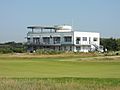
Hayling Golf Club clubhouse
-
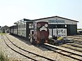
Hayling Seaside Railway
-
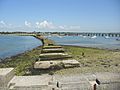
Remains of the old railway bridge linking Hayling Island to the mainland. The present road bridge can be seen to the right.


