
Portsea Island facts for kids

Closeup map of Portsea Island
|
|

Portsea
Location in Hampshire
|
|
| Geography | |
|---|---|
| Location | Solent |
| Coordinates | 50°48′09″N 01°04′12″W / 50.80250°N 1.07000°W |
| Area | 24.542 km2 (9.476 sq mi) |
| Administration | |
|
England
|
|
| County | Hampshire |
| City | Portsmouth |
| Demographics | |
| Population | 207,100 (2010) |


Portsea Island is a flat island located off the southern coast of England. It covers about 24.5 square kilometers (9.5 square miles). Most of the city of Portsmouth is built on this island.
Portsea Island has a very large population for an island. It is the third most populated island in the British Isles, after Great Britain and Ireland. It also has the highest population density of any British island. This means a lot of people live in a small area. Portsmouth itself has the highest population density of any city in the UK, except for London.
To the east of Portsea Island, you'll find Hayling Island, separated by Langstone Harbour. To the west, the mainland town of Gosport is across Portsmouth Harbour. To the south, the island faces the Spithead area of Solent. A narrow water channel called Portsbridge Creek runs along the northern edge, separating Portsea Island from the mainland.
Contents
- Connecting to the Mainland
- Island Travel Options
- Island History and Heritage
- Exploring Portsea Island's Neighborhoods
- Portsea: A Historic Area
- Southsea: A Lively Coastal Spot
- Fratton: A Residential Hub
- Anchorage Park: A Modern Area
- Baffins: Green Spaces and College Life
- Buckland: Central Island Living
- Eastney: Coastal Forts and Ferries
- Landport: Dickens' Birthplace
- Kingston: A Quiet Residential Area
- Old Portsmouth: The Original Town
- North End: A Residential Hub
- Hilsea: Sports and Industry
- Stamshaw: Parks and Pathways
- Tipner: A Northwest Corner
- Milton: Village to City Suburb
- Copnor: An Expanding Village
- Images for kids
Connecting to the Mainland
Portsea Island is well-connected to the rest of England. Three main roads link it to the mainland: the M275 motorway, the A3 London Road, and the A2030 Eastern Road. There are also two smaller bridges for people walking or cycling over Portsbridge Creek.
Inside Portsmouth Harbour, a road bridge connects Portsea Island to Whale Island. This island is a special base for the Royal Navy.
Island Travel Options
The island has four railway stations: Portsmouth Harbour, Portsmouth & Southsea, Fratton, and Hilsea. These stations are part of a branch line that connects to the mainland railway network using a short bridge over Portsbridge Creek.
You can also travel by ferry from Portsea Island. Ferries go to Gosport (on the mainland), Hayling Island, and the Isle of Wight. There are also ferries that travel further, to the Channel Islands, northern France, and northern Spain.
The name "Portsea Island" also refers to a historic area of Portsmouth called Portsea and the Portsea Parish.
Island History and Heritage
Portsea Island has a long and interesting past.
- Ancient Discoveries: Two collections of items from the Bronze Age have been found here. Roman coins have also been discovered.
- Viking Raids: In 979 AD, the island was attacked by Vikings from Denmark.
- Early Settlements: The Domesday Book, a famous survey from 1086, recorded three main settlements on the island.
Exploring Portsea Island's Neighborhoods
Portsea: A Historic Area
Portsea is a specific area within the city of Portsmouth, located in the southwest part of the island.
Famous People from Portsea
Many famous people were born in or near Portsea:
- Isambard Kingdom Brunel, a brilliant engineer, was born here in 1806.
- Writer Charles Dickens was born nearby in Landport on February 7, 1812.
- Professor William Garnett was born in Portsea on December 30, 1850.
Growth of Portsea
This area was first known as the "Common." It was located between the town of Portsmouth and the dockyard. People started building houses here in the late 1600s because the old town was getting too crowded. At first, the dockyard governor was worried about new buildings blocking the view for cannons. But after a request to Queen Anne, building was allowed in 1704. In 1792, the area's name changed from the Common to Portsea. By then, it was a busy area with people connected to the docks.
Modern Portsea
In the early 1900s, Portsmouth council began to improve the housing in Portsea. The city's first council houses were built here in 1911. In the 1920s and 1930s, many older, less well-built homes were replaced with new council houses.
During World War II, the area suffered a lot of bomb damage because it was so close to the dockyard. After the war, Portsea was rebuilt with new council housing, including houses, maisonettes, and tall apartment buildings.
Southsea: A Lively Coastal Spot
Southsea is located at the southern end of Portsmouth on Portsea Island. It's very close to Portsmouth's city center and its harbor. Southsea has a busy shopping area with large department stores and many smaller, independent shops.
From 1999 to 2010, Southsea had its own separate town council. Now, it is part of the Portsmouth City Council again.
Southsea's Railway History

From 1885, Southsea had its own railway line called the Southsea Railway. It had three stations: Jessie Road Bridge Halt, Albert Road Bridge Halt, and a final station called East Southsea. The railway line started from Fratton Station.
The Southsea Railway closed in 1914 because it couldn't compete with trams. The tracks and stations were removed, and roads and houses were built in their place. Even today, if you look at a modern map of Portsmouth, you can still see the path of the old railway line in how the roads and houses are arranged.

Fratton: A Residential Hub
Fratton is a residential area in Portsmouth. It mainly has Victorian terraced houses, which are common in the city. In the past, it had a very large railway depot, but most of it has been taken down. This area now has a shopping complex and the redeveloped stadium for Portsmouth F.C., called Fratton Park.
Fratton also has a shopping center called The Bridge Centre on Fratton Road. It has a large Asda supermarket and smaller, local shops and cafes. Its railway station is one of the four stations on the island.
Anchorage Park: A Modern Area
Anchorage Park is a newer part of the island in the northeast. It's next to one of the island's largest green areas, which includes allotments (small plots of land for gardening), sports fields, and a golf course. Anchorage Park used to be the location of Portsmouth Airport, which closed in 1973.
Baffins: Green Spaces and College Life
Baffins is next to a large green area and has a big pond. It is also home to the grounds of Portsmouth College.
Buckland: Central Island Living
Buckland is a central neighborhood in the heart of the island. It is located south of North End and northeast of Landport.
Eastney: Coastal Forts and Ferries
Eastney is along the beach on the southern shore. It has a promenade road and three forts: Eastney Fort West (which is no longer used), Eastney Fort East, and the large Fort Cumberland. Fort Cumberland is on a small piece of land that sticks out into the water. Eastney is the most southeastern part of Portsea Island and is near the entrance to Langstone Harbour. Eastney also has a marina and a ferry service for people walking across Langstone Harbour to Hayling Island.
Landport: Dickens' Birthplace
Landport has residential areas and business premises near its Albert Johnson Quay. In the westernmost street of the residential side, you can find a large old listed horse trough and a row of four listed homes. One of these homes is the Charles Dickens Birthplace Museum, where the famous writer was born.
Kingston: A Quiet Residential Area
This small, central district is mostly residential with terraced houses. It also has a few taller apartment buildings.
Old Portsmouth: The Original Town
Old Portsmouth is located on the southwest corner of Portsea Island. It forms the eastern side of the narrow entrance to Portsmouth Harbour, which is known as the ports mouth. Old Portsmouth has most of the traditional High Street and historical buildings of the original old town of Portsmouth. This includes Portsmouth Point (also called 'Spice Island') and the Camber Dock.
North End: A Residential Hub
North End is mainly a residential area located in the center-north of the island.
Hilsea: Sports and Industry
Hilsea is the northwestern district of the city. It has a mix of homes and areas for businesses, shops, and distribution. It is home to one of Portsmouth's main sports and leisure centers, the Mountbatten Centre, and Trafalgar School. It also has small green areas to the north and west, including the Portsmouth rugby football club.
Stamshaw: Parks and Pathways
Stamshaw is a residential area with terraced streets. It includes Alexandra Park, which has the Mountbatten Sports Centre. It is also home to the Portsmouth Ferry Terminal. To the north are Tipner and Hilsea, and to the south are Kingston, Buckland, and Commercial Road, which is the main shopping area of the city. Stamshaw is bordered to the west by the M275 motorway and Whale Island. To the east is North End. The main roads in Stamshaw, Twyford Avenue and Stamshaw Road, are part of a one-way traffic system.
Stamshaw has an infant and junior school. Its park, next to the road leading to the city center, has large fields and an adventure playground.
Tipner: A Northwest Corner
This small northwestern part of the island includes a public parkland point called Tipner Point. It has a mix of road uses, shops, distribution centers, and homes.
Milton: Village to City Suburb
Milton is mainly a residential area in Portsmouth. It has two large public parks: Milton Park and Bransbury Park. The area is on the southeastern side of Portsea Island and is bordered on the east by Langstone Harbour. Eastney is to the south, Southsea to the southwest, Baffins to the north, and Fratton to the west.
Milton was originally a small village on Portsea Island, surrounded by farmland. It became part of the city as Portsmouth grew in the early 1900s. Portsmouth Football Club's Fratton Park stadium, despite its name, is actually located in the Milton Ward area of Portsmouth, south of the city's railway line.
Copnor: An Expanding Village
Copnor is an area on the eastern side of Portsea Island. It was one of the three villages listed on Portsea Island in the Domesday Book, where it was called Copenore.
In the late 1800s and early 1900s, Portsmouth grew quickly, and the original village of Copnor was absorbed into the city. The western part of the district is now mostly homes built in the 1930s. The eastern part is an area for industry and businesses.
There were plans for a railway station in Copnor when the line between Havant and Portsmouth Town opened. However, this station was never built, even though there was a large gap between stations and a signaled level crossing for many years (now a bridge). A "Station Road" was laid out and still exists, but construction on the station never began.
Images for kids
-
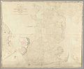
Map of the Island of Portsea, dated 1773.
-
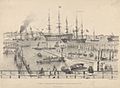
The Common-Hard, Portsmouth, in 1834, with HMS Victory in the harbor.


