Milton, Portsmouth facts for kids
Quick facts for kids Milton |
|
|---|---|
| Suburb | |
| Population | 14,111 |
| OS grid reference | SZ 66433 99895 |
| Unitary authority | |
| Ceremonial county | |
| Region | |
| Country | England |
| Sovereign state | United Kingdom |
| Post town | SOUTHSEA |
| Postcode district | PO4 |
| Dialling code | 023 |
| Police | Hampshire |
| Fire | Hampshire |
| Ambulance | South Central |
| EU Parliament | South East England |
| UK Parliament |
|
Milton is a lively part of the city of Portsmouth, Hampshire, England. It's located on the south-eastern side of Portsea Island. Milton is surrounded by Langstone Harbour to the east. Other nearby areas include Eastney to the south-east, Southsea to the south-west, Baffins to the north, and Fratton to the north-west.
The name 'Milton' comes from an old Saxon word, Middletūn. This means "middle settlement". It was called this because it was in the middle of two older Saxon villages: Froddington (now Fratton) and Eastney. After 1066, when the Normans arrived, it was known as Middleton. Over many years, people started saying "Milton" instead of Middleton.
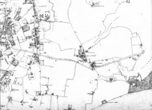
Milton began as a small village on Portsea Island. It was surrounded by farms where people grew crops and vegetables. In 1904, Portsmouth grew bigger and included all of Portsea Island. This is when Milton officially became part of Portsmouth.
Today, Milton is known as Milton Ward in the Portsmouth City Council. This means it's an area that elects its own representatives to help run the city. Milton Ward is also part of the Portsmouth South area for the UK Parliament. In 2011, about 14,111 people lived in Milton Ward.
Contents
Milton's Interesting Past


Milton still feels a bit like a village, even though it's part of a city. It has two big public parks: Milton Park and Bransbury Park. Both of these parks used to be farms. Milton was a small village with lots of farmland until Portsmouth expanded and took it over in the late 1800s and early 1900s.
The Old Canal and New Roads
In the early 1800s, a canal was built through Milton. This canal was part of the Portsmouth and Arundel Canal. It helped boats travel across Portsea Island.
Today, Milton Park is on land that used to be Purnell Farm. This farm became part of the Goldsmith family's Milton Farm estate in 1808. They later renamed it Middle Farm. In 1911, the Goldsmith family's estate was divided. The city of Portsmouth bought Middle Farm in 1912. It was then opened as Milton Park in 1923 for everyone to enjoy.
Some of the Goldsmith family are buried in St James churchyard, which is across the road from Milton Park. One of the original Middle Farm buildings is still there. It's a thatched barn that has been made bigger and is now used by a theatre group called the Portsmouth Players.
Milton Locks is in the far east of Milton, at the end of Locksway Road. This was where the Portsmouth and Arundel Canal met Langstone Harbour. The canal started working in 1822 but was later abandoned. Not much is left of the old wooden lock gates, but you can still see where the canal used to be.
Several pubs are located along the old canal path. This shows the route the canal took towards Landport. The railway line from Fratton to Portsmouth and Southsea railway station actually runs along the old canal bed. You can see this easily from a street called Canal Walk, near Fratton Bridge.
When the canal closed in the mid-1800s, the part in Milton was filled in. This created a new main road called Goldsmith Avenue. It was named after the Goldsmith family, who owned a lot of land there.
Parks and Shops in Milton
Bransbury Park was once Bransbury Farm until 1911. It was also part of the Goldsmith family's land. Portsmouth council bought it, and the farm and nearby marshland were drained to create Bransbury Park.
Today, Bransbury Park has courts for squash and netball. It also has several football pitches for local teams and school games. There's even a permanent miniature railway track in the park, run by the Portsmouth Model Engineering Society. More recently, a small skatepark was built at the eastern end of Bransbury Park.
The shops on Eastney Road, across from Bransbury Park, are often called "Milton Market." The local post office there is also officially named "Milton Market." A traditional sweet shop called "Gilbert's" has been open in Milton Market for over a hundred years!
Hospitals and Schools
St James' Hospital opened in 1879. It was built to help people with mental health issues. It was first on Asylum Road, which is now Locksway Road. Until the 1960s, St James' Hospital had its own small farm. It had orchards, cornfields, and even a piggery!
Today, much of the hospital grounds have been built on. The old cornfields are now home to the Langstone Campus of the University of Portsmouth. However, the remaining hospital grounds are still quite large. They include a cricket field with a clubhouse. Another part of the grounds has become a third public park for the area, called St James' Green. Community events are held there, and a children's Nature Trail is being added.
In 1884, a hospital for infectious diseases called Priorsdean opened near the village. Priorsdean later became part of St Mary's Hospital. St Mary's was one of the city's main hospitals and opened in Milton in 1898.
In the late 1990s, the eastern part of St Mary's Hospital (which included Priorsdean) was redeveloped. It became Miltoncross Academy school and some new houses. In the early 2000s, most of the rest of St Mary's Hospital site was also turned into housing. Many of St Mary's hospital services moved to Queen Alexandra Hospital in Cosham, Portsmouth. St Mary's Hospital still exists today as the St Mary's NHS Treatment Centre, which has a unit for minor injuries and illnesses.
Fratton Park: A Milton Home
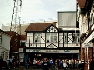
In 1898, Sir John Brickwood, who owned a brewery in Portsmouth, and five other people started the "Portsmouth Football & Athletic Company." This is now Portsmouth F.C.. They bought a potato field, about four-and-a-half acres big, from the Goldsmith farming family's Milton Farm.
In 1899, the new Portsmouth Football Club built their football ground. They called it Fratton Park, which is a bit confusing because it's actually in Milton, not Fratton! The name "Fratton Park" was chosen to make new fans think the stadium was closer to Fratton railway station than it really was (it's about a mile walk). Fratton Park opened on August 15, 1899. The eastern part of Fratton Park is even called 'The Milton End', named after the village of Milton where it's built.
Some fans today still mistakenly think Fratton Park is in Fratton because of its name. However, if you look at a map of Portsmouth, the border between Fratton and Milton is clear. It runs from Fratton Bridge along the railway line up to St. Mary's Bridge. Fratton is north of this line, and Milton is to the south. Since Fratton Park is south of the railway line, it is definitely in Milton! Also, Fratton Park has a Milton postcode (PO4 8RA), while Fratton and central Portsmouth have a "PO1" postcode. Plus, Fratton Park is part of the Milton Ward for local elections.
Milton Common: A Natural Space
On the eastern edge of Portsea Island, next to Langstone Harbour, is an area called Milton Common. This used to be a tidal inlet known as Milton Lake. Even earlier, it was called "Felder Lake," which is where the name Velder Avenue comes from.
Milton Common is land that was created by filling in the lake. This happened between 1962 and 1970. A barrier of chalk and clay was built across the mouth of the lake. Then, the area was slowly drained and filled with household rubbish and other waste. Later, it was covered with soil and grass to create Milton Common.
Milton Common was not originally planned to be a wild open space. In 1967, there were plans to fill in Milton Lake and build a big dual carriageway road there. This road would have cut through Portsea Island and connected to other motorways. Luckily for the people living in Milton, these big road plans were cancelled in 1976. Some parts of the road scheme were built in other areas, but the Milton section was never completed.
You can still see the outline of the old Milton Lake on a modern map. The A2030 Eastern Road borders it to the north, and Moorings Way road is to the south. Milton Common has many footpaths, and the eastern path along Langstone Harbour is part of the Solent Way. There are three freshwater lakes there: Frog Lake, Duck Lake, and Swan Lake. These lakes are home to many different birds and water creatures. The land is still settling, and the spaces underground in Milton Common make great homes for foxes and other wildlife.
Moorings Way, the road along the southern edge of Milton Common, got its name because many houseboats used to be moored along the edge of the old Milton Lake. After the bombings in the 1940s (the Blitz), many people who lost their homes found shelter along the north shore of Eastney Lake and into Milton Lake. It was almost like a shanty town, with makeshift houseboats, old railway carriages, and fisherman huts. Many of these homes didn't have electricity or running water, and some stayed there until the 1960s before they were cleared away.
How Milton is Governed
Milton is a special area, or Portsmouth City Council ward, within the Portsmouth South parliamentary constituency. This means that people living in Milton vote for local councillors who represent them in the Portsmouth City Council. They also vote for a Member of Parliament (MP) to represent them in the UK Parliament. The Milton ward was created in 2002.
The councillors who have represented Milton Ward in the Portsmouth City Council over the years include:
- Caroline Scott (Liberal Democrats)
- Alexander Bentley (Liberal Democrats)
- Nigel Sizer (Liberal Democrats)
- Gerald Vernon-Jackson (Liberal Democrats)
- Sarah Dinenage (Conservative Party, then Liberal Democrats)
- Will Purvis (Liberal Democrats)
- Ben Dowling (Liberal Democrats)
 | Percy Lavon Julian |
 | Katherine Johnson |
 | George Washington Carver |
 | Annie Easley |


