Pottery Addition, Ohio facts for kids
Quick facts for kids
Pottery Addition, Ohio
|
|
|---|---|

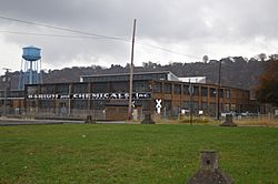
Steubenville Pottery Company buildings on Old State Route 7
|
|

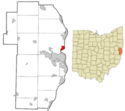
Location of Pottery Addition in Jefferson County and in the state of Ohio
|
|
| Country | United States |
| State | Ohio |
| County | Jefferson |
| Township | Island Creek |
| Area | |
| • Total | 1.09 sq mi (2.83 km2) |
| • Land | 0.85 sq mi (2.19 km2) |
| • Water | 0.25 sq mi (0.64 km2) |
| Elevation | 689 ft (210 m) |
| Population
(2020)
|
|
| • Total | 258 |
| • Density | 304.96/sq mi (117.70/km2) |
| Time zone | UTC-5 (Eastern (EST)) |
| • Summer (DST) | UTC-4 (EDT) |
| Area code(s) | 740 & 220 |
| GNIS feature ID | 2628954 |
| FIPS code | 39-64472 |
Pottery Addition is a small community in Jefferson County, Ohio, United States. It's called a "census-designated place" (CDP) because the U.S. Census Bureau defines it for counting people, even though it's not an official town. In 2020, about 258 people lived here. This community is right next to the Ohio River. You can also find Ohio State Route 7 running through it.
Contents
Location and Landscape
Pottery Addition is located in the eastern part of Jefferson County. It sits in the southeast corner of Island Creek Township. The community's eastern edge is the Ohio River. This river forms the border between Ohio and West Virginia.
Nearby Places
Right across the Ohio River from Pottery Addition is the city of Weirton, West Virginia. The southern tip of Pottery Addition also touches the border of Steubenville. Steubenville is the main city and county seat of Jefferson County.
Travel Routes
Ohio State Route 7 is a four-lane highway that goes through Pottery Addition. If you head north on Route 7, you will reach Toronto in about 5 miles (8 km). Going south on Route 7 will take you to the center of Steubenville in about 4 miles (6 km).
Area Size
According to the U.S. Census Bureau, Pottery Addition covers an area of about 1.093 square miles (2.83 km2). Most of this area, about 0.908 square miles (2.35 km2), is land. The remaining part, about 0.185 square miles (0.48 km2), is water, mainly from the Ohio River.
Population Information
| Historical population | |||
|---|---|---|---|
| Census | Pop. | %± | |
| 2020 | 258 | — | |
| U.S. Decennial Census | |||
The population of Pottery Addition was counted during the 2020 census. At that time, 258 people lived in the community. This number helps us understand how many people call Pottery Addition home.
See also
 In Spanish: Pottery Addition (Ohio) para niños
 | Selma Burke |
 | Pauline Powell Burns |
 | Frederick J. Brown |
 | Robert Blackburn |

