Prairie Farm, Wisconsin facts for kids
Quick facts for kids
Prairie Farm, Wisconsin
|
|
|---|---|

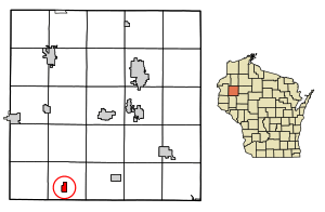
Location of Prairie Farm in Barron County, Wisconsin
|
|
| Country | |
| State | |
| County | Barron |
| Area | |
| • Total | 1.00 sq mi (2.58 km2) |
| • Land | 0.96 sq mi (2.49 km2) |
| • Water | 0.04 sq mi (0.09 km2) |
| Elevation | 1,043 ft (318 m) |
| Population
(2020)
|
|
| • Total | 494 |
| • Density | 494.0/sq mi (191.5/km2) |
| Time zone | UTC-6 (Central (CST)) |
| • Summer (DST) | UTC-5 (CDT) |
| Area code(s) | 715 & 534 |
| FIPS code | 55-65150 |
| GNIS feature ID | 1571876 |
Prairie Farm is a small village located in Barron County, which is part of the U.S. state of Wisconsin. In 2020, the village had a population of 494 people.
This village is found within the larger Town of Prairie Farm. It sits right on the eastern side of the Prairie Farm Flowage, which is a man-made lake or reservoir. This reservoir is part of the Hay River.
Contents
Where is Prairie Farm Located?
Prairie Farm is located at coordinates 45.238443 degrees north and -91.980591 degrees west.
The United States Census Bureau says that the village covers a total area of about 1.01 square miles (2.62 square kilometers). Most of this area, about 0.97 square miles (2.51 square kilometers), is land. The rest, about 0.04 square miles (0.10 square kilometers), is water.
You can find Prairie Farm along County Roads A and F, which are local roads that connect different parts of the county.
Who Lives in Prairie Farm?
| Historical population | |||
|---|---|---|---|
| Census | Pop. | %± | |
| 1880 | 80 | — | |
| 1910 | 368 | — | |
| 1920 | 299 | −18.7% | |
| 1930 | 301 | 0.7% | |
| 1940 | 335 | 11.3% | |
| 1950 | 343 | 2.4% | |
| 1960 | 350 | 2.0% | |
| 1970 | 426 | 21.7% | |
| 1980 | 387 | −9.2% | |
| 1990 | 494 | 27.6% | |
| 2000 | 508 | 2.8% | |
| 2010 | 473 | −6.9% | |
| 2020 | 494 | 4.4% | |
| U.S. Decennial Census | |||
Population in 2010
According to the census from 2010, there were 473 people living in Prairie Farm. These people lived in 201 different homes, and 114 of these were families.
The village had about 487.6 people per square mile (188.3 people per square kilometer). There were 227 housing units, meaning places where people could live.
Most of the people in the village were White (98.5%). A small number were Native American (0.2%), or from other races (0.8%). About 0.4% of the population identified as being from two or more races. People who identified as Hispanic or Latino made up 2.1% of the population.
Households and Families
Out of the 201 homes, about 26.9% had children under 18 years old living there. About 43.3% were married couples living together. Some homes (8.5%) had a female head of household with no husband present. A smaller number (5.0%) had a male head of household with no wife present.
About 43.3% of all homes were made up of individuals living alone. Of these, 16.9% had someone aged 65 or older living by themselves. On average, there were 2.16 people in each household and 2.83 people in each family.
Age of Residents
The average age of people in the village was 44.9 years old.
- About 21.1% of residents were under 18 years old.
- Around 5.2% were between 18 and 24 years old.
- About 24.1% were between 25 and 44 years old.
- Roughly 26.2% were between 45 and 64 years old.
- And 23.5% were 65 years old or older.
When it came to gender, 45.9% of the population was male, and 54.1% was female.
See also
 In Spanish: Prairie Farm (Wisconsin) para niños
 | Stephanie Wilson |
 | Charles Bolden |
 | Ronald McNair |
 | Frederick D. Gregory |

