
Preston, Maryland facts for kids
Quick facts for kids
Preston, Maryland
|
||
|---|---|---|
| Town of Preston | ||
|
||
| Nickname(s):
"The Biggest Little Town In The USA!"
|
||

Location of Preston, Maryland
|
||

Preston, Maryland
Location in Maryland

Preston, Maryland
Location in the United States
|
||
| Country | ||
| State | ||
| County | ||
| Incorporated | 1892 | |
| Area | ||
| • Total | 0.56 sq mi (1.45 km2) | |
| • Land | 0.55 sq mi (1.42 km2) | |
| • Water | 0.01 sq mi (0.03 km2) | |
| Elevation | 46 ft (14 m) | |
| Population
(2020)
|
||
| • Total | 673 | |
| • Density | 1,225.87/sq mi (473.72/km2) | |
| Time zone | UTC-5 (Eastern (EST)) | |
| • Summer (DST) | UTC-4 (EDT) | |
| ZIP code |
21655
|
|
| Area code(s) | 410 | |
| FIPS code | 24-63825 | |
| GNIS feature ID | 1681813 | |

Preston is a small town located in Caroline County, Maryland, in the United States. In 2010, about 719 people lived there. By 2020, the population was 673.
Contents
History of Preston
Preston is home to the Linchester Mill, a very old building from around 1682. This mill was important during the American Revolutionary War. It helped provide grain, which is used to make food, for George Washington's soldiers.
The Linchester Mill was added to the National Register of Historic Places in 2009. This list includes important places that are worth saving for the future. The Jacob and Hannah Leverton House was also added to this list at the same time.
A famous person named Monk Farnham once lived in Preston. He was a publisher for Boating magazine. He also set a world record for being the oldest person to sail alone across the Atlantic Ocean.
Getting Around Preston
The main way to travel to and from Preston is by road. Four state highways help people get around the town. Maryland Route 16 comes into Preston from the northeast. Maryland Route 331 enters from the northwest. These two roads join together within the town. They then leave Preston heading southeast. Maryland Route 324 and Maryland Route 817 also go through the town. These roads help connect different parts of the area.
Geography and Climate
Preston is located at coordinates 38°42′39″N 75°54′30″W / 38.71083°N 75.90833°W. This helps pinpoint its exact spot on a map.
The United States Census Bureau says that Preston covers about 0.57 square miles (1.45 square kilometers). All of this area is land.
Preston's Climate
The weather in Preston has hot and humid summers. The winters are usually mild to cool. According to the Köppen Climate Classification system, Preston has a humid subtropical climate. This type of climate is often called "Cfa" on climate maps. It means the area gets plenty of rain and has warm temperatures for most of the year.
Population Information
| Historical population | |||
|---|---|---|---|
| Census | Pop. | %± | |
| 1880 | 156 | — | |
| 1900 | 192 | — | |
| 1910 | 288 | 50.0% | |
| 1920 | 784 | 172.2% | |
| 1930 | 315 | −59.8% | |
| 1940 | 369 | 17.1% | |
| 1950 | 353 | −4.3% | |
| 1960 | 469 | 32.9% | |
| 1970 | 509 | 8.5% | |
| 1980 | 498 | −2.2% | |
| 1990 | 437 | −12.2% | |
| 2000 | 566 | 29.5% | |
| 2010 | 719 | 27.0% | |
| 2020 | 673 | −6.4% | |
| U.S. Decennial Census | |||
Preston in 2010
In 2010, the town of Preston had 719 people living there. There were 264 households, which are groups of people living in one home. About 190 of these households were families.
Many homes, about 40%, had children under 18 living with them. Most households, around 56%, were married couples living together. The average household had about 2.72 people. The average family had about 3.14 people.
The average age of people in Preston was 35.2 years old. About 27% of the residents were under 18 years old. Around 12% of the people were 65 years old or older. The town had a nearly equal number of males and females.
Images for kids
-
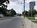
Maryland Route 16 and Maryland Route 331 meet in central Preston.
_at_Chambers_Street_in_Preston,_Caroline_County,_Maryland.jpg)
See also
 In Spanish: Preston (Maryland) para niños
