Preston, Nevada facts for kids
Quick facts for kids
Preston, Nevada
|
|
|---|---|
|
Census-designated place
|
|

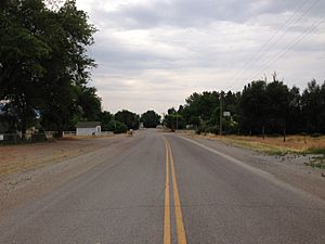
Nevada State Route 895 in Preston, July 2014
|
|
| Country | United States |
| State | Nevada |
| County | White Pine |
| Area | |
| • Total | 1.29 sq mi (3.35 km2) |
| • Land | 1.29 sq mi (3.35 km2) |
| • Water | 0.00 sq mi (0.00 km2) |
| Elevation | 5,636 ft (1,718 m) |
| Population
(2020)
|
|
| • Total | 76 |
| • Density | 58.82/sq mi (22.71/km2) |
| Time zone | UTC-8 (Pacific (PST)) |
| • Summer (DST) | UTC-7 (PDT) |
| ZIP code |
89317
|
| Area code(s) | 775 |
| FIPS code | 32-58000 |
| GNIS feature ID | 0845604 |
Preston is a small community in White Pine County, Nevada, United States. It is known as a census-designated place, which means it's an area identified by the United States Census Bureau for statistical purposes.
What is Preston, Nevada?
Preston was started by Mormon settlers in 1876. They named the town after William B. Preston. He was an important leader in the Church of Jesus Christ of Latter-day Saints. He served as the fourth Presiding Bishop of the church from 1884 to 1907.
The main ways people make a living in Preston are through farming and ranching. The town is located at a high elevation of about 5,636 feet (1,718 meters) above sea level. In 2010, about 78 people lived in Preston.
How Many People Live in Preston?
The United States Census Bureau counts how many people live in different places every ten years. This helps us understand how communities are growing or changing.
| Historical population | |||
|---|---|---|---|
| Census | Pop. | %± | |
| 2010 | 78 | — | |
| 2020 | 76 | −2.6% | |
| U.S. Decennial Census | |||
In 2010, the population of Preston was 78 people. By 2020, the population had slightly decreased to 76 people.
See also
 In Spanish: Preston (Nevada) para niños
 | John T. Biggers |
 | Thomas Blackshear |
 | Mark Bradford |
 | Beverly Buchanan |


